U.S. Route 431 in Kentucky
| ||||
|---|---|---|---|---|
| Route information | ||||
| Maintained by KYTC | ||||
| Length: | 86.936 mi[1] (139.910 km) | |||
| Existed: | 1952 – present | |||
| Major junctions | ||||
| South end: |
| |||
|
| ||||
| North end: |
| |||
| Location | ||||
| Counties: | Logan, Muhlenberg, McLean County, Daviess | |||
| Highway system | ||||
| ||||

U.S. Route 431 (US 431) in Kentucky runs 86.465 miles (139.152 km) from the Tennessee state line south of Adairville to US 60 at Owensboro. It crosses the state in mainly west-central portions of the state, passing through or near towns such as Russellville, Lewisburg, Central City and Livermore. The route goes through Logan, Muhlenberg, McLean County, and Daviess Counties.
Route description
US 431 enters the state going out of Robertson County, Tennessee, and into Logan County south of Adairville. It goes northward to Russellville, where it makes a left turn, and then a right turn to follow the Russellville Bypass to the north side of town. It becomes known as the Terry Wilcut Highway from Russellville to Lewisburg.[2]
It enters Muhlenberg County to provide access to Lake Malone (via KY 973, and then goes on a northwesterly course to Central City, where it intersects the Wendell H. Ford Western Kentucky Parkway at a cloverleaf interchange, and the U.S. Route 62. Along the way to Central City from near Drakesboro, Kentucky Route 70 runs concurrently with the U.S. Route.
It then goes due north from Central City into eastern McLean County, crosses the Bridge at Livermore, where it crosses both the Green and Rough Rivers. It enters Daviess County and traverses the communities of Livia and Utica before terminating at the Wendell H. Ford Expressway (US 60) at Owensboro.[3]
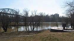
For a unique reason, the U.S. 431 crossing of the Green River and Rough Rivers in McLean County, Kentucky, is a famous river crossing. It is at that crossing in the city of Livermore that U.S. 431 crosses two rivers and also crosses into Ohio County before completing the river crossing back in McLean County. This is the only known crossing of this type in the United States: a road starts in one county, crosses two separate rivers, crosses a sliver of land within another county, and then terminates the bridge crossing in the original county it started in. This special feature is marked by a state historical marker on both approach ends of the bridge.
History
| |
|---|---|
| Location: | South Carrollton-Owensboro, Kentucky |
| Length: | 31.357 mi[4] (50.464 km) |
| Existed: | 1929–1953 |
In 1953, US 431 was extended into Tennessee and Kentucky from the Huntsville, Alabama area. From 1929, the US 431 corridor in Kentucky was originally signed as Kentucky Routes 75 and 81. KY 75 ran from Owensboro to KY 81 at South Carrollton, while KY 81 ran its current course, plus the rest of US 431's original route from South Carrollton into Central City and Russellville to the Tennessee state line.[5]
US 431's original alignment in the city of Russellville became Kentucky Route 3519 in the mid 2000s when the main US 431 alignment was rerouted onto the Russellville Bypass on the west side of town. As of mid-2010, Frederica Street in Owensboro no longer carries the US 431 designation into downtown Owensboro as KY 2831 is assigned onto that street.
In 2011, the US 431 alignment in Central City was rerouted onto the former KY 189 bypass on the west side of that city. This was done due to the low clearance of a bridge carrying the Paducah and Louisville Railroad tracks. US 431's original alignment in downtown is now designated as Kentucky Route 1031.
Major intersections
| County | Location | mi[1] | km | Destinations | Notes |
|---|---|---|---|---|---|
| Robertson | | 0.000 | 0.000 | Continuation into Tennessee | |
| Logan | Adairville | 1.481 | 2.383 | ||
| | 4.145 | 6.671 | |||
| | 7.375 | 11.869 | Eastern terminus of KY-2371 | ||
| | 8.252 | 13.280 | Western terminus of KY-664 | ||
| Russellville | 12.708 | 20.452 | Northern terminus of KY 96 | ||
| 13.896 | 22.363 | Southern terminus of KY-2146; Western terminus of KY-3240; original alignment of US 79 | |||
| 14.903 | 23.984 | Southern terminus of KY-3233 | |||
| 14.996 | 24.134 | Northern terminus of US-79 | |||
| 15.987 | 25.729 | Western terminus of US 68 Business; western end of US 68 overlap | |||
| 16.56 | 26.65 | ||||
| 17.568 | 28.273 | Eastern end of US 68 overlap | |||
| Epleys Station | 21.593 | 34.751 | Northern terminus of KY 3519 | ||
| Lewisburg | 24.746 | 39.825 | Southern end of KY-106 concurrency | ||
| 24.959 | 40.168 | Northern/eastern terminus of KY 107 | |||
| 25.272 | 40.671 | Northern end of KY 106 concurrency | |||
| | 32.143 | 51.729 | Northern terminus of KY-1293 | ||
| Muhlenberg | Dunmor | 34.218 | 55.069 | Eastern terminus of KY 973 | |
| Penrod | 37.091 | 59.692 | Western terminus of KY 949 | ||
| Belton | 41.182 | 66.276 | |||
| Beechmont | 42.238 | 67.975 | Eastern terminus of KY 246 | ||
| Browder | 44.052 | 70.895 | Southern end of KY-70 concurrency | ||
| Drakesboro | 45.685 | 73.523 | |||
| 46.184 | 74.326 | No access to KY-2107 North from SB US-431/KY-70; southern terminus of KY-2107 | |||
| 46.254 | 74.439 | Connector road to KY-2107, primarily for traffic heading south on 431/70 | |||
| Cleaton | 50.74 | 81.66 | Northern terminus of KY 2107 | ||
| | 51.452 | 82.804 | Southern terminus of KY 604 | ||
| Central City | 51.699– 51.747 | 83.201– 83.279 | WK Parkway Exit 58 | ||
| 52.48 | 84.46 | US 431 and KY 70 turns left onto US 62 | |||
| 53.071 | 85.409 | ||||
| 53.854 | 86.670 | Southern terminus of KY 277 | |||
| 53.939 | 86.806 | Northern end of US 62 concurrency | |||
| 55.314 | 89.019 | Northern end of KY 70 concurrency | |||
| South Carrollton | 57.725 | 92.899 | Northern terminus of KY-1031; original alignment of US 431 | ||
| 58.635 | 94.364 | Southern terminus of KY 81 | |||
| | 62.606 | 100.755 | Northern terminus of KY-175 | ||
| McLean | Island | 66.74 | 107.41 | ||
| | 68.328 | 109.963 | Northern terminus of KY-1412 | ||
| 68.928 | 110.929 | Eastern terminus of KY 138 | |||
| Livermore | 69.067– 69.379 | 111.153– 111.655 | Livermore Bridge over the Green and Rough Rivers | ||
| 69.923 | 112.530 | Southern end of KY 136 concurrency | |||
| 70.047 | 112.730 | Northern end of KY 136 concurrency | |||
| Nuckols | 72.239 | 116.257 | |||
| | 73.826 | 118.811 | Eastern terminus of KY 250 | ||
| Daviess | Utica | 78.146 | 125.764 | ||
| Sutherland | 82.762 | 133.193 | Western terminus of KY 298 | ||
| | 83.574 | 134.499 | Eastern terminus of KY 554 | ||
| Owensboro | 86.499 | 139.207 | Eastern terminus of KY 2121 | ||
| 86.936 | 139.910 | Exit 14 of Expressway | |||
| 86.936 | 139.910 | Northern terminus of US 431; Continuation as KY 2831; southern terminus of KY 2831 | |||
1.000 mi = 1.609 km; 1.000 km = 0.621 mi
| |||||
See also
-
 Kentucky portal
 -
 U.S. Roads portal
 - U.S. Route 431
- Kentucky Route 81
References
- 1 2 Commonwealth of Kentucky. "Official DMI Route Log". Retrieved 5 July 2016.
- ↑ DeLorme (2010). Kentucky Atlas & Gazetteer (Map) (4th ed.). Yarmouth, ME: DeLorme. pp. 63 & 80.
- ↑ DeLorme (2010). Kentucky Atlas & Gazetteer (Map) (4th ed.). Yarmouth, ME: DeLorme. pp. 45 & 62.
- ↑ Determined by adding the mileage of US 431 from the KY 81 junction to the northern terminus, plus the entire length of KY 2831.
- ↑ Kentucky Department of State Highways (September 15, 1939). Road Map of Kentucky (PDF) (Map). c. 1:760,320. Frankfort: Kentucky Department of State Highways.
External links
| Previous state: Tennessee |
Kentucky | Next state: Terminus |