Bannered routes of U.S. Route 19
| |
|---|---|
| Highway system | |

Several bannered routes of U.S. Route 19 exist. In order from south to north they are as follows.
Existing
St. Petersburg–Holiday alternate route
| |
|---|---|
| Location: | St. Petersburg-Holiday, Florida |
| Length: | 40.08 mi[1] (64.50 km) |
| Existed: | 1951– |

Alternate U.S. Route 19 is the 40.08-mile (64.50 km) former section of U.S. Route 19 from St. Petersburg, Florida to Holiday.
Beginning at the intersection of 4th Street N (US 92 and SR 687 and 5th Avenue N in St. Petersburg, Florida, it runs west of US 19 near the Gulf coast passing through the cities of Seminole, Clearwater, Dunedin and Tarpon Springs before ending at US 19 in Holiday, Pasco County, Florida. It is also the unsigned State Road 595 throughout the entire route. It also runs along much of the Pinellas Trail.
Albany business loop
| |
|---|---|
| Location: | Albany, Georgia |
U.S. Route 19 Business (US 19 Business) in Albany, Georgia is co-signed with US BUS 82 throughout its entire length. It begins at Exit 2B on the Liberty Expressway and joins westbound US BUS 82. From there US BUS 19/82 turn north at Georgia State Route 234, and joins a concurrency with that route until both business routes end at Exit 6 which is the west end of the US 19/82 overlap, and the east end of the US 82/GA 234 overlap.
Leesburg bypass route
| |
|---|---|
| Location: | Leesburg, Georgia |
U.S. Route 19 Bypass is a short western bypass of the town of Leesburg in Lee County, which was completed in 2009.[2] It is concurrent with State Route 3 Bypass and briefly with State Route 32.
Griffin business loop
| |
|---|---|
| Location: | Griffin, Georgia |
U.S. Route 19 Business (US 19 Business) in Griffin, Georgia is co-signed with Bus US 41. It begins at the intersection of US 19/41 and Georgia State Route 155, and follows GA 155 north around Griffin-Spalding County Airport. Then it turns west at Georgia State Route 16 until it curves onto Georgia State Route 92 until finally ending at a wye interchange with US 19/41.
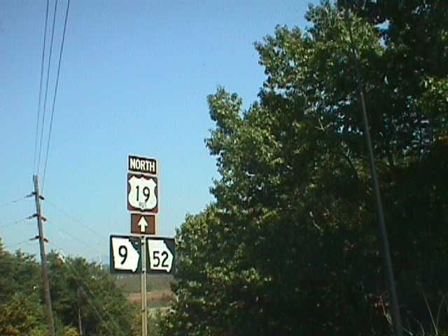
Dahlonega business loop
| |
|---|---|
| Location: | Dahlonega, Georgia |
U.S. Route 19 Business in Dahlonega is signed with both Georgia State Route 9 and Georgia State Route 52[3]
Murphy business loop
| |
|---|---|
| Location: | Murphy, North Carolina |
| Length: | 3 mi (5 km) |
| Existed: | 1980–present |
U.S. Route 19 Business is a 3 miles (4.8 km) business route established in 1980 that replaced the original US 19 routing through the city of Murphy, along Hiwassee Street, Valley River Avenue, Hill Street, Andrews Road and Pleasant Valley Road.[4]
Andrews business loop
| |
|---|---|
| Location: | Andrews, North Carolina |
| Length: | 3 mi (5 km) |
| Existed: | 1979–present |
U.S. Route 19 Business is a 3 miles (4.8 km) business route established in 1979 replaced the original US 19 routing through the city of Andrews, along Main Street.[4]
Bryson City–Lake Junaluska truck route
| |
|---|---|
| Location: | Bryson City–Lake Junaluska, NC |
| Length: | 39.3 mi[5] (63.2 km) |
U.S. Route 19 Truck (US 19 Truck) is a truck route of US 19 located in Western North Carolina. Its routing follows the former routing of US 19A (1976-1983) and US 19 Bypass (1983-1987) along the Great Smoky Mountains Expressway, between Bryson City and Lake Junaluska. Signage appears only at the end points, with no reassurance signs along route.
Bryson City connector
| |
|---|---|
| Location: | Bryson City, North Carolina |
| Length: | 0.72 mi[6] (1.16 km) |
| Existed: | 2011–present |

U.S. Route 19 Connector (US 19 Conn) is a .72-mile (1.16 km) connector route established on October 2011, that connect US 19 (Main Street) with US 74 (Great Smoky Mountains Expressway). Also known as Veterans Boulevard, it was upgraded to primary status because of real need of maintenance and Swain County's secondary route budget was unable to support it. The route is an undivided four-lane the entire length and serves as the main entrance to Bryson City.[7]
The entire route is in Bryson City, Swain County.
| mi[6] | km | Destinations | Notes | ||
|---|---|---|---|---|---|
| 0.00 | 0.00 | ||||
| 0.72 | 1.16 | ||||
| 1.000 mi = 1.609 km; 1.000 km = 0.621 mi | |||||
Asheville business loop
| |
|---|---|
| Location: | Asheville, North Carolina |
| Length: | 2.3 mi[8] (3.7 km) |
| Existed: | 1960–present |
U.S. Route 19 Business (US 19 Bus), established in 1960, is a 2.3 miles (3.7 km) business route currently starts on Haywood Road then go north on I-26/I-240 (exit 2) back to the main US 19 (exit 3). Historically, US 19 Business continued along Haywood Road, connecting to Clingman Avenue and then to Patton Avenue/US 19. In 1961, it extended over Patton Avenue through downtown Asheville when US 19 moved onto the East-West Freeway. In 1962, it was rerouted to its current alignment from Haywood Road to Hanover Street (now I-26/I-240). It is co-signed with US 23 Bus.[4]
Weaverville business loop
| |
|---|---|
| Location: | Weaverville, North Carolina |
| Length: | 5.5 mi[9] (8.9 km) |
| Existed: | 1967–present |
U.S. Route 19 Business, established on September 1967, this 5.5 miles (8.9 km) business route follows the original US 19 mainline through the city of Weaverville. The business loop is clearly marked along the route, though the freeway bypass (I-26/US 19/US 23) does not mention it. It starts from exit 23 interchange (with a brief overlap with US 25), then goes north along Weaverville Road and Main Street; it reconnects with the freeway at the exit 18 interchange via Clarks Chapel Road/Monticello Road.[4][10]
The entire route is in Buncombe County.
| Location | mi[9] | km | Destinations | Notes | |
|---|---|---|---|---|---|
| Woodfin | 0.0 | 0.0 | Brief overlap with US 25 | ||
| Weaverville | 4.5 | 7.2 | Weaver Boulevard | ||
| 5.5 | 8.9 | ||||
| 1.000 mi = 1.609 km; 1.000 km = 0.621 mi | |||||
Bristol truck route
| |
|---|---|
| Location: | Bristol, Virginia |
| Length: | 2.2 mi[11] (3.5 km) |
U.S. Route 19 Truck (US 19 Truck), which shares a complete concurrency with US 11 Truck, provides a bypass route for truckers avoiding the residential area of Euclid Avenue.
Lebanon business loop
| |
|---|---|
| Location: | Lebanon, Virginia |
| Length: | 4.0 mi[12] (6.4 km) |
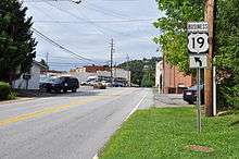
Tazewell business loop
| |
|---|---|
| Location: | Tazewell, Virginia |
| Length: | 8.0 mi[13] (12.9 km) |
U.S. Route 19 Business (US 19 Business) is an eight-mile business route of US 460 in Tazewell, Virginia. It is co-signed with Bus US 460.
Pittsburgh truck route
| |
|---|---|
| Location: | Pittsburgh, Pennsylvania |
| Length: | 19.4 mi[14] (31.2 km) |
| Existed: | 1946–present |
U.S. Route 19 Truck (US 19 Truck) is a truck route of U.S. Route 19 (US 19) located in Western Pennsylvania in the Pittsburgh Metro Area that has a length of 19 miles (31 km). It is a loop off US 19; the southern terminus located in Mt. Lebanon and the northern terminus in McCandless Township, connecting to US 19 at both ends. The route is notable for a large, unorthodox interchange with the Penn–Lincoln Parkway (I-376/US 22/US 30) just west of the Fort Pitt Tunnel, where the route joins the Parkway and forms several wrong-way concurrencies, including one with its own opposing directions.[15] North of Pittsburgh, U.S. Route 19 Truck is called McKnight Road and south of Pittsburgh it carries West Liberty Avenue and Washington Road.
Harlansburg truck route
| |
|---|---|
| Location: | Harlansburg, Pennsylvania |
| Existed: | 2013–present |
U.S. Route 19 Truck is a truck route around a weight-restricted bridge over a branch of the Slippery Rock Creek on which trucks over 32 tons are prohibited. The route follows Pennsylvania Route 108, Pennsylvania Route 388, Pennsylvania Route 168, and Pennsylvania Route 956. The route was signed in 2013.
Former
Brooksville alternate route
| |
|---|---|
| Location: | Bayonet Point–Brooksville, FL |
| Length: | 32 mi[16] (51 km) |
| Existed: | 1937–1938 |
U.S. Route 19 Alternate was a former segment of US 19 that ran from Bayonte Point to Brooksville, Florida, which only existed for one year. It ran along what is today State Road 52 from Bayonet Point to Gowers Corner, and then turned north along US 41 into Brooksville.
Thomasville business loop
| |
|---|---|
| Location: | Thomasville–Ochlocknee, GA |
| Existed: | 1961–1985 |
Waynesville alternate route
| |
|---|---|
| Location: | Waynesville, North Carolina |
| Existed: | 1939–1948[16] |
U.S. Route 19 Alternate (US 19A) was routed through downtown Waynesville along with US 23A (today as US 23 Business).[16]
Ela–Lake Junaluska alternate route
| |
|---|---|
| Location: | Ela–Lake Junaluska, NC |
| Length: | 28.8 mi[17] (46.3 km) |
| Existed: | 1947–1948[16] |
U.S. Route 19 Alternate (US 19A) was established in 1947, replacing part of NC 28, between Ela and Cherokee, and all of NC 293 between Cherokee and Lake Junaluska, via Soco Gap. In 1948, US 19 and US 19A swapped routes.[16]
Bryson City–Lake Junaluska alternate route
| |
|---|---|
| Location: | Bryson City–Lake Junaluska, NC |
| Length: | 39.3 mi[5] (63.2 km) |
| Existed: | 1948–1983[18] |
U.S. Route 19 Alternate (US 19A) was established in 1948 when US 19 swapped routes with the previous US 19A between Ela and Lake Junaluska, via Soco Gap. US 19A followed the old alignment of US 19 from Ela, through Dillsboro, Sylva and Waynesville, to Lake Junaluska. Between 1954-1957, US 19A/US 23 was placed onto current routing bypassing Balsam. Between 1958-1962, US 19A/US 23 was placed on one-way streets through Sylva; northbound via Main Street and southbound via Mill Street. In 1967, US 19A/US 23 was rerouted on new freeway bypass west of Waynesville; its old alignment becoming US 23 Bus.[19] In 1974, US 19A was placed on new freeway bypass north of Dillsboro and Sylva; its old alignment becoming US 23 Bus.[20] In 1975, the relocation around Sylva was submitted to AASHTO for approval, but was denied by the subcommittee; despite the denial, NCDOT left signage as is.[21] In 1976, US 19A was placed on new freeway bypass east of Bryson City, from Alarka Road to US 441; its old alignment from Ela to Whittier was downgraded to secondary road.[22] In 1982, NCDOT submitted a request to AASHTO to switch US 19 and US 19A between Bryson City and Lake Junaluska; but was later withdrawn before the vote.[23] In 1983, US 19A was redesignated US 19 Bypass; despite the change, signage along the route maintained US 19A during and after US 19 Bypass was also eliminated in 1987.[18]
Bryson City–Lake Junaluska bypass
| |
|---|---|
| Location: | Bryson City–Lake Junaluska, NC |
| Length: | 39.3 mi[5] (63.2 km) |
| Existed: | 1983–1987[18][24] |
U.S. Route 19 Bypass (US 19 By-Pass) was established in 1983 as a redesignation of US 19A between Bryson City and Lake Junaluska; this also coincide the establishment of the Great Smoky Mountains Expressway. In 1987, US 19 Bypass was eliminated in favor for US 74, which was extended west of Asheville the prior year. Despite being officially US 19 Bypass, signage along the route remained US 19A throughout, with some signs still marking the route til the mid-1990s.[24][25]
Asheville alternate route
| |
|---|---|
| Location: | Asheville, North Carolina |
| Length: | 2.3 mi[26] (3.7 km) |
| Existed: | 1949–1960[16] |
U.S. Route 19 Alternate (US 19A) was routed along Haywood Road through Asheville. This route was re-branded as US 19 Business in 1960.[16]
See also
-
 Florida portal
 -
.svg.png) Georgia (U.S. state) portal
Georgia (U.S. state) portal -
 North Carolina portal
 -
 Virginia portal
 -
 Pennsylvania portal
 -
 Pittsburgh portal
 -
 U.S. Roads portal
References
- ↑ http://www.dot.state.fl.us/planning/statistics/pdfs/fedaidreport.pdf FDOT Federal Aid Report Archived January 12, 2007, at the Wayback Machine.
- ↑ Georgia Department of Transportation. "Archived copy" (PDF). Archived from the original (PDF) on 2011-02-20. Retrieved 2014-05-05., Lee County 2009 Revision Map. Accessed on 15 November 2012.
- ↑ Steve Williams photo; October 1998 (Gribblenation: Georgia Road Photos Gallery) Archived October 27, 2007, at the Wayback Machine.
- 1 2 3 4 "NCRoads.com: US 19 Business". Archived from the original on 25 November 2010. Retrieved 2010-10-31.
- 1 2 3 Google (October 22, 2014). "U.S. Route 19 Alt/Bypass Bryson City-Lake Junaluska, NC" (Map). Google Maps. Google. Retrieved October 22, 2014.
- 1 2 Google (January 29, 2013). "US 19 Connector - Bryson City" (Map). Google Maps. Google. Retrieved January 29, 2013.
- ↑ "US 19 Conn Route Change (2011-10-26)" (PDF). North Carolina Department of Transportation. October 26, 2011. Retrieved January 27, 2013.
- ↑ Google (December 1, 2013). "US 19 Business - Asheville" (Map). Google Maps. Google. Retrieved December 1, 2013.
- 1 2 Google (2011-07-23). "US 19 Bus - Weaverville" (Map). Google Maps. Google. Retrieved 2011-07-23.
- ↑ "US 19 Bus Route Change (1967-09-29)" (PDF). North Carolina Department of Transportation. September 29, 1967. Retrieved January 27, 2013.
- ↑ Google (February 24, 2013). "US 11/19 Truck - Bristol, Virginia" (Map). Google Maps. Google. Retrieved February 24, 2013.
- ↑ Google (February 24, 2013). "US 19 Business - Lebanon, Virginia" (Map). Google Maps. Google. Retrieved February 24, 2013.
- ↑ Google (February 24, 2013). "US 19 Business - Tazewell, Virginia" (Map). Google Maps. Google. Retrieved February 24, 2013.
- ↑ DeLorme Street Atlas USA 2007
- ↑ Multiplexed Roads - Image of 5 route concurrency
- 1 2 3 4 5 6 7 19a1 "Florida in Kodachrome: Alternate US 19 (West Florida)" Check
|url=value (help). Retrieved 2011-11-20. - ↑ Google (October 22, 2014). "U.S. Route 19A Ela-Lake Junaluska, NC" (Map). Google Maps. Google. Retrieved October 22, 2014.
- 1 2 3 Special Committee on U.S. Route Numbering (June 20, 1983). "Route Numbering Committee Agenda" (PDF) (Report). Fairfield Bay, AR: American Association of State Highway and Transportation Officials. p. 2. Retrieved October 22, 2014 – via Wikimedia Commons.
- ↑ "Route Change (1967-08-04)" (PDF). North Carolina Department of Transportation. August 4, 1967. Retrieved October 22, 2014.
- ↑ "Route Change (1974-09-01)" (PDF). North Carolina Department of Transportation. September 1, 1974. Retrieved October 22, 2014.
- ↑ Special Committee on U.S. Route Numbering (June 17, 1975). "Route Numbering Committee Agenda Showing Action Taken by the Executive Committee" (PDF) (Report). White Sulphur Springs, WV: American Association of State Highway and Transportation Officials. p. 3. Retrieved October 22, 2014 – via Wikimedia Commons.
- ↑ "Route Change (1976-10-01)" (PDF). North Carolina Department of Transportation. October 1, 1976. Retrieved October 22, 2014.
- ↑ Special Committee on U.S. Route Numbering (June 28, 1982). "Route Numbering Committee Agenda" (PDF) (Report). Portsmouth, NH: American Association of State Highway and Transportation Officials. p. 4. Retrieved October 22, 2014 – via Wikimedia Commons.
- 1 2 Special Committee on U.S. Route Numbering (May 25, 1987). "Route Numbering Committee Agenda" (PDF) (Report). Biloxi, MS: American Association of State Highway and Transportation Officials. p. 3. Retrieved October 22, 2014 – via Wikimedia Commons.
- ↑ "Route Change (1987-06-15)" (PDF). North Carolina Department of Transportation. June 15, 1987. Retrieved October 22, 2014.
- ↑ Google (2011-02-02). "US 19A-5" (Map). Google Maps. Google. Retrieved 2011-02-02.
External links
 Media related to U.S. Route 19 at Wikimedia Commons