U.S. Route 197
| |||||||
|---|---|---|---|---|---|---|---|
|
US 197 is highlighted in red. | |||||||
| Route information | |||||||
| Auxiliary route of US 97 | |||||||
| Maintained by ODOT and WSDOT | |||||||
| Length: | 69.93 mi[lower-alpha 1] (112.54 km) | ||||||
| Existed: | 1952[3] – present | ||||||
| Major junctions | |||||||
| South end: |
| ||||||
|
| |||||||
| North end: |
| ||||||
| Location | |||||||
| States: | Oregon, Washington | ||||||
| Counties: |
OR: Wasco WA: Klickitat | ||||||
| Highway system | |||||||
| |||||||

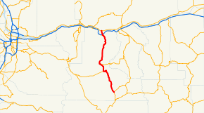
U.S. Route 197 (US 197) is a north–south United States Highway, of which all but 2.76 miles of its 69.93 miles (4.44 of 112.54 km) are within the state of Oregon. The highway starts in rural Wasco County in Central Oregon at an intersection with US 97. US 197 travels north as a continuation of The Dalles-California Highway No. 4 through the cities of Maupin, Tygh Valley, and Dufur to The Dalles. Within The Dalles, the highway becomes concurrent with US 30 and intersects Interstate 84 (I-84) before it crosses over the Columbia River on The Dalles Bridge into Washington. The highway continues through the neighboring city of Dallesport in Klickitat County and terminates at a junction with State Route 14 (SR 14).
US 197 was established in 1952 using the existing The Dalles-California Highway, itself created as a part of the initial named Oregon highways in 1917. US 197 traveled from its current northern terminus at Dallesport to US 97 in Maryhill along Primary State Highway 8 (PSH 8) and US 830, successors to the original State Road 8 designated along the corridor in 1907. The Dallesport–Maryhill section was transferred to SR 14 in 1979, but was not recognized by the American Association of State Highway and Transportation Officials (AASHTO) until 2006.
Route description
US 197 runs 69.93 miles (112.54 km) in Oregon and Washington and is maintained by the Oregon Department of Transportation (ODOT) and Washington State Department of Transportation (WSDOT).[1][2]
Oregon

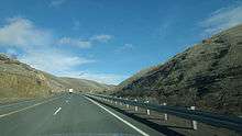
US 197 begins at an intersection with US 97 at Shaniko Junction in unincorporated Wasco County, located between the cities of Madras and Shaniko in Central Oregon.[4] The highway, a continuation of The Dalles-California Highway No. 4,[5] travels northwest over the 3,363-foot-high (1,025 m) Criterion Summit and down along Stag Canyon through the community of Criterion towards Maupin.[6][7] US 197 crosses the Deschutes River and a BNSF rail line on a warren truss bridge,[8][9] becoming Deschutes Avenue as it passes South Wasco County High School and through the city of Maupin.[10][11] The highway continues west into the Juniper Flat and intersects Oregon Route 216 (OR 216), designated as Wapinitia Highway No. 44,[5] and forms a concurrency.[12] US 197 and OR 216 travel north and northwest to Tygh Valley,[13] where OR 216 leaves the concurrency and heads east on Sherars Bridge Highway No. 290 towards Grass Valley.[5][14][15] The lone highway continues north up Butler Canyon onto Tygh Ridge,[16][17] passing through the 2,710-foot-high (830 m) Tygh Grade Summit.[18] US 197 travels east of Dufur and down into the Columbia River Gorge, entering the city of The Dalles.[19][20][21] The highway begins a 0.24-mile-long (0.39 km) concurrency with US 30, traveling north over an east–west BNSF rail line to a diamond interchange with I-84.[9] US 197 leaves the interchange and the state of Oregon on The Dalles Bridge, crossing over the Columbia River into Washington.[22][23][24] An ODOT survey measuring traffic volume for any average day of the year, expressed in terms of annual average daily traffic (AADT), was conducted in 2011 on US 197 and calculated that the busiest section of the highway in Oregon was on The Dalles Bridge, serving 5,800 vehicles, while the least busiest section of the highway was north of its terminus at US 97, serving 390 vehicles.[25]
Washington

US 197 enters Washington on The Dalles Bridge, a steel cantilever truss bridge that crosses the Columbia River downstream of The Dalles Dam,[26][27] and travels into Dallesport in Klickitat County.[28] The 2.76-mile-long (4.44 km) highway continues north past Columbia Gorge Regional Airport to its northern terminus, an intersection with SR 14.[2][24][29] US 197 is defined by the Washington State Legislature as SR 197, part of the Revised Code of Washington as §47.17.382.[30] Every year, WSDOT conducts a series of surveys on its highways in the state to measure traffic volume, expressed in terms of AADT. In 2012, WSDOT calculated that the Washington section of US 197 served between 3,700 and 6,100 vehicles, mostly on The Dalles Bridge.[31]
History
US 197 within Washington was added to the state highway system in 1907 as State Road 8, later designated as PSH 8 in 1937, traveling east along the Columbia River from Vancouver to Maryhill.[32][33][34] US 197 within Oregon is designated as a segment of The Dalles-California Highway No. 4, created as part of the initial named state highway system, adopted by the Oregon State Highway Commission on November 27, 1917.[3] The highway traveled south from The Dalles through Central Oregon to the California state line south of Klamath Falls.[35][36] Under the United States Numbered Highway system, approved by the American Association of State Highway Officials (AASHO) on November 11, 1926,[37] State Road 8 in Washington was co-signed with US 830 from Vancouver to Maryhill and The Dalles-California Highway in Oregon was co-signed with US 97 from Shaniko Junction to the California state line.[38] The Oregon State Highway Department created a numbered state highway system to compliment the U.S. route system on May 18, 1937, and The Dalles-California Highway from Shaniko Junction to The Dalles was numbered as OR 50.[3] OR 50 was renumbered to OR 23 on May 26, 1950 and became the Oregon section of US 197 when it was established in 1952.[3]
US 197 traveled north onto the newly constructed The Dalles Bridge over the Columbia River to US 830 and PSH 8 northeast of Dallesport and traveled east with the two highways to end at US 197 in Maryhill.[33][39] US 830 and its concurrency with US 197 were removed from the U.S. route system in 1968,[40][41][42] leaving US 197 concurrent with the successor to PSH 8, SR 14, after the 1964 state highway renumbering.[43] The concurrency with SR 14 was removed from the Washington state highway system in 1979,[30][44] but remained as a part of US 197 as defined by the American Association of State Highway and Transportation Officials (AASHTO) until September 22, 2006.[45]
Major intersections
| State | County | Location | mi[lower-alpha 2] | km | Destinations | Notes |
|---|---|---|---|---|---|---|
| Oregon | Wasco | Shaniko Junction | 0.00 | 0.00 | Southern terminus | |
| | 24.74 | 39.82 | South end of OR 216 overlap | |||
| Tygh Valley | 33.28 | 53.56 | North end of OR 216 overlap | |||
| The Dalles | 66.24 | 106.60 | South end of US 30 overlap | |||
| 66.48– 66.56 | 106.99– 107.12 | Interchange, north end of US 30 overlap | ||||
| Columbia River | 67.17 0.00 | 108.10 0.00 | The Dalles Bridge Oregon–Washington state line | |||
| Washington | Klickitat | | 2.76 | 4.44 | Northern terminus | |
1.000 mi = 1.609 km; 1.000 km = 0.621 mi
| ||||||
Notes
References
- 1 2 3 "Straightline Charts: The Dalles-California Highway No. 4" (PDF). Oregon Department of Transportation. May 2012. pp. 1–3. Retrieved March 4, 2013.
- 1 2 3 4 Staff (2012). "State Highway Log: Planning Report 2012, SR 2 to SR 971" (PDF). Washington State Department of Transportation. p. 1212. Retrieved March 4, 2013.
- 1 2 3 4 Singh, Ron (January 2007). "History of State Highways in Oregon" (PDF). Oregon Department of Transportation. pp. 89–98. Retrieved March 22, 2013.
- ↑ "Feature Detail Report for: Shaniko Junction". Geographic Names Information System. United States Geological Survey. November 28, 1980. Retrieved March 4, 2013.
- 1 2 3 "Cross Reference Table of Highway Route Number to State Highway Number" (PDF). Oregon Department of Transportation. 2011. Retrieved March 4, 2013.
- ↑ "Feature Detail Report for: Criterion Summit". Geographic Names Information System. United States Geological Survey. November 28, 1980. Retrieved March 4, 2013.
- ↑ "Feature Detail Report for: Criterion (historical)". Geographic Names Information System. United States Geological Survey. September 10, 1979. Retrieved March 4, 2013.
- ↑ "Feature Detail Report for: Deschutes River". Geographic Names Information System. United States Geological Survey. November 28, 1980. Retrieved March 4, 2013.
- 1 2 State of Oregon: Oregon Railroads (PDF) (Map). Oregon Department of Transportation. July 7, 2010. Retrieved March 4, 2013.
- ↑ "Feature Detail Report for: South Wasco County High School". Geographic Names Information System. United States Geological Survey. May 26, 1986. Retrieved March 4, 2013.
- ↑ "Feature Detail Report for: Maupin". Geographic Names Information System. United States Geological Survey. November 28, 1980. Retrieved March 4, 2013.
- ↑ "Feature Detail Report for: Juniper Flat". Geographic Names Information System. United States Geological Survey. November 28, 1980. Retrieved March 4, 2013.
- ↑ "Feature Detail Report for: Tygh Valley". Geographic Names Information System. United States Geological Survey. November 28, 1980. Retrieved March 4, 2013.
- ↑ Oregon Transportation Map Showing Federal Functional Classification of Roads: Wasco County (PDF) (Map). Oregon Department of Transportation. 2012. p. 2. Retrieved March 4, 2013.
- ↑ Oregon Transportation Map Showing Federal Functional Classification of Roads: Wasco County (PDF) (Map). Oregon Department of Transportation. 2012. p. 3. Retrieved March 4, 2013.
- ↑ "Feature Detail Report for: Butler Canyon". Geographic Names Information System. United States Geological Survey. November 28, 1980. Retrieved March 4, 2013.
- ↑ "Feature Detail Report for: Tygh Ridge". Geographic Names Information System. United States Geological Survey. November 28, 1980. Retrieved March 4, 2013.
- ↑ "Feature Detail Report for: Tygh Ridge Summit". Geographic Names Information System. United States Geological Survey. November 28, 1980. Retrieved March 4, 2013.
- ↑ "Feature Detail Report for: Dufur". Geographic Names Information System. United States Geological Survey. November 28, 1980. Retrieved March 4, 2013.
- ↑ "Feature Detail Report for: Columbia Gorge". Geographic Names Information System. United States Geological Survey. October 15, 2009. Retrieved March 4, 2013.
- ↑ "Feature Detail Report for: The Dalles". Geographic Names Information System. United States Geological Survey. November 28, 1980. Retrieved March 4, 2013.
- ↑ "Feature Detail Report for: Columbia River". Geographic Names Information System. United States Geological Survey. November 28, 1980. Retrieved March 4, 2013.
- ↑ Oregon Transportation Map Showing Federal Functional Classification of Roads: Wasco County (PDF) (Map). Oregon Department of Transportation. 2012. p. 1. Retrieved March 4, 2013.
- 1 2 Google (July 24, 2008). "U.S. Route 197" (Map). Google Maps. Google. Retrieved July 24, 2008.
- ↑ Staff (2011). "Traffic Volumes on State Highways" (PDF). Oregon Department of Transportation. p. 6. Retrieved April 20, 2013.
- ↑ "Feature Detail Report for: The Dalles Bridge". Geographic Names Information System. United States Geological Survey. September 10, 1979. Retrieved March 4, 2013.
- ↑ "Feature Detail Report for: The Dalles Dam". Geographic Names Information System. United States Geological Survey. September 10, 1979. Retrieved March 4, 2013.
- ↑ "Feature Detail Report for: Dallesport". Geographic Names Information System. United States Geological Survey. September 10, 1979. Retrieved March 4, 2013.
- ↑ "Feature Detail Report for: Columbia Gorge Regional/The Dalles Municipal Airport". Geographic Names Information System. United States Geological Survey. March 2, 2011. Retrieved March 4, 2013.
- 1 2 "47.17.382: State route No. 197". Revised Code of Washington. Washington State Legislature. 1979 [1973]. Retrieved July 24, 2008.
- ↑ Staff (2012). "2012 Annual Traffic Report" (PDF). Washington State Department of Transportation. p. 156. Retrieved March 23, 2013.
- ↑ Washington State Legislature (March 13, 1907). "Chapter 151: Providing for the Establishment, Construction and Maintenance of State Roads and Making Appropriations for Certain State Roads". Session Laws of the State of Washington. Session Laws of the State of Washington (1907 ed.). Olympia, Washington: Washington State Legislature. pp. 310–311. Retrieved March 17, 2013.
State Road No. 8, or the Columbia River road: This road shall begin at the town of Washougal in Clarke county, Washington, and run thence over the line as surveyed for such state road through Clarke and Skamania counties, and thence over the most practicable route to the town of Goldendale, in Klickitat county.
- 1 2 Washington State Legislature (March 17, 1937). "Chapter 190: Establishment of Primary State Highways". Session Laws of the State of Washington. Session Laws of the State of Washington (1937 ed.). Olympia, Washington: Washington State Legislature. pp. 937–938. Retrieved March 17, 2013.
SEC. 8. A primary state highway to be known as Primary State Highway No. 8, or the Evergreen Highway, is hereby established according to description as follows: Beginning at Vancouver on Primary State Highway No. 1, thence in an easterly direction by the most feasible route by way of Stevenson to Goldendale, thence in a northeasterly direction by the most feasible route by way of Satus Pass to a junction with Primary State Highway No. 3, southeast of Yakima.
- ↑ Long, Priscilla (June 12, 2006). "The Dalles Bridge spanning the Columbia River is completed on December 18, 1953.". HistoryLink. Retrieved March 17, 2013.
- ↑ Constitution and statutes of the state of Oregon relating to roads, highways, bridges and ferries. Oregon Secretary of State. 1917. Retrieved March 10, 2013.
- ↑ "To Cinder State Highway". The Spokesman-Review. June 19, 1917. p. 13. Retrieved March 17, 2013.
- ↑ Weingroff, Richard F. (January 9, 2009). "From Names to Numbers: The Origins of the U.S. Numbered Highway System". Highway History. Federal Highway Administration. Retrieved March 17, 2013.
- ↑ Bureau of Public Roads & American Association of State Highway Officials (November 11, 1926). United States System of Highways Adopted for Uniform Marking by the American Association of State Highway Officials (Map). 1:7,000,000. Washington, DC: U.S. Geological Survey. OCLC 32889555. Retrieved November 7, 2013 – via University of North Texas Libraries.
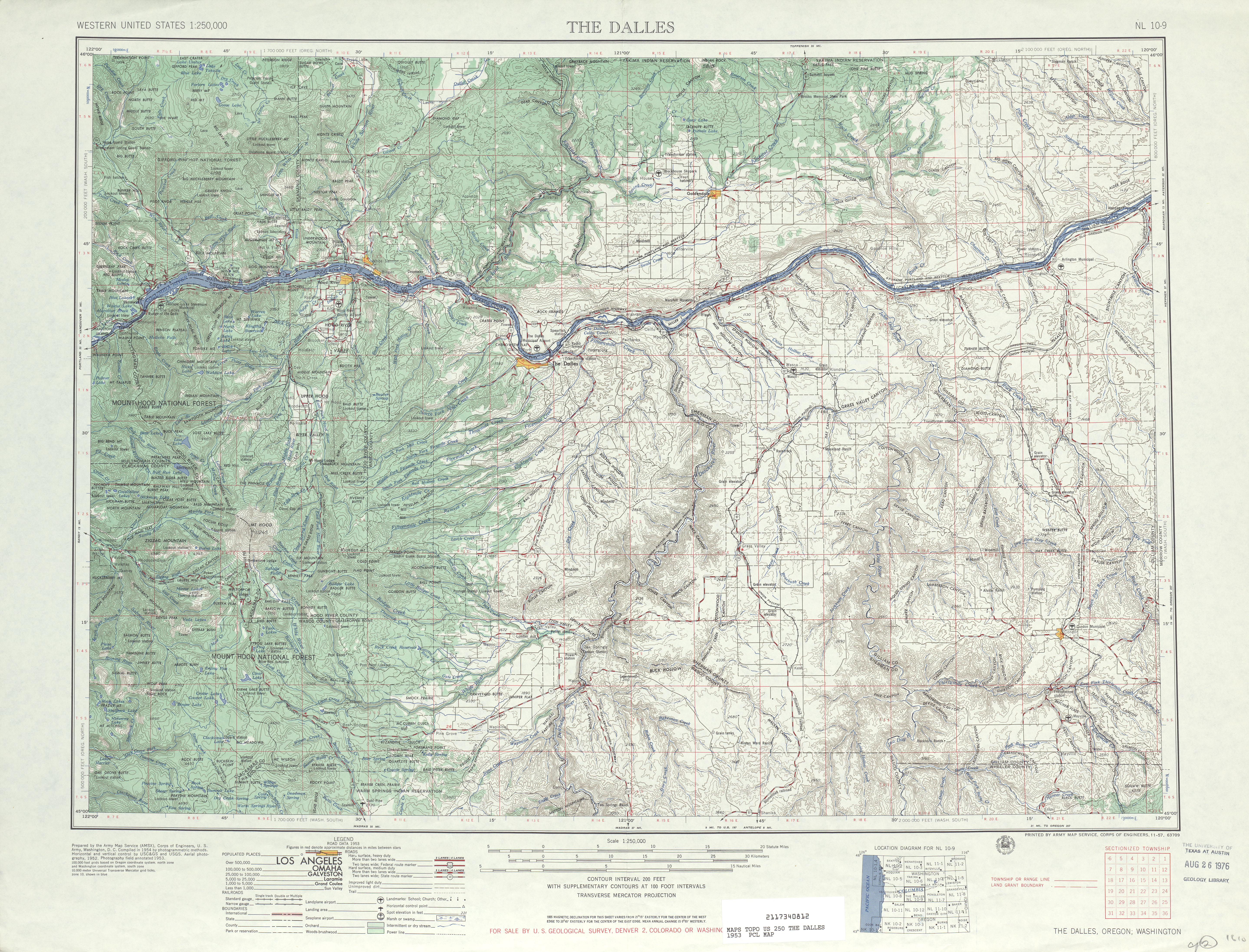
- ↑ The Dalles, 1953 (JPG) (Map). 1:250,000. United States Geological Survey. 1953. Retrieved March 17, 2013.
- ↑ Northwest, 1967 (Map). Rand McNally. 1967. Retrieved March 17, 2013.
- ↑ The Dalles, 1971 (JPG) (Map). 1:250,000. United States Geological Survey. 1971. Retrieved March 17, 2013.
- ↑ "State Approves Route Extension". Lewiston Morning Tribune. April 21, 1966. p. 12. Retrieved March 22, 2013.
- ↑ Prahl, C. G. (December 1, 1965). "Identification of State Highways" (PDF). Washington State Highway Commission, Department of Highways. Retrieved March 17, 2013.
- ↑ Staff (1980). "Annual Traffic Report, 1980" (PDF). Washington State Department of Transportation. p. 152. Retrieved March 16, 2013.
- ↑ Washington State Department of Transportation (September 22, 2006). "An Application from the State Highway or Transportation Department of Washington for the Elimination of U.S. Route 197 (part)" (PDF). American Association of State Highway and Transportation Officials. Retrieved March 11, 2013.
External links
- US 197 at US Highway Ends
- The Dalles-California Highway #4 at Oregon Highways
- US 197 at Highways of Washington State