U.S. Route 190
| |
|---|---|
 | |
| Route information | |
| Auxiliary route of US 90 | |
| Length: | 875 mi[1] (1,408 km) |
| Existed: | 1926[1] – present |
| Major junctions | |
| West end: |
|
|
| |
| East end: |
|
| Location | |
| States: | Texas, Louisiana |
| Highway system | |

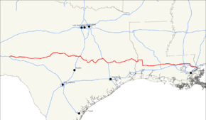
U.S. Route 190 is an east–west United States highway in Louisiana and Texas. It evolved from the shortest of intrastate routes in 1926 to a length comparable to a main Interstate Highway route, leading from the swamps and pine forests of Louisiana to the West Texas desert.
Route description
| mi[2] | km | |
|---|---|---|
| TX | 593 | 854 |
| LA | 282 | 454 |
| Total | 875 | 1408 |
Texas
The western terminus is at a point where US 190 intersects with Interstate 10, a few miles east of Bakersfield and 20 mi (32 km) west of the town of Iraan, in the middle of Pecos County.
It runs east through Texas Hill Country speckled with sage brush, intersecting with State Highway 305, crossing into Schleicher County, and intersecting with U.S. Route 277 in Eldorado. Just outside Eldorado was where the raid of the Yearning for Zion Ranch gained national attention. US 190 continues east into Menard County, intersecting State Highway 864, and passing a few miles north of Fort McKavett State Historic Site, entering Menard and intersecting with U.S. Route 83 north a short distance.
Continuing on a northeastward route US 190 enters McCulloch County and into Brady, Texas. Being the closest city to the geographical center of Texas, the city proclaims being the "True Heart of Texas", "where five major highways meet, making it a major gateway to all regions of the state".[3] US 190 enters Brady from the south merging and running concurrent with north U.S. Route 377 and U.S. Route 87 through town, intersecting FM 2028, 2309, then splitting with US 87 and US 377, before exiting the city heading east. US 190 goes through Rochelle, enters San Saba County, through Richland Springs where it intersects FM 45, the communities Algerita, and Harkeyville, and into San Saba, the birthplace of actor Tommy Lee Jones, and an intersection with State Highway 16. Continuing east US 190 enters Lampasas County, entering Lometa, merging and running concurrent with U.S. Route 183 south into the city of Lampasas. Splitting from US 183 and continuing east US 190 runs through the town of Kempner entering the extreme southern corner of Coryell County and the city of Copperas Cove. Copperas Cove is located on the southeastern edge of Fort Hood and US 190 traverses through part of the fort, into Bell County and then Killeen. Being directly adjacent to the main cantonment of Fort Hood, both Killeen and Copperas Cove depend on the fort and those stationed there. A restaurant in Killeen was the site of one of the worst mass shootings in U.S. history where 23 people (including the shooter) were killed.[4][5]
US 190 next intersects and merges with I-35 north through Belton and enters Temple, merging and running concurrent with State Highway 36 south. Continuing east and south US 190 passes through Rogers and enters Milam County then Cameron and merges with U.S. Route 77 south for a distance. A few miles south of Cameron US 190 merges and runs concurrent with U.S. Route 79 north. In Hearne US 190 splits with US 79 and merges running concurrent with State Highway 6 south, entering Brazos County, through Benchley, and into Bryan, that is considered the heart of the Brazos Valley (Southeast Central Texas), and is part of the Bryan-College Station metropolitan area.
US 190 splits with State Highway 6, turning northeast and merging with State Highway 21 north, entering through Kurten, entering Madison County also passing through North Zulch, Cottonwood and into Madisonville, before merging with I-45 south and into Walker County, then entering Huntsville, where US 190 splits heading into Eastern Texas.
Continuing east, US 190 enters San Jacinto County, passing north of Oakhurst and Point Blank, crossing Lake Livingston, entering Polk County and into Onalaska. US 190 from the west makes a semi-loop up over Lake Livingston and down to Livingston, intersecting with US 59 and Business US 59 and through Alabama-Coushatta Indian Reservation, entering Tyler County, merging with FM 256 and into Woodville. East of Woodville FM 256 splits north and US 190 crosses BA Steinhagen Lake, into Jasper County, intersecting with State Highway 63 east, and in the center of Jasper intersecting with U.S. Route 96. Continuing east US 190 travels through Holly Springs enters Newton County and proceeds into Newton. In Newton US 190 turns south through Bon Wier, and then crosses the Louisiana line.
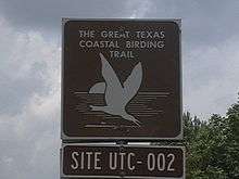
In Newton County, Texas, US 190 has been designated one of the routes on the Great Texas Coastal Birding Trail. The site number attached to the signs denote the location of the sign. The sign in the picture is located on the westbound side of the highway, inside the Texas line, just west of the "Welcome to Texas" sign near the Sabine River (Texas-Louisiana).
Louisiana
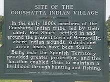
US 190 crosses the Sabine River and enters the western portion of Louisiana in swampy bayou terrain three miles (5 km) west of Merryville, Louisiana. Merryville is the location of the old Coushatta Indian village.
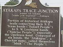
From Merryville the highway heads north by northeast to the community of Junction, Louisiana, also referred to as The Junction.[6] Junction is where LA 111 and US 190 intersect and is the site of a roadside marker and the joining of two Indian trails.
From Junction, US 190 heads east to DeRidder, where it forms a multiplex with US 171 south and passes several NRHP sites such as the Beauregard Parish Jail, Beauregard Parish Courthouse, and the DeRidder Commercial Historic District among others. US 190 runs concurrently with US 171 to Ragley, where US 190 parts with US 171 heading east. From Ragley, the two-lane highway heads nearly due east almost parallel to Interstate 10 until Opelousas. US 190 crosses the northern reach of the Atchafalaya Basin near the Morganza Spillway en route to Baton Rouge. From Baton Rouge, US 190 passes, in places divided, through Denham Springs, Albany, Hammond, Robert, Goodbee, Covington,[7] Mandeville, before reaching the eastern terminus at Slidell (US 11).
The stretch between Interstate 12 south of Covington and the intersection with LA 22 at Mandeville is multilane divided with controlled access. The highway's eastern terminus is in the bayous near Slidell, at an intersection with U.S. Route 90. This junction was once known as the "White Kitchen" after a restaurant that was once located there.[8][9]
History
In the original 1926 plan, U.S. 190 served the purpose of modern-day Interstate 12, as the road around the north side of Lake Pontchartrain. The western terminus was in Baton Rouge, Louisiana, meeting U.S. 71 at the Baton Rouge-Port Allen Mississippi River ferry. U.S. 190 followed State Route 7 (in the pre-1955 Louisiana Highway system) east to Covington, then State Route 34 from Covington to Slidell. The original eastern terminus in Slidell was at U.S. 90 (now U.S.11) at the modern intersection of Front Street and Gause Boulevard.
In 1935, the route was extended west across the Mississippi River, ending in the West Texas town of Brady at an intersection with U.S. 87.
U.S. 190 was assigned an additional 150 miles (240 km) across the sparsely-populated area south of San Angelo, Texas in 1979.
Louisiana
The original 1926 route followed the Jefferson Highway through downtown Baton Rouge, then LA 426 (Old Hammond Highway) to the Amite River. East of Baton Rouge, significant differences from the current alignment are as follows: LA 1032 through Denham Springs; LA 1027 into Walker; LA 43 and 1040 (Old Baton Rouge Highway) between Albany and Hammond; South Range Road and LA 1067 (Old Covington Highway) between Hammond and the Tangipahoa River; and U.S. 190 Business through Covington.
West of Baton Rouge, the current alignment generally follows the same route since its extension into Texas in 1935. The only major re-routing was between Deridder and Elton, where the original route followed LA 26. The portion between Oberlin and Elton was re-routed in 1937 to follow U.S. 165 to Kinder before assuming the current alignment between Deridder and Kinder the following year. Other differences from the current route are as follows: LA 110 through Merryville; LA 3099 into DeRidder; LA 3253, 1244, 31, and 742 between Opelousas and Port Barre; Old U.S. 190 between Bayou Courtableau and Krotz Springs and between East Krotz Springs, Louisiana Krotz Springs and Lottie; LA 77 between Livonia and Rosedale; and LA 76 between Rosedale and Port Allen.
In 1937, U.S. 190 took over the original route of U.S. 90 from Slidell to the Rigolets Bridge (along current U.S. 11 and LA 433) when that highway assumed its current routing into Mississippi. U.S. 190 was given its current eastern terminus at U.S. 90 in the 1940s, following what is now U.S. 190 Business (Fremaux Avenue) through Slidell until the 1970s when it was shifted onto Gause Boulevard.
In 1951, U.S. 190 was re-routed along U.S. 51 Business (mainline U.S. 51 at the time) and LA 22 between Hammond and Mandeville. The new route passed through Ponchatoula and Madisonville and bypassed Covington. The former route through Covington was restored in 1956.
The current U.S. 190 near Krotz Springs, Louisiana, is an elevated highway. The road was built as a bypass around the road called Old 190 which continues across the Morganza Spillway to the western edge of Lottie. U.S. 190 crosses the Atchafalaya River on two cantilever bridges known as the Krotz Springs Bridge. It crosses the Mississippi River on the 1940-era Huey Long Bridge north of Baton Rouge.
The route is now used as an alternate route for Interstate 10, across the Atchafalaya Expressway. Traffic can be diverted along LA 975 to Krotz Springs, and LA 76 to U.S. 190/LA 1.
Junction list
| State | County/Parish | Location | mi | km | Destinations | Notes |
|---|---|---|---|---|---|---|
| Texas | Pecos | | I-10 exit 307 | |||
| | ||||||
| | West end of SH 349 overlap | |||||
| Iraan | East end of SH 349 overlap | |||||
| Crockett | | West end of SH 137 overlap | ||||
| | East end of SH 137 overlap | |||||
| | ||||||
| Schleicher | | |||||
| Eldorado | West end of US 277 overlap | |||||
| East end of US 277 overlap | ||||||
| | ||||||
| | ||||||
| Menard | | |||||
| Menard | West end of US 83 overlap | |||||
| | North end of US 83 overlap | |||||
| McCulloch | | |||||
| Brady | West end of US 87/377 overlap | |||||
| East end of US 87 overlap | ||||||
| East end of US 377 overlap | ||||||
| Rochelle | ||||||
| | ||||||
| | ||||||
| San Saba | | |||||
| Richland Springs | ||||||
| | ||||||
| | ||||||
| San Saba | ||||||
| | ||||||
| Lampasas | Lometa | |||||
| West end of US 183 overlap | ||||||
| | ||||||
| | West end of US 281 overlap | |||||
| Lampasas | West end of FM 580 overlap | |||||
| East end of FM 580 overlap | ||||||
| East end of US 281 overlap | ||||||
| East end of US 183 overlap | ||||||
| Kempner | ||||||
| Coryell | Copperas Cove | eastbound exit and westbound entrance | ||||
| Interchange; west end of freeway | ||||||
| Old Copperas Cove Road | Interchange | |||||
| Interchange; westbound exit and eastbound entrance | ||||||
| Fort Hood | Clarke Road | |||||
| Bell Tower Drive | ||||||
| Bell | ||||||
| North Clear Creek Road | Eastbound Exit | |||||
| T.J. Mills Boulevard | ||||||
| Killeen | ||||||
| Trimmier Road | ||||||
| W.S. Young Drive | ||||||
| Rosewood Drive | Eastbound Exit. Westbound signed at Stan Schlueter Loop | |||||
| Harker Heights | ||||||
| No westbound entrance | ||||||
| Nolanville | ||||||
| Paddy Hamilton Road | ||||||
| | Frontage Road | Eastbound exit only | ||||
| | Frontage Road | Westbound exit only | ||||
| | ||||||
| | G Wilson Road | |||||
| Belton | ||||||
| Eastbound exit and entrance | ||||||
| Eastbound exit and westbound entrance; west end of I-35 overlap; I-35 exit 293A-B | ||||||
| Central Avenue | I-35 exit 294A | |||||
| I-35 exit 294B | ||||||
| Temple | Midway Drive | I-35 exit 297 | ||||
| East end of I-35 overlap; west end of SH 36/Loop 363 overlap; I-35 exit 298 | ||||||
| 57th Street, Oakdale Drive | ||||||
| 5th Street | ||||||
| East end of freeway; no eastbound exit | ||||||
| Interchange; east end of Loop 363 overlap | ||||||
| | ||||||
| | Interchange | |||||
| | Interchange; eastbound exit is via the FM 93 exit | |||||
| | ||||||
| Rogers | ||||||
| Milam | Buckholts | West end of FM 1915 overlap | ||||
| East end of FM 1915 overlap | ||||||
| | ||||||
| | ||||||
| Cameron | ||||||
| West end of US 77 overlap | ||||||
| | ||||||
| | East end of US 77 overlap | |||||
| Milano | West end of US 79 overlap | |||||
| East end of SH 36 overlap | ||||||
| Gause | ||||||
| Robertson | | |||||
| | ||||||
| Hearne | Interchange; east end of US 79 overlap; west end of SH 6 overlap | |||||
| | ||||||
| Benchley | West end of freeway | |||||
| Brazos | Bryan | |||||
| Eastbound exit and westbound entrance | ||||||
| Frontage Road | Eastbound exit only | |||||
| Woodville Road | ||||||
| West end of SH 21 overlap; east end of SH 6 overlap; east end of freeway | ||||||
| Wixon Valley | ||||||
| | ||||||
| Kurten | ||||||
| | ||||||
| | ||||||
| Madison | | Interchange | ||||
| North Zulch | ||||||
| | ||||||
| | West end of FM 1452 overlap | |||||
| | East end of FM 1452 overlap | |||||
| Madisonville | ||||||
| East end of SH 21 overlap; west end of I-45 overlap; I-45 exit 142 | ||||||
| | I-45 exit 136 | |||||
| Walker | | I-45 exit 132 | ||||
| | I-45 exit 123 | |||||
| Huntsville | I-45 exit 118 | |||||
| East end of I-45 overlap; west end of SH 30 overlap; I-45 exit 116 | ||||||
| West end of SH 75 overlap | ||||||
| East end of SH 75 overlap | ||||||
| East end of SH 30 overlap | ||||||
| | ||||||
| | ||||||
| San Jacinto | | |||||
| Point Blank | ||||||
| | ||||||
| Polk | Onalaska | |||||
| | ||||||
| | ||||||
| Livingston | ||||||
| West end of FM 350 overlap | ||||||
| East end of FM 350 overlap | ||||||
| US 59 exit 434B; future Interstate 69 | ||||||
| | ||||||
| Alabama- Coushatta Reservation | ||||||
| Tyler | | |||||
| Woodlawn | ||||||
| | ||||||
| | ||||||
| | ||||||
| Jasper | | |||||
| | ||||||
| Jasper | ||||||
| West end of SH 63 overlap | ||||||
| East end of SH 63 overlap | ||||||
| | ||||||
| Newton | Newton | |||||
| West end of Loop 500 overlap | ||||||
| East end of Loop 500 overlap | ||||||
| | ||||||
| | ||||||
| Bon Wier | ||||||
| Sabine River | Unnamed bridge (Texas–Louisiana state line) | |||||
| Louisiana | Beauregard | Merryville | ||||
| | ||||||
| | ||||||
| DeRidder | ||||||
| West end of US 171 overlap | ||||||
| | ||||||
| | ||||||
| | ||||||
| Longville | ||||||
| | Interchange; east end of US 171 overlap | |||||
| Allen | Reeves | |||||
| Kinder | ||||||
| | ||||||
| Jefferson Davis | Elton | |||||
| | ||||||
| Evangeline–Acadia parish line | Basile | |||||
| | ||||||
| | ||||||
| Acadia | Eunice | |||||
| Saint Landry | | |||||
| | West end of LA 95 overlap | |||||
| | East end of LA 95 overlap | |||||
| | ||||||
| | ||||||
| Lawtell | ||||||
| Opelousas | ||||||
| | Interchange; I-49 exit 19 A-B | |||||
| | Prudhomme Lane | Interchange; westbound exit and eastbound entrance | ||||
| | ||||||
| | ||||||
| Port Barre | West end of LA 103 overlap | |||||
| East end of LA 103 overlap | ||||||
| | ||||||
| | Interchange | |||||
| | ||||||
| Krotz Springs | ||||||
| Interchange | ||||||
| Saint Landry–Pointe Coupee parish line | | Bridge over the Atchafalaya River | ||||
| Pointe Coupee | | Interchange | ||||
| Lottie | ||||||
| | ||||||
| Livonia | ||||||
| | ||||||
| | West end of LA 1 overlap | |||||
| West Baton Rouge | | |||||
| | ||||||
| | Interchange | |||||
| | Interchange; east end of LA 1 overlap | |||||
| | ||||||
| West Baton Rouge–East Baton Rouge parish line | | Bridge over the Mississippi River | ||||
| East Baton Rouge | | Mississippi River turnaround | Interchange | |||
| Baton Rouge | Interchange; west end of US 61 overlap | |||||
| Interchange; I-110 exit 5B | ||||||
| Interchange | ||||||
| Interchange | ||||||
| Interchange; east end of US 61 overlap | ||||||
| | ||||||
| Livingston | Denham Springs | |||||
| West end of LA 16 overlap | ||||||
| East end of LA 16 overlap | ||||||
| | West end of LA 1026 overlap | |||||
| | East end of LA 1026 overlap | |||||
| Walker | ||||||
| Satsuma | ||||||
| Livingston | West end of LA 63 overlap | |||||
| East end of LA 63 overlap | ||||||
| Holden | ||||||
| Albany | ||||||
| Tangipahoa | Hammond | Interchange; I-55 exit 31 | ||||
| | ||||||
| | ||||||
| Robert | ||||||
| Saint Tammany | | |||||
| Covington | ||||||
| | Interchange; westbound exit and eastbound entrance | |||||
| | Interchange; I-12 exit 63 A-B | |||||
| | Fairway Drive, Judge Tanner Boulevard | Interchange | ||||
| | Interchange | |||||
| Mandeville | ||||||
| | ||||||
| Lacombe | West end of LA 434 overlap | |||||
| East end of LA 434 overlap | ||||||
| | ||||||
| Slidell | ||||||
| I-10 exit 266 | ||||||
| | ||||||
| | ||||||
| | ||||||
1.000 mi = 1.609 km; 1.000 km = 0.621 mi
| ||||||
Major intersections
- Texas
-
 I‑10 west-southwest of Iraan
 -
 US 277 in Eldorado. The highways travel concurrently through Eldorado.
 -
 US 83 in Menard. The highways travel concurrently to north of Menard.
 -

 US 87 / US 377 in Brady. The highways travel concurrently through Brady.
 -
 US 183 south of Lometa. The highways travel concurrently to Lampasas.
 -
 US 281 in Lampasas. The highways travel concurrently through Lampasas.
 -
 I‑35 in Belton. The highways travel concurrently to Temple.
 -
 US 77 in Cameron. The highways travel concurrently to southeast of Cameron.
 -
 US 79 in Milano. The highways travel concurrently to Hearne.
 -
 I‑45 in Madisonville. The highways travel concurrently to Huntsville.
 -
.svg.png)
 Future I‑69 / US 59 in Livingston
 -

 US 69 / US 287 in Woodville
 -
 US 96 in Jasper
 - Louisiana
-
 US 171 in DeRidder. The highways travel concurrently to Ragley.
 -
 US 165 in Kinder
 -

 I‑49 / US 167 east of Opelousas
 -
 US 71 west-northwest of Krotz Springs
 -
 US 61 in Baton Rouge. The highways travel concurrently through Baton Rouge.
 -
 I‑110 in Baton Rouge
 -
 I‑55 in Hammond
 -
 US 51 in Hammond
 -
 I‑12 north of Mandeville
 -
 US 11 in Slidell
 - I‑10 in Slidell
-
 US 90 east-southeast of Slidell
Other designations for U.S. 190
- Acadiana Trail / Evangeline Highway — U.S. 190 in Louisiana
- Earl Rudder Freeway and Central Texas Expressway — U.S. 190 in Texas (part of future Interstate 14)
See also
![]() U.S. Roads portal
U.S. Roads portal
![]() Louisiana portal
Louisiana portal
![]() Texas portal
Texas portal
References
- 1 2 Droz, Robert V. U.S. Highways : From US 1 to (US 830). URL accessed 6 March 2006.
- ↑ "U.S. Route Number Database" (Dec 2009 ed.). American Association of State Highway and Transportation Officials. Retrieved 2011-04-08.
- ↑ -geographical center city and gateway
- ↑ -Killeen shooting --Oct. 16, 1991
- ↑ -Killeen shooting
- ↑ -Mapquest
- ↑ West of Covington the original US 190 splits from US 190 and is signed as US 190 Business. US 190 Business is joined by LA 21, and US 190 Business and LA 21 are co-signed in a concurrency through Covington until US 190 Business folds back into US 190, whence LA 21 turns northeast toward Bogalusa.
- ↑ White Kitchen Birding
- ↑ "Louisiana, page 3 - U.S. Hwy. 90 - The Southern Route 66".