Airline Highway
| |
|---|---|
|
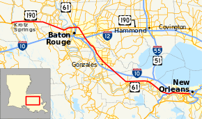
Route of the Airline Highway highlighted in red | |
| Route information | |
| Maintained by Louisiana DOTD | |
| Length: | 115.6 mi[1] (186.0 km) |
| Existed: |
1925 (planned); 1927 (first section opened); 1953 (last section opened) – present |
| Component highways: |
|
| Major junctions | |
| Southeast end: |
|
|
| |
| Northwest end: |
|
| Location | |
| Parishes: | Orleans, Jefferson, St. Charles, St. John the Baptist, St. James, Ascension, East Baton Rouge, West Baton Rouge, Pointe Coupee |
| Highway system | |
| |


Airline Highway is a divided highway in the U.S. state of Louisiana, built in stages between 1925 and 1953 to bypass the older Jefferson Highway. It runs 115.6 miles (186.0 km),[1] carrying U.S. Highway 61 from New Orleans northwest to Baton Rouge and U.S. Highway 190 from Baton Rouge west over the Mississippi River on the Huey P. Long Bridge. US 190 continues west towards Opelousas on an extension built at roughly the same time.
The highway was named "Airline" because it runs relatively straight on a new alignment, rather than alongside the winding Mississippi River. (Compare with the similar term air-line railroad.) The name later became even more fitting, as both Louis Armstrong New Orleans International Airport and Baton Rouge Metropolitan Airport were built along the highway. Airline Highway also runs close to the site of the old Baton Rouge airfield (near the intersection of Airline and Florida Boulevard, now a park and government office complex), which brings it within blocks of the similarly named Airport Avenue and Airway Drive.
History
The highway's origin is famously identified with Governor Huey P. Long, who advocated for a modern highway system in Louisiana. Though the project was underway when Long took office, most of its initial construction was completed during his administration. The Airline Highway was considered a pet project of Long's as it reduced the length of his journey between the capitol building in Baton Rouge and the bars and establishments in New Orleans.[2] Originally, Airline Highway was a two-lane road that ran from Prairieville to Shrewsbury. The first section, running between Williams Boulevard in Kenner and Shrewsbury Road, opened in June 1927.[3] It was begun by the Jefferson Parish Police Jury as a local road and incorporated into the plan for Airline Highway during construction.[4] The remainder of the highway was built between 1928 and 1933 by the Louisiana Highway Commission with federal aid, as the road would carry US 61 upon completion.
The section north of the spillway was officially opened on July 4, 1933,[5] and the section on the south side followed three weeks later.[6] (Various sections had been temporarily opened to traffic beginning in October 1931.) Completion of the bridge over the Bonnet Carré Spillway was delayed until 1935, necessitating a detour over the Jefferson Highway (River Road) via temporary gravel roads along the spillway guide levees.[7] The spillway bridge was opened to traffic on September 28, 1935[8] and dedicated on December 13.[9]
At this time, traffic was routed from Prairieville into Baton Rouge over the Jefferson Highway (today's LA 73). On the New Orleans end, travelers had the option to continue on Airline Highway and follow Metairie Road (the original route of Jefferson Highway) into town or transfer to the Jefferson Highway (today's LA 48) at Kenner and follow the direct connection onto South Claiborne Avenue completed in 1928.
The first improvements to the Airline Highway began in 1935 and consisted of widening and re-surfacing the Kenner-Shrewsbury link built a decade earlier. The new four-lane section from Williams Boulevard to Haring Road opened in October 1937.[10] The new four- and six-lane section from Haring Road to Labarre Road opened in December 1938.[11] The latter project included a slight re-alignment and extension on the Shrewsbury end. (Present-day Robertson Street is a remnant of the old alignment.) The eight-lane extension into Tulane Avenue (reached by a now-demolished six-lane bridge over the former New Basin Canal) was officially opened on August 26, 1940.[12]
Also in 1940, the Old Mississippi River Bridge opened in Baton Rouge. With this occurrence, a 7.9 mile bypass was built around the city that went to the Nesser Overpass, opening to traffic in July 1941—this bypass was part of Airline Highway, but it was not connected to the rest of the highway until 1953. A further extension continued west to the Atchafalaya Bridge at Krotz Springs. The remainder of the highway was multilaned in sections during the 1940s and the 1950s. For a short time in that decade, it was the longest toll-free four-lane highway in the nation, as the multilaned portion ran 124 miles from the Atchafalaya River to New Orleans.[13] The spillway bridge carried four very narrow lanes of traffic (often resulting in accidents) until 1984 when a parallel bridge was constructed.[14]
The majority of the New Orleans-Baton Rouge section was built parallel to the Louisiana Railway and Navigation Company, which was itself built later than the slightly longer Yazoo and Mississippi Valley Railroad. The former Louisiana Railway, now part of the Kansas City Southern Railway, crosses the Huey Long Bridge with the highway and splits to the northwest towards Shreveport; the extension to Opelousas parallels the New Orleans, Texas and Mexico Railway (later part of the Missouri Pacific Railroad).
Originally US Highways 65 and 51 were cosigned to Airline (65 the entire length, and 51 from LaPlace to New Orleans). In 1951, Louisiana truncated the route lengths, and the highway, with the exception of a portion in north Baton Rouge, is signed as US 61.
In an effort to clean up the highway's notorious history due to the seedy hotels and motels that once lined it, the portion in Jefferson Parish has been renamed Airline Drive.
Baton Rouge Bypass

The portion of the Airline Highway north and east of downtown Baton Rouge carries U.S. Highway 61 and U.S. Highway 190 around downtown, and includes several interchanges. The bypass was designated U.S. Highway 61/190 Bypass from 1957 to 1963,[15] after which US 61 and US 190 were moved onto it, and their old routes through downtown became US 61 Business/US 190 Business. The bypass and business routes originally intersected in a traffic circle, which was replaced in 1963 by a cloverleaf interchange.

In the original 1955 plan for urban Interstate Highways, numbered by 1959, the Baton Rouge bypass was designated Interstate 410; it would have connected to Interstate 10 on both ends (as I-10 would have used the US 190 corridor immediately west of Baton Rouge, still crossing the Atchafalaya Swamp in its present location). The route was cancelled by the end of the 1960s (and the number was later reused for another Interstate 410).
Major intersections
| Parish | Location | mi[1] | km | Destinations | Notes |
|---|---|---|---|---|---|
| Orleans | New Orleans | 0.0 | 0.0 | Southeastern terminus; south end of US 61 concurrency | |
| 0.1– 0.4 | 0.16– 0.64 | Exit 232 on I-10 | |||
| Jefferson | Metairie | 2.7– 3.2 | 4.3– 5.1 | Interchange; northern terminus of LA 3046 (not signed) | |
| 3.2 | 5.1 | ||||
| 3.7 | 6.0 | At Cleary Avenue | |||
| 4.3 | 6.9 | ||||
| 6.2 | 10.0 | Northern terminus of LA 3154 | |||
| 6.4 | 10.3 | Northern terminus of LA 3155 (not signed) | |||
| Kenner | 8.3 | 13.4 | Southern terminus of LA 49 | ||
| St. Charles | St. Rose | 12.1 | 19.5 | Northern terminus of LA 50 | |
| 12.2– 13.5 | 19.6– 21.7 | Exit 2 on I-310 | |||
| Destrehan | 13.8 | 22.2 | Northern terminus of LA 626 | ||
| Norco | 17.8 | 28.6 | Northern terminus of LA 627 | ||
| 18.9 | 30.4 | Western terminus of LA 48 | |||
| | 19.6– 20.8 | 31.5– 33.5 | U.S. 61 Bonnet Carré Spillway Bridge | ||
| Montz | 21.2 | 34.1 | Eastern terminus of LA 628 | ||
| St. John the Baptist | LaPlace | 22.1 | 35.6 | Northern terminus of LA 3217 | |
| 23.2 | 37.3 | Northern terminus of LA 636-1 | |||
| 24.6 | 39.6 | Eastern terminus of LA 44 | |||
| 24.7 | 39.8 | Southern terminus of US 51 | |||
| 25.9 | 41.7 | Southern terminus of LA 3188 | |||
| Reserve | 28.3 | 45.5 | Northern terminus of LA 3179 | ||
| 29.0 | 46.7 | Northern terminus of LA 53 | |||
| 29.8 | 48.0 | Northern terminus of LA 637 | |||
| Garyville | 33.4 | 53.8 | Northern terminus of LA 54 | ||
| St. James | | 36.9 | 59.4 | LA 3213 southbound leads to Gramercy Bridge (not signed) | |
| Gramercy | 38.2 | 61.5 | Northern terminus of LA 3274 | ||
| Ascension | | 45.7– 46.4 | 73.5– 74.7 | Exit 187 on I-10 | |
| | 46.5 | 74.8 | Western terminus of LA 3140 | ||
| Sorrento | 50.1 | 80.6 | |||
| Brittany | 52.3 | 84.2 | Eastern terminus of LA 30; southern terminus of LA 431 | ||
| Gonzales | 54.1 | 87.1 | Eastern terminus of LA 939 | ||
| 54.5 | 87.7 | Eastern terminus of LA 3038 | |||
| 54.8 | 88.2 | ||||
| 55.7 | 89.6 | ||||
| | 56.6 | 91.1 | Eastern terminus of LA 74 | ||
| | 57.7 | 92.9 | |||
| Prairieville | 60.6 | 97.5 | South end of LA 73 concurrency | ||
| 60.7 | 97.7 | North end of LA 73 concurrency | |||
| 61.9 | 99.6 | South end of LA 42 concurrency | |||
| 62.9 | 101.2 | ||||
| East Baton Rouge | | 65.2 | 104.9 | North end of LA 42 concurrency; western terminus of LA 948 | |
| Baton Rouge | 68.9 | 110.9 | South end of LA 73 concurrency | ||
| 69.2 | 111.4 | Eastern terminus of LA 3246 | |||
| | 69.7– 69.9 | 112.2– 112.5 | Interchange; northbound exit and southbound entrance; North end of LA 73 concurrency | ||
| Baton Rouge | 71.0– 71.6 | 114.3– 115.2 | Exit 2A–B on I-12 | ||
| 71.9 | 115.7 | ||||
| 73.5– 73.8 | 118.3– 118.8 | Interchange; east end of US 190 concurrency; Southeastern terminus of US 61/190 Business | |||
| 75.4– 75.7 | 121.3– 121.8 | Interchange | |||
| 78.7– 79.4 | 126.7– 127.8 | ||||
| 79.1– 79.8 | 127.3– 128.4 | Exit 5B on I-110; to Metro Airport and St. Francisville (secondary signage) | |||
| 80.1– 80.4 | 128.9– 129.4 | Interchange; north end of US 61 concurrency; northwestern terminus of US 61/190 Business; to Southern University | |||
| East Baton Rouge– West Baton Rouge line | | 81.3– 82.5 | 130.8– 132.8 | Huey P. Long Bridge over Mississippi River | |
| West Baton Rouge | | 82.5– 82.7 | 132.8– 133.1 | Interchange; east end of LA 1 concurrency | |
| Lobdell | 85.2 | 137.1 | Interchange | ||
| 85.8 | 138.1 | Westbound entrance and eastbound exit; Northern terminus of LA 415 Spur | |||
| Westover | 86.6 | 139.4 | Northern terminus of LA 1145 | ||
| | 90.5 | 145.6 | Southern terminus of LA 983 | ||
| Erwinville | 95.2 | 153.2 | |||
| Pointe Coupee | | 97.2 | 156.4 | West end of LA 1 concurrency | |
| Torbert | 100.4 | 161.6 | Southern terminus of LA 978 | ||
| Livonia | 104.4 | 168.0 | Southern terminus of LA 78; northern terminus of LA 411 | ||
| 104.5 | 168.2 | ||||
| Blanks | 106.9 | 172.0 | Northern terminus of LA 976 | ||
| Lottie | 109.4 | 176.1 | |||
| | 110.8– 114.4 | 178.3– 184.1 | Bridge over Morganza Spillway | ||
| | 115.4 | 185.7 | Interchange; northern terminus of LA 975 | ||
| | 115.6 | 186.0 | Northwestern terminus; west end of US 190 conurrency; At Atchafalaya River Bridge | ||
1.000 mi = 1.609 km; 1.000 km = 0.621 mi
| |||||
References
- 1 2 3 Google (July 14, 2013). "Overview Map of Airline Highway" (Map). Google Maps. Google. Retrieved July 14, 2013.
- ↑ Mahne, Theodore P. (June 30, 2009). "Huey Long just one chapter of storied history of New Orleans' Roosevelt Hotel, which reopens Wednesday". The Times-Picayune. New Orleans, LA. Retrieved May 3, 2015.
- ↑ "News of Metairie and the highway". The Times-Picayune. New Orleans. June 1, 1927. p. 36.
- ↑ "Airline route to state capital is feasible project". The Times-Picayune. New Orleans. July 19, 1925. p. 4-1.
- ↑ "Opening of airline route announced". The Times-Picayune. New Orleans. July 4, 1933. p. 1.
- ↑ "Road to capital cut by opening of new section". The Times-Picayune. New Orleans. July 29, 1933. pp. 2–11.
- ↑ "Driving distance to Baton Rouge will be reduced". The Times-Picayune. New Orleans. May 1, 1935. p. 1.
- ↑ "Spillway bridge may be ready for use on Saturday". The Times-Picayune. New Orleans. September 24, 1935. p. 1.
- ↑ "Throng to rally at Bonnet Carre Spillway today". The Times-Picayune. New Orleans. December 13, 1935. p. 1.
- ↑ "Shrewsbury-Kenner Air Line Highway link open to traffic". The Times-Picayune. New Orleans. October 30, 1937. p. 1.
- ↑ "Short-cut road on Baton Rouge route is opened". The Times-Picayune. New Orleans. December 20, 1938. p. 3.
- ↑ "Air-Line Highway bridge ceremony slated Monday". The Times-Picayune New Orleans States. New Orleans. August 25, 1940. p. 1.
- ↑ "Nation's longest toll-free four-lane highway nearing finish". The Times-Picayune New Orleans States. New Orleans. August 17, 1952. p. 2-2.
- ↑ "New bridge over spillway opens quietly". The Times-Picayune/The States-Item. New Orleans. March 30, 1984. pp. 1–26.
- ↑ "U.S. Highways: Bypass U.S. Highways". Retrieved 5 October 2014.
External links
| ||