U.S. Route 178
| |||||||
|---|---|---|---|---|---|---|---|
 | |||||||
| Route information | |||||||
| Auxiliary route of US 78 | |||||||
| Length: | 240.49 mi[1][2] (387.03 km) | ||||||
| Major junctions | |||||||
| North end: |
| ||||||
|
| |||||||
| East end: |
| ||||||
| Location | |||||||
| States: | North Carolina, South Carolina | ||||||
| Counties: |
NC: Transylvania SC: Pickens, Anderson, Abbeville, Greenwood, Saluda, Lexington, Orangeburg, Dorchester | ||||||
| Highway system | |||||||
| |||||||

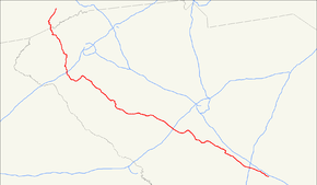
U.S. Highway 178 is a spur of U.S. Highway 78. It currently runs for 240.49 miles (387.03 km) from Dorchester, South Carolina at U.S. Highway 78 to Rosman, North Carolina at U.S. Highway 64. It passes through the states of South Carolina and North Carolina. It goes through the cities of Pickens, Anderson, North crossing the highway 321, Orangeburg, Harleyville, South Carolina and Bowman, South Carolina.
Route description
US 178 has a length of 6.35 miles (10.22 km) in North Carolina and spans 234.14 miles (376.81 km) in South Carolina.[1][2] The U.S. Highway is a part of the National Highway System from I-85 near Anderson to US 378 in Saluda.[3]
US 178 begins at an intersection with US 64 just west of the town of Rosman within Pisgah National Forest in southern Transylvania County, North Carolina. The two-lane road, which is named Pickens Highway, heads east into the town parallel to the French Broad River. US 178 turns south onto Chestnut Street, crosses the river to leave the town, and turns east again to parallel the river. The highway veers away from the mainstem of the French Broad to follow its Middle Fork south then east, then turns south and climbs to the Eastern Continental Divide at Eastatoe Gap between Burnt Mountain and Indian Camp Mountain.[4][5] US 178 enters Pickens County, South Carolina, and its name changes to Moorefield Memorial Highway shortly after it begins its curvaceous and steep descent along Eastatoe Creek to Rocky Bottom. There, the U.S. Highway meets the western end of F. Van Clayton Memorial Highway, which leads to the highest point in South Carolina, Sassafras Mountain.[4][6]
US 178 crosses another ridge into the valley of Reedy Cove Creek, then climbs again to Beasley Gap between Rich Mountain and Horse Mountain. From there, the highway has a sharp and curvy descent to the valley of the Oolenoy River, which it follows east to near its junction with SC 11 (Cherokee Foothills Scenic Highway) at the hamlet of Holly Springs. US 178 curves south at its intersection with SC 288 (Table Rock Road), has a short climb to Mosley Gap between Mosley Mountain and Walnut Cove Mountain, and follows several different creeks through the foothills, which the highway exits as it enters the town of Pickens. The highway expands to four lanes and enters the town on Ann Street and has a very brief concurrency with SC 183 (Main Street) in the center of town; SC 183 connects US 178 with SC 8. US 178 leaves the town along Pendleton Street and drops to two lanes again south of town. The highway passes Pickens County Airport on its way to Liberty. The U.S. Highway, which enters the town along Pickens Drive, intersects SC 93 (Main Street) in the center of the town and has a grade crossing of Norfolk Southern Railway's Greenville District as it leaves town along Anderson Drive. Just south of the town limits, US 178 has a diamond interchange with US 123 (Calhoun Memorial Highway).[4][6]
US 178 meets the southern end of SC 135 shortly before entering Anderson County, where the highway becomes Liberty Highway and intersects SC 88 (Old Greenville Highway). The highway crosses the Six and Twenty Creek arm of Lake Hartwell and temporarily expands to four lanes around its intersection with US 176 Connector, which feeds into SC 28's western bypass of Anderson, Pearman Dairy Road. US 178 gradually approaches US 76 and SC 28 Business (Clemson Boulevard) as it enters a commercial area before meeting and joining those highways at an oblique intersection. The three highways follow an undivided highway with three southbound lanes, two northbound lanes, and a center turn lane into the city of Anderson, where the road's name changes to Main Street and passes to the east of the Civic Center of Anderson. South of Anderson Mall, US 28 Business continues on Main Street while US 178 and US 76 veer onto four-lane North Avenue, which parallels Main Street on the west. Shortly after North Avenue splits into one-way carriageways split by a wide parked median, the avenue veers east toward Main Street and the U.S. Highways continue along Club Drive and Park Drive, which have several sports field in their wide median.
US 178 and US 76 enter downtown Anderson along four-lane Murray Avenue, which runs one block to the west of Main Street.
US 178 is signed north–south in North Carolina and east–west in South Carolina; which is why it is listed as having an northern and eastern terminus.
Future
NCDOT plans to modernize a 5.85-mile (9.41 km) section of US 178, between Rosman and the South Carolina state line. The project includes widening lanes to 12 feet (3.7 m), from the current 9 feet (2.7 m), adjust its alignment and add a climbing lane. At an estimated cost of $14.1 million, it is currently unfunded.[7]
Junction list
| State | County | Location | mi [1][2] | km | Destinations | Notes |
|---|---|---|---|---|---|---|
| North Carolina | Transylvania | Rosman | 0.00 | 0.00 | Western terminus | |
| 6.35 0.00 | 10.22 0.00 | North Carolina–South Carolina state line | ||||
| South Carolina | Pickens | Rocky Bottom | 3.31 | 5.33 | F. Van Clayton Memorial Highway – Sassafras Mountain | |
| | 10.46 | 16.83 | ||||
| | 10.69 | 17.20 | ||||
| Pickens | 19.14 | 30.80 | West end of concurrency with SC 183 | |||
| 19.16 | 30.84 | East end of concurrency with SC 183 | ||||
| Liberty | 26.02 | 41.88 | ||||
| 27.57 | 44.37 | Diamond interchange | ||||
| | 30.17 | 48.55 | ||||
| Anderson | | 33.14 | 53.33 | |||
| Northlake | 43.15 | 69.44 | I-85 Exit 21 | |||
| 44.49 | 71.60 | |||||
| Anderson | 45.28 | 72.87 | West end of concurrencies with US 76 and SC 28 Business | |||
| 46.52 | 74.87 | East end of concurrency with SC 28 Business | ||||
| 48.80 | 78.54 | West end of concurrency with US 29 Business and SC 81 | ||||
| 49.18 | 79.15 | |||||
| 49.43 | 79.55 | East end of concurrency with US 29 Business and SC 81 | ||||
| 49.51 | 79.68 | |||||
| 50.85 | 81.84 | West end of concurrency with US 29 | ||||
| 51.43 | 82.77 | East end of concurrency with US 29 | ||||
| | 54.78 | 88.16 | Eastbound exit, westbound entrance | |||
| | 58.01 | 93.36 | ||||
| Belton | 60.45 | 97.28 | West end of concurrency with SC 20 | |||
| 60.52 | 97.40 | East end of concurrency with SC 20 | ||||
| Honea Path | 68.73 | 110.61 | West end of concurrency with SC 252 | |||
| 68.79 | 110.71 | East end of concurrencies with US 76 and SC 252 | ||||
| Abbeville | Donalds | 74.39 | 119.72 | West end of concurrency with SC 184 | ||
| 74.44 | 119.80 | East end of concurrency with SC 184 | ||||
| Greenwood | | 77.42 | 124.60 | |||
| Hodges | 83.57 | 134.49 | ||||
| 84.14 | 135.41 | |||||
| 84.18 | 135.47 | West end of concurrency with US 25 | ||||
| Greenwood | 90.23 | 145.21 | West end of concurrency with SC 72 | |||
| 90.87 | 146.24 | |||||
| 92.39 | 148.69 | East end of concurrency with SC 72; west end of concurrency with US 221 | ||||
| 95.89 | 154.32 | Partial cloverleaf interchange | ||||
| 97.12 | 156.30 | East end of concurrency with US 221 | ||||
| | 98.29 | 158.18 | ||||
| | 98.83 | 159.05 | ||||
| | 99.97 | 160.89 | East end of concurrency with US 25 | |||
| | 104.41 | 168.03 | ||||
| | 110.65 | 178.07 | ||||
| Saluda | Saluda | 121.93 | 196.23 | West end of concurrency with SC 39 | ||
| 122.02 | 196.37 | West end of concurrency with SC 121 | ||||
| 122.37 | 196.94 | |||||
| 122.57 | 197.26 | East end of concurrency with SC 121 | ||||
| 124.04 | 199.62 | East end of concurrency with SC 121 | ||||
| Lexington | Batesburg-Leesville | 137.50 | 221.28 | West end of concurrency with SC 23 | ||
| 137.61 | 221.46 | East end of concurrency with SC 23; west end of concurrency with SC 391 | ||||
| 137.89 | 221.91 | |||||
| 138.27 | 222.52 | East end of concurrency with SC 391 | ||||
| 140.78 | 226.56 | |||||
| | 146.13 | 235.17 | I-20 Exit 39 | |||
| | 152.72 | 245.78 | ||||
| Pelion | 160.38 | 258.11 | ||||
| | 168.93 | 271.87 | ||||
| Orangeburg | North | 174.03 | 280.07 | |||
| 174.80 | 281.31 | |||||
| | 178.24 | 286.85 | ||||
| Orangeburg | 190.67 | 306.85 | ||||
| 191.75 | 308.59 | West end of concurrency with US 21 | ||||
| 192.84 | 310.35 | |||||
| 193.69 | 311.71 | |||||
| 194.79 | 313.48 | |||||
| 196.11 | 315.61 | East end of concurrency with US 21 | ||||
| Bowman | 209.55 | 337.24 | West end of concurrency with SC 210 | |||
| 209.67 | 337.43 | East end of concurrency with SC 210 | ||||
| Dorchester | | 218.29 | 351.30 | I-95 Exit 82 | ||
| | 220.95 | 355.58 | ||||
| Harleyville | 226.11 | 363.89 | ||||
| | 234.14 | 376.81 | Eastern terminus | |||
| 1.000 mi = 1.609 km; 1.000 km = 0.621 mi | ||||||
Bannered routes
Northlake connector
| |
|---|---|
| Location: | Northlake, South Carolina |
Greenwood business loop
| |
|---|---|
| Location: | Greenwood, South Carolina |
| Length: | 4.84 mi[2] (7.79 km) |
U.S. Route 178 Business is a business route of U.S. Route 178 in Greenwood and its western terminus of SC 34 along with US 25.[6][8]
Saluda connector
| |
|---|---|
| Location: | Saluda, South Carolina |
Orangeburg business loop
| |
|---|---|
| Location: | Orangeburg, South Carolina |
| Length: | 4.40 mi[2] (7.08 km) |
U.S. Route 178 Business is a business route of U.S. Route 178 in the city of Orangeburg.[6][9]
References
- 1 2 3 Statewide Primary & Secondary Road Arcs (ESRI shapefile) (Map). North Carolina Department of Transportation. 2012. Retrieved 2012-06-01.
- 1 2 3 4 5 Highways - Zipped Shapefile of roads maintained by SCDOT - Statewide (ESRI shapefile) (Map). South Carolina Department of Transportation. 2012. Retrieved 2012-06-01.
- ↑ National Highway System: South Carolina (PDF) (Map). Federal Highway Administration. December 2003. Retrieved 2012-06-11.
- 1 2 3 Google (2012-06-11). "U.S. Route 178" (Map). Google Maps. Google. Retrieved 2012-06-11.
- ↑ "NCDOT: State Mapping Resources". North Carolina Department of Transportation. Retrieved 2012-06-11.
- 1 2 3 4 "General County Highway Maps". South Carolina Department of Transportation. Retrieved 2012-06-11.
- Pickens County (PDF)
- Anderson County (PDF)
- Abbeville County (PDF)
- Greenwood County (PDF)
- Saluda County (PDF)
- Lexington County (PDF)
- Orangeburg County (PDF)
- Dorchester County (PDF)
- ↑ "SPOT ID: H090858" (PDF). North Carolina Department of Transportation. May 30, 2014. Retrieved July 10, 2014.
- ↑ Google (2012-06-11). "U.S. Route 178 Business (Greenwood, South Carolina)" (Map). Google Maps. Google. Retrieved 2012-06-11.
- ↑ Google (2012-06-11). "U.S. Route 178 Business (Orangeburg, South Carolina)" (Map). Google Maps. Google. Retrieved 2012-06-11.
External links
 Media related to U.S. Route 178 at Wikimedia Commons
- The Highways of South Carolina: US 178