U.S. Route 171
| |
|---|---|
 | |
| Route information | |
| Auxiliary route of US 71 | |
| Length: | 183 mi (295 km) |
| Existed: | 1930[1] – present |
| Major junctions | |
| South end: |
|
|
| |
| North end: |
|
| Location | |
| Parishes: | Calcasieu, Beauregard, Vernon, Sabine, DeSoto, Caddo |
| Highway system | |

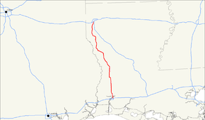
U.S. Route 171 (US 171) is a 183-mile-long (295 km) north–south United States highway. This short route, entirely within western Louisiana, has remained largely unchanged from its original 1926 route.
The highway's southern terminus is in Lake Charles at an intersection with U.S. Route 90.[2] Its northern terminus is in Shreveport, at an intersection with US 79/US 80. Here, the roadway continues as Louisiana Highway 3094.[3]
Route description
U.S. 171 is a major highway and is mostly divided, except through some towns. Beginning south to north from U.S. 90 the highway crosses I-10 then through Moss Bluff and the community of Gillis before entering Beauregard Parish. Next the community of Ragley, at the junction of U.S. Route 190 and Louisiana Highway 12. U.S. 171 continues north running concurrent with U.S. 190. The highway travels through the community of Longville before entering DeRidder. In DeRidder U.S. 171 crosses the Kansas City Southern Railroad tracks and passes through the DeRidder Commercial Historic District before splitting with U.S. 190. The old Sawmill community of Luddington is within the northern city limits. The northern city limits is also the Vernon Parish line. The old sawmill town of Midway is less than a mile north of DeRidder. About two miles north is the community of Rosepine. Two miles north of Rosepine is the site of the old Neame sawmill community. At a point in history this was a booming town with only two abandoned graves and a mill pond as memories. One graveyard, in a field south of a chip mill, is blocked by trees surrounding it or it would otherwise be in plain sight of the highway. U.S. 171 travels through the community of Pickering and the junction of LA 10, the main entrance to Fort Polk, Louisiana, New Llano, then into the city of Leesville. In Leesville U.S. 171 intersects with west Louisiana Highway 8 (to Texas) and runs concurrent with east LA 8 to the junction of LA 8/LA 28 east to Alexandria at the north Leesville city limits. A newly opened roundabout (traffic circle) completes the junction with LA 28, to hopefully correct several fatal car crashes at the intersection.
North of Leesville U.S. 171 goes through the communities of Hawthorn, Anacoco, and Hornbeck. Just north of Hornbeck is the Sabine Parish line and then Hodges Garden. U.S. 171 travels through the village of Florien the historic village of Fisher, where the annual sawmill days festival is held, the city of Many, the villages of Zwolle, Noble, then Converse. Just north of Converse U.S. 171 enters De Soto Parish then the village of Benson.
Four miles south of South Mansfield is the Mansfield State Historic Site that commemorates the 1864 Battle of Mansfield, and then Mansfield. North of Mansfield U.S. 171 runs through the village of Grand Cane, then the community of Kickapoo. Here U.S. 171 junctions with LA 5. To the west is the town of Keachi that has at least 10 buildings on the National Register of Historic Places. To the east is the unincorporated community of Gloster that has three buildings on the National register. About a mile north of the community of Stonewall U.S. 171 enters into Caddo Parish and travels through Keithville. On the south side of Shreveport, U.S. 171 junctions with the Inner Loop Expressway (Highway 3132). Through Shreveport to just north of East 70th Street (LA 511), it is called Mansfield Road, where Mansfield Road continues northeast and U.S. 171 continues north as Hearne Avenue. It junctions with U.S. 79 and U.S. 80 just north of I-20.
In a recent mistake found by the Louisiana DOTD, LA 3094, located at the northern terminus of US 171, was originally planned to be an extension north of the federal highway, and was the temporary designation. However, the routing for US 171 was never moved north. Once this mistake is fixed, US 171 will, in fact, meet US 71 once again.
History
US 171 began as a major two-lane highway. In 1962, I-210 was completed, and funds were appropriated for the highway to become four-laned. In the mid-1960s, the old iron bridge over the Calcasieu River, north of Lake Charles, was replaced and the highway was altered for the new bridge and portion of highway going into Moss Bluff. US 171 was designated a Blue Star Memorial Highway on Nov.11, 1964, and a highway marker was placed in the historic district at the junction with Washington street.[4] The TIMED Program widening of US 171 completed in July 2010 and it is now a four-lane divided highway for its entire rural existence.
Major intersections
The entire route is in Louisiana.
| Parish | Location | mi | km | Destinations | Notes |
|---|---|---|---|---|---|
| Calcasieu | Lake Charles | 0.0 | 0.0 | Southern terminus | |
| I-10 exit 33 | |||||
| | |||||
| Moss Bluff | |||||
| Beauregard | Ragley | Interchange; southern end of US 190 concurrency | |||
| Longville | |||||
| | |||||
| | |||||
| | |||||
| DeRidder | 1st Street is a one-way street; inbound access only | ||||
| One-way street; outbound access only; northern end of US 190 concurrency | |||||
| Vernon | | ||||
| Rosepine | |||||
| Pickering | |||||
| Leesville | |||||
| Southern end of LA 8 concurrency | |||||
| Northern end of LA 8 concurrency | |||||
| Anacoco | |||||
| Hornbeck | |||||
| Sabine | Florien | ||||
| Many | |||||
| | |||||
| | |||||
| Zwolle | |||||
| | |||||
| Noble | |||||
| Converse | |||||
| DeSoto | Benson | ||||
| Mansfield | |||||
| Grand Cane | |||||
| Kickapoo | |||||
| Stonewall | |||||
| Caddo | Shreveport | ||||
| I-20 exit 16A | |||||
| 183 | 295 | Northern terminus | |||
1.000 mi = 1.609 km; 1.000 km = 0.621 mi
| |||||
Zwolle business route
| |
|---|---|
| Location: | Zwolle |
| Length: | 3.12 mi (5.02 km) |
| Existed: | 2010–present |
U.S. Route 171 Business (US 171 Bus.) is a 3.12-mile (5.02 km) highway in Zwolle. It travels from west to east. US 171 Bus. follows the original routing of the US 171 mainline through Zwolle, connecting the former sections of US 171. As of 2012, it is still signed as north–south US 171.
The entire highway is in Zwolle, Sabine Parish.
| mi | km | Destinations | Notes | ||
|---|---|---|---|---|---|
| 0.0 | 0.0 | Southern terminus | |||
| 0.8 | 1.3 | ||||
| 1.5 | 2.4 | ||||
| 2.2 | 3.5 | ||||
| 3.1 | 5.0 | Northern terminus | |||
| 1.000 mi = 1.609 km; 1.000 km = 0.621 mi | |||||
See also
-
 Louisiana portal
 -
 U.S. Roads portal
 - List of U.S. Highways in Louisiana
Related routes
References
- ↑ Droz, Robert V. U.S. Highways : From US 1 to (US 830). URL accessed 19 March 2006.
- ↑ Calcasieu Parish, East Section (PDF) (Map). Cartography by DOTD Office of Multimodal Planning. Louisiana Department of Transportation and Development. February 2012. Retrieved January 31, 2014.
- ↑ Caddo Parish, South Section (PDF) (Map). Cartography by DOTD Office of Multimodal Planning. Louisiana Department of Transportation and Development. February 2012. Retrieved January 31, 2014.
- ↑ -Blue Star highway
External links
-
 Media related to U.S. Route 171 at Wikimedia Commons
 - Endpoints of US highways