U.S. Route 12 in Washington
| ||||
|---|---|---|---|---|
|
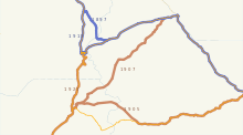
US 12 highlighted in red | ||||
| Route information | ||||
| Defined by RCW 47.17.055 | ||||
| Maintained by WSDOT | ||||
| Length: | 430.80 mi[1] (693.31 km) | |||
| Existed: | 1967 – present | |||
| Tourist routes: | Lewis and Clark Highway (from Clarkston to Pasco)[2] | |||
| Major junctions | ||||
| West end: |
| |||
|
| ||||
| East end: |
| |||
| Location | ||||
| Counties: | Grays Harbor, Thurston, Lewis, Yakima, Benton, Franklin, Walla Walla, Columbia, Garfield, Asotin, Nez Perce | |||
| Highway system | ||||
| ||||


U.S. Route 12 (US 12) is a major east-west U.S. Highway, running from Aberdeen, Washington, to Detroit, Michigan. It spans 430.80 miles (693.31 km) across the state of Washington, and is the only numbered highway to span the entire state from west to east, starting near the Pacific Ocean, and crossing the Idaho state line near Clarkston. It crosses the Cascade Range over White Pass, south of Mount Rainier National Park. Portions of it are concurrent with Interstate 5 (I-5) and Interstate 82 (I-82), although the majority of the route does not parallel any Interstate Highway.
Although US 12 was not extended into Washington until 1967, portions of it have been part of Washington's state highway system since as early as 1905. The last part of the highway to open was over White Pass in 1951, although it was added to the state highway system by the legislature in 1931. Most of the route (except for the approximately 160 miles (260 km) between Elma and Naches) had been part of the U.S. Highway System since its inception in 1926 as part of U.S. Route 410. The portion between Napavine and Grand Mound was also designated a U.S. Highway in 1926 as part of U.S. Route 99.
Route description

U.S. Route 12 begins in Aberdeen on a pair of one-way streets, Heron Street eastbound and Wishkah Street westbound.[3] At its western terminus, US 12 intersects US 101, which goes west along Heron and Wishkah, and south across Grays Harbor to the south side of Aberdeen.[3] The eastbound and westbound lanes of US 12 merge just east of the Wishkah River, near the Grays Harbor Historic Seaport.[4] US 12 then leaves Aberdeen to the east along the Chehalis River, where it passes through the towns of Central Park and Montesano.[5] Between Aberdeen and Elma, US 12 is four lanes wide. The majority of the highway in Washington, however, is a rural two-lane road.[1]
In the town of Elma, US 12 exits the highway at a diamond interchange. From there, the main highway continues east to Olympia as State Route 8 (SR 8), and US 12 heads southeast towards Oakville and Rochester.[6][7] East of Oakville, US 12 runs north of the Chehalis Indian Reservation.[8] It then continues east through the town of Rochester, and interchanges with I-5 at exit 88 in the town of Grand Mound.[9]

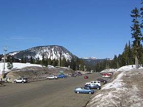
US 12 continues south concurrent with I-5 through Chehalis and Centralia before exiting again at exit 68 south of Napavine.[10] The highway then heads east along the Cowlitz River and passes through the town of Mossyrock, where it intersects SR 122. East of Mossyrock, US 12 runs just north of Mossyrock Dam and Riffe Lake. In the town of Morton, it intersects SR 7, which heads north to Tacoma.[11] It then ascends the Cascade Range, passing south of Mount Rainier, and intersects SR 123, which serves the Stevens Canyon entrance of Mount Rainier National Park.[12] Twelve miles (19 km) east of this intersection, US 12 crosses the Cascades over White Pass at an elevation of 4,500 feet (1,372 m).[1][13] White Pass is the only crossing of the Cascades open year-round between I-90 over Snoqualmie Pass and SR 14 through the Columbia River Gorge.[13][14]
After it descends the mountains, US 12 intersects SR 410 (formerly US 410) west of Naches, which serves Chinook Pass, Cayuse Pass, and the White River entrance of Mount Rainier National Park.[12] East of Naches, US 12 widens once again to four lanes as it approaches the city of Yakima.[1] There, it has an interchange with I-82 and US 97 at exit 31.[15] US 12 then runs concurrently with I-82, bypassing the towns of Toppenish and Prosser and paralleling the Yakima River, until exit 102 near the Tri-Cities. At exit 102, it meets the western terminus of Interstate 182. US 12 and I-182 then run concurrently east over Goose Gap and through the Tri-Cites. In Pasco, I-182 ends, and US 12 intersects US 395.[16]
US 12 then heads south to the town of Wallula, intersecting US 730, then east to Walla Walla, north to Dodge, and east to Clarkston before crossing the Idaho state line over the Snake River just outside Lewiston.[17] US 12 through Walla Walla consists of a four-lane bypass, also known as Inland Empire Highway.[1][18] The alignment of US 12 through Walla Walla County passes by a number of historical landmarks,[19] such as Whitman Mission and Fort Walla Walla.[17]
History
The Washington State Legislature created the State Highway Board in 1905 and appropriated funds to construct—but not maintain—twelve highways in sparsely settled areas of the state. Main highways in more populated areas would continue to be entirely under county control, though sometimes built with 50% state aid. Six of these highways were east-west crossings of the Cascades, including one in the corridor currently served by U.S. Route 12—State Road 5, the Cowlitz Pass State Road, climbing east from a point near Salkum via the Cowlitz River, over Cowlitz Pass, and down towards Yakima.[20][21] A 1907 amendment renamed State Road 5 the Cowlitz-Natches Road, moved the Cascade crossing north to Carlton Pass, and defined the portion east of the pass to follow the Bumping River and Naches River to a point near Naches. East of the mouth of the American River, this replaced part of State Road 1 (North Yakima and Natches State Road), which had been defined in 1897 to cross the Cascades north of Chinook Pass[22] and included in the 1905 appropriations.[20][23]
Under a 1909 law, the State Highway Board surveyed a connected network of proposed state roads. Included was a westerly extension of SR 5 via Chehalis to South Bend and Aberdeen and an easterly extension to Pullman. A route from Yakima southeast and east via the Tri-Cities to Idaho was also surveyed, mostly as an extension of State Road 8 (Columbia River Road).[24] The legislature added most of these routes to the state highway system in 1913, when they formed a two-tiered system of primary and secondary roads. Primary roads were completely controlled by the state, including maintenance, and received only names, while secondary roads kept their numbers and county maintenance. The National Park Highway replaced State Road 5 west of Riffe, and extended as surveyed to and beyond South Bend, and the McClellan Pass Highway replaced State Road 1 and continued via State Road 5 to Yakima. The majority of the route from Yakima via Connell to Pullman was not added at that time; it was finally taken over in 1937 as Secondary State Highways 11A and 11B. Only the route via the Tri-Cities, forming part of the Inland Empire Highway, continued from Yakima to Idaho. East of Pomeroy, the original survey had curved south, using State Road 16 to near the Oregon state line; this was bypassed by the 1913 designation, which instead continued directly east to Clarkston. Unlike the earlier state roads, these primary roads mostly followed existing passable county roads.[25] The incomplete roadway between Riffe and the American River remained as part of secondary State Road 5, and the legislature designated the surveyed route from the National Park Highway near Raymond north to Aberdeen as secondary State Road 20 in 1915.[21][26][27][28][29]
A 1923 restructuring of the system re-assigned numbers to almost all the primary state highways. State Road 5 became a primary route and was greatly expanded, taking over the entire McClellan Pass Highway and the National Park Highway east of the Pacific Highway. The former secondary State Road 5 was realigned starting from near Packwood, heading north instead of east, alongside the Ohanapecosh River to the old McClellan Pass Highway at Cayuse Pass, west of the summit of the Cascades. The new State Road 5, named the National Park Highway System, now included four roads in the vicinity of Mount Rainier National Park, but as the road across the Cascades at Chinook Pass was not yet built, these roads did not connect with each other.[30] Also included in this numbering was the designation of the Inland Empire Highway, including Yakima to Clarkston, as State Road 3.[31] In 1925, a spur was added to State Road 9—the Olympic Highway, looping around the Olympic Peninsula—connecting Elma to the Pacific Highway at Grand Mound, and creating a shortcut between the Cowlitz River route and Aberdeen.[32] The Olympic Highway from Elma west to Aberdeen had been added to the state highway system in 1905 west of and 1913 east of Montesano.[20][27]
As part of the U.S. Highway system laid out in 1925 and finalized in late 1926, U.S. Route 410 connected Aberdeen with Clarkston, following the Olympic Highway (State Road 9) to Olympia, the Pacific Highway (State Road 1)—concurrent with US 99—to Tacoma, the National Park Highway System (State Road 5) to Yakima, and the Inland Empire Highway (State Road 3) to Clarkston.[33] This differed from present US 12 between Elma and Naches in that it followed the route through Olympia and Tacoma rather than along the Cowlitz River. However, despite being part of the state highway system since 1897, US 410's crossing of the Cascades, the first between the Columbia River Gorge and Snoqualmie Pass, was not opened to traffic until 1931.[34] A shortcut from near Packwood east across White Pass to Naches, very close to the original plan for the east half of State Road 5, was added to the state highway system in 1931 as another branch of the highway.[35] The roadway between Packwood and Cayuse Pass, added to the state highway system on a different alignment in 1905, was finally completed in 1940,[36] and the White Pass Highway was dedicated on August 12, 1951, opening a shortcut between southwest Washington and Yakima.[37]

When the U.S. Highways were first established in 1926, US 12 ended in Miles City, Montana, and most of US 12's current routing in Washington was followed by US 410.[38] U.S. Route 12 was extended westward in stages; an extension to Lewiston, Idaho, was approved on June 19, 1962.[39] At various times in the early 1960s, the states of Idaho, Washington, and Oregon submitted plans for further westward extension to the American Association of State Highway Officials (AASHO) to either Vancouver, Washington or Boardman, Oregon—or, a plan submitted in 1963 had the highway going only as far as Pasco—but all of these plans were rejected.[39] Washington introduced a new system of sign route numbers in 1964. While US 410 was still signed as such, present US 12 became State Route 8 between US 410 at Elma and US 99/I-5 at Grand Mound and State Route 14 between US 99/I-5 at Chehalis and US 410 at Naches.[40] The extension of US 12 to Aberdeen was finally approved on June 20, 1967, with US 12 taking over much of US 410's former routing.[39] However, where US 410 had crossed the Cascades at Chinook Pass, US 12 used the all-weather White Pass, replacing SR 8 and SR 14.[41] Signs were changed in late December 1967,[42] and the bypassed segments of US 410 became a new SR 8 between Elma and Olympia, and SR 410 between Tacoma and Naches.[43][44]
Major intersections
| County | Location | mi[1] | km | Exit | Destinations | Notes |
|---|---|---|---|---|---|---|
| Grays Harbor | Aberdeen | 0.00 | 0.00 | |||
| | 9.41 | 15.14 | Devonshire Road | |||
| Montesano | 10.24 | 16.48 | ||||
| Elma | 20.19 | 32.49 | 3rd Street – Satsop Development Park | Interchange | ||
| 20.99 | 33.78 | Interchange | ||||
| Thurston | Rochester | 41.58 | 66.92 | Albany Street | Former SR 121 | |
| Grand Mound | 46.07 | 74.14 | Old Highway 99 – Grand Mound | Former US 99 south | ||
| 46.32 | 74.54 | 88 | West end of I-5 overlap; west end of freeway; former US 99 north | |||
| Lewis | Centralia | 51.92 | 83.56 | 82 | Harrison Avenue, Factory Outlet Way | |
| 52.98 | 85.26 | 81 | ||||
| Chehalis | 55.57 | 89.43 | 79 | Chamber Way | ||
| 56.68 | 91.22 | 77 | ||||
| 58.10 | 93.50 | 76 | 13th Street | |||
| Napavine | 61.87 | 99.57 | 72 | Rush Road | ||
| 63.60 | 102.35 | 71 | ||||
| | 66.24 | 106.60 | 68 | East end of I-5 overlap; east end of freeway | ||
| Mary's Corner | 68.86 | 110.82 | Jackson Highway – Lewis and Clark State Park | Former US 99 | ||
| Silver Creek | 79.98 | 128.72 | ||||
| Mossyrock | 86.59 | 139.35 | ||||
| Morton | 97.40 | 156.75 | ||||
| Randle | 114.72 | 184.62 | ||||
| | 138.34 | 222.64 | ||||
| Lewis–Yakima county line | | 150.79 | 242.67 | White Pass | ||
| Yakima | | 185.08 | 297.86 | |||
| | 199.06 | 320.36 | West end of freeway | |||
| Yakima | 199.64 | 321.29 | Fruitvale Boulevard, North 40th Avenue | |||
| 201.25 | 323.88 | North 16th Avenue | ||||
| 202.19 | 325.39 | North 1st Street | ||||
| 202.44 | 325.80 | 31 | West end of I-82/US 97 overlap | |||
| 203.72 | 327.86 | 33A | Fair Avenue, Lincoln Avenue | Eastbound exit only | ||
| 204.27 | 328.74 | 33B | Yakima Avenue – Terrace Heights | Signed as exit 33 westbound | ||
| 205.80 | 331.20 | 34 | ||||
| Union Gap | 207.32 | 333.65 | 36 | Valley Mall Boulevard – Union Gap | ||
| | 208.87 | 336.14 | 37 | East end of US 97 overlap; eastbound exit and westbound entrance | ||
| | 209.13 | 336.56 | 38 | Union Gap | Westbound exit and eastbound entrance | |
| | 211.37 | 340.17 | 40 | Thorp Road, Parker Road | ||
| | 215.35 | 346.57 | 44 | Wapato | ||
| | 221.14 | 355.89 | 50 | |||
| Zillah | 223.11 | 359.06 | 52 | |||
| 225.11 | 362.28 | 54 | Division Road – Zillah | |||
| Granger | 229.53 | 369.39 | 58 | |||
| Outlook | 234.67 | 377.66 | 63 | Sunnyside, Outlook | ||
| Sunnyside | 237.96 | 382.96 | 67 | Sunnyside, Mabton | ||
| 239.97 | 386.19 | 69 | ||||
| Grandview | 243.64 | 392.10 | 73 | Stover Road – Grandview | ||
| 246.08 | 396.03 | 75 | County Line Road – Grandview | |||
| Benton | Prosser | 250.96 | 403.88 | 80 | Gap Road – Prosser | |
| 253.37 | 407.76 | 82 | ||||
| | 259.58 | 417.75 | 88 | Gibbon Road | ||
| | 264.64 | 425.90 | 93 | Yakitat Road | ||
| Benton City | 267.61 | 430.68 | 96 | |||
| | 273.62 | 440.35 | 102 | East end of I-82 overlap; west end of I-182 overlap; exit 102 on I-82 eastbound, unnumbered exit on I-182 westbound | ||
| Richland | 276.55 | 445.06 | 3 | Queensgate Drive | Signed as exits 3A (south) and 3B (north) westbound | |
| 277.45 | 446.51 | 4 | West end of SR 240 overlap | |||
| 278.57 | 448.31 | 5 | East end of SR 240 overlap; signed as exits 5A (south) and 5B (north) | |||
| Columbia River | 279.66 | 450.07 | Interstate 182 Bridge | |||
| Franklin | Pasco | 280.93 | 452.11 | 7 | Broadmoor Boulevard | |
| 282.95 | 455.36 | 9 | Road 68 | |||
| 285.86 | 460.05 | 12A | West end of US 395 overlap | |||
| 286.30 | 460.76 | 12B | North 20th Avenue – Columbia Basin College | |||
| 287.38 | 462.49 | 13 | North 4th Avenue – Pasco City Center | |||
| 287.99 | 463.47 | 14 | East end of US 395 overlap; signed as exits 14A (south) and 14B (north) | |||
| 288.81 | 464.79 | East end of I-182 overlap | ||||
| 289.53 | 465.95 | East Lewis Street – Kahlotus | ||||
| 290.24 | 467.10 | East end of freeway | ||||
| Walla Walla | Burbank | 292.48 | 470.70 | Interchange[45] | ||
| | 304.64 | 490.27 | ||||
| Walla Walla | 332.48 | 535.07 | ||||
| 333.70 | 537.04 | 2nd Avenue – Walla Walla City Center | Interchange | |||
| 334.04 | 537.59 | Rees Avenue | No access across US 12 | |||
| 336.92 | 542.22 | Port of Walla Walla, Walla Walla Regional Airport | Interchange | |||
| 338.06 | 544.05 | Isaacs Avenue | Interchange | |||
| Waitsburg | 354.29 | 570.17 | ||||
| Columbia | | 369.37 | 594.44 | Turner Road | Former SR 126 east | |
| | 378.92 | 609.81 | ||||
| Garfield | | 387.50 | 623.62 | |||
| | 394.78 | 635.34 | Marengo Road | Former SR 126 west | ||
| Pomeroy | 400.64 | 644.77 | 15th Street | Former SR 128 east | ||
| Asotin | Clarkston | 429.24 | 690.79 | |||
| 430.62 | 693.02 | |||||
| 430.68 | 693.11 | 1st Street – Port of Clarkston | ||||
| Snake River | 430.81 | 693.32 | Washington–Idaho state line (Lewiston–Clarkston Bridge) | |||
| Nez Perce | Lewiston | Continuation into Idaho | ||||
1.000 mi = 1.609 km; 1.000 km = 0.621 mi
| ||||||
See also
References
- 1 2 3 4 5 6 Staff (2006). State Highway Log (PDF) (Report). Washington State Department of Transportation. Retrieved March 27, 2008.
- ↑ Scenic Highways: Interactive Map (Map). Washington State Department of Transportation. Retrieved September 5, 2012.
- 1 2 Google (October 30, 2015). "Aberdeen, WA" (Map). Google Maps. Google. Retrieved October 30, 2015.
- ↑ Port Angeles, Port Townsend, Sequim, Aberdeen, Hoquiam (Map). GM Johnson. 2006. § N37. ISBN 0-528-95736-8.
- ↑ The Road Atlas (Map). Rand McNally. 2008. p. 108. § H3. ISBN 0-528-93961-0.
- ↑ The Road Atlas (Map). Rand McNally. 2008. p. 108. § H4. ISBN 0-528-93961-0.
- ↑ Port Angeles, Port Townsend, Sequim, Aberdeen, Hoquiam (Map). GM Johnson. 2006. § C32. ISBN 0-528-95736-8.
- ↑ The Thomas Guide Pacific Northwest Road Atlas (Map) (7th ed.). Rand McNally. 2006. p. 117. § B1. ISBN 0-528-85869-6.
- ↑ The Road Atlas (Map). Rand McNally. 2008. p. 108. § I6. ISBN 0-528-93961-0.
- ↑ The Road Atlas (Map). Rand McNally. 2008. p. 108. § J6. ISBN 0-528-93961-0.
- ↑ The Road Atlas (Map). Rand McNally. 2008. p. 108. § J7. ISBN 0-528-93961-0.
- 1 2 U.S. National Park Service. "Mount Rainier National Park: Directions". Retrieved March 20, 2008.
- 1 2 The Road Atlas (Map). Rand McNally. 2008. p. 108. § I9. ISBN 0-528-93961-0.
- ↑ Staff (2007). "WSDOT: Mountain Passes". Washington State Department of Transportation. Retrieved April 18, 2008.
- ↑ The Road Atlas (Map). Rand McNally. 2008. p. 109. § J12, M20. ISBN 0-528-93961-0.
- ↑ The Road Atlas (Map). Rand McNally. 2008. p. 109. § K15. ISBN 0-528-93961-0.
- 1 2 The Road Atlas (Map). Rand McNally. 2008. p. 109. § K15, J20. ISBN 0-528-93961-0.
- ↑ The Thomas Guide Pacific Northwest Road Atlas (Map) (7th ed.). Rand McNally. 2006. p. 344–345. ISBN 0-528-85869-6.
- ↑ "A Highway Gain". Walla Walla Union-Bulletin. December 31, 1967. p. 4.
- 1 2 3 Washington State Legislature (1905). "An act providing for the survey establishment and repair of certain State highways, and making an appropriation therefor.". Session Laws of the State of Washington. Olympia, WA: State of Washington. 1905 chapter 7, p. 21.: "(5) For the building of a State wagon road in Yakima and Lewis Counties, as follows, to-wit: Beginning at a point in the center of the public highway running from the town of Napavine to Klickitat prairie in Lewis County, Washington, at the point nearest to the south-east corner of Section 10 in Township 12, north of Range 1, east of Willamette meridian, and running thence by way of Klickitat prairie and Riffe Postoffice in a generally easterly course up the Cowlitz river and its tributaries to the summit of the Cascade mountains at the Cowlitz pass, thence easterly towards the town of North Yakima to a point in Yakima County, intersecting with a public highway leading to the town of North Yakima, said road to be known and designated as the Cowlitz Pass State road, the sum of $26,000."
- 1 2 Staff. Forty Years with the Washington Department of Highways (PDF) (Report). Washington Department of Transportation. pp. 1–2, 6. Retrieved March 2008. Check date values in:
|access-date=(help) - ↑ Washington State Legislature (1897). "An act providing for the survey and establishment of a state road, creating a commission, defining their duties and making an appropriation therefor, and declaring an emergency.". Session Laws of the State of Washington. Olympia, WA: State of Washington. 1897 chapter 116, p. 342.
- ↑ Washington State Legislature (1907). "An act providing for the establishment, construction and maintenance of state roads and making appropriations for state roads heretofore established.". Session Laws of the State of Washington. Olympia, WA: State of Washington. 1907 chapter 151, p. 310.: "State Road No. 5, or the Cowlitz-Natches road: This road shall begin at a point in the center of the public highway running from the town of Napavine to Klickitat prairie in Lewis county, Washington, at the point nearest to the southeast corner of section 10, in township 12, north of range 1 east W. M., and shall run thence over the present surveyed line on such state road, by the way of Klicitat[sic] prairie and Riffe postoffice up the Cowlitz river and its tributaries, and over the summit of the Cascade mountains at the Carlton pass; thence over such surveyed line for said road down Bumping river and the Natches river to a point which bears south 73 degrees and 24 minutes east and is 2,356 feet (718 m) distant from the corner of sections 27, 28, 33 and 34, in township 15, north range 16, east W. M., in Yakima county, Washington."
- ↑ Washington State Legislature (1909). "An act providing for the survey of certain proposed state roads, and state road extensions, by the State Highway Commissioner, and a report on the feasibility of the same.". Session Laws of the State of Washington. Olympia, WA: State of Washington. 1909 chapter 51, p. 95.: "2nd. Extension over the most feasible route of State Road No. 5 westerly through the city of Chehalis to the cities of South Bend in Pacific county and Aberdeen in Chehalis county, and easterly to the city of Pullman in Whitman county." "3rd. Extension over the most feasible route of State Road No. 8 westerly to the city of Vancouver and easterly to the city of Walla Walla and thence to the eastern boundary of Asotin county." "6th. A road beginning at a point on the proposed extension of State Road No. 7 in the vicinity of Cle Elum in Kittitas county, leading thence as nearly as practicable along the Yakima valley to an intersection with the proposed extension of State Road No. 8 in Benton county."
- ↑ Road Map of Washington Showing Main Traveled Roads (Map). State Highway Board. 1912. Retrieved March 27, 2008.
- ↑ Map of the State of Washington Showing State Roads: Located and Proposed (Map). State Highway Board. 1909. Retrieved March 27, 2008.
- 1 2 Washington State Legislature (1913). "An act relating to public highways, classifying the same and naming and fixing the routes of certain state roads.". Session Laws of the State of Washington. Olympia, WA: State of Washington. 1913 chapter 65, p. 221-223.
- ↑ Washington State Legislature (1915). "An act relating to public highways, classifying the same, and naming and fixing the routes of certain state roads; amending sections 5878-2 and 5901 Remington & Ballinger's Annotated Codes and Statutes of Washington, and adding new sections to be known as sections 5878-2a, 5878-2b, 5878-2c, 5878-2d, 5878-2e, 5878-2f, 5878-2g, 5901a, 5901b, 5901c, 5901d, 5901e, 5901f, 5901g, 5901h, 5901i, 5901j, 5901k, 5901-L and declaring an emergency.". Session Laws of the State of Washington. Olympia, WA: State of Washington. 1915 chapter 164, p. 491.
- ↑ State of Washington Showing State Highways Authorized by Legislative Acts of 1915 (Map). State Highway Board. Retrieved March 27, 2008.
- ↑ Auto Road Atlas (Map). Rand McNally. 1926. Retrieved April 9, 2008.
- ↑ Washington State Legislature (1923). "An act relating to, classifying, naming and fixing the routes of certain state highways, amending Section 6796, and repealing Sections 6791, 6792, 6793, 6794, 6795, 6797, 6798, 6799, 6800, 6801, 6802, 6803, 6804, 6805, 6806, 6808, 6809, 6811, 6812, 6813 and 6816 of Remington's Compiled Statutes.". Session Laws of the State of Washington. Olympia, WA: State of Washington. 1923 chapter 185, p. 628-629.: "A primary state highway, to be known as State Road No. 5 or the National Park Highway System, is established as follows: Beginning at the City of Tacoma; thence by the most feasible route in a southeasterly direction through Elbe and Ashford to the Rainier National Park gate; also from a junction in the City of Elbe; thence in a southerly direction through Morton, Kosmos; thence in a westerly direction through Nesika, Riffe and Ethel to a junction with State Road No. 1 or the Pacific Highway at or in the vicinity of Jackson Prairie; also, from a junction at or near Kosmos in Lewis County in a northeasterly direction through Lewis in Lewis County through Sheepskull Gap; thence in a northwesterly direction through Enumclaw, Auburn, Kent to a connection with State Road No. 2 in the vicinity of Renton; also from a junction at Sheepskull Gap in a southeasterly direction to Yakima."
- ↑ Washington State Legislature (1925). "An act relating to and establishing, classifying, naming and fixing the routes of certain state highways, and amending sections 1, 2, 3, 4, 8, 14 and 15, Chapter 185 of the Laws of 1923, and Section 6810 of Remington's Compiled Statutes, and declaring that this act shall take effect immediately.". Session Laws of the State of Washington. Olympia, WA: State of Washington. 1925 chapter 26, p. 58-59.
- ↑ Bureau of Public Roads & American Association of State Highway Officials (November 11, 1926). United States System of Highways Adopted for Uniform Marking by the American Association of State Highway Officials (Map). 1:7,000,000. Washington, DC: U.S. Geological Survey. OCLC 32889555. Retrieved November 7, 2013 – via University of North Texas Libraries.
- ↑ "Chapter 8: The Park Under Construction". Mount Rainier: Administrative History. National Park Service. Retrieved March 2008. Check date values in:
|access-date=(help) - ↑ Highway Map: State of Washington (Map). Department of Highways. January 1931, with additions effective June 12, 1931. Retrieved March 27, 2008. Check date values in:
|date=(help) - ↑ "Chapter 11: The Impact of the New Deal". Mount Rainier: Administrative History. National Park Service. Retrieved March 2008. Check date values in:
|access-date=(help) - ↑ "White Pass Road Formal Dedication on August 12". Walla Walla Union-Bulletin. July 18, 1951. p. 7.
- ↑ Bureau of Public Roads & American Association of State Highway Officials (November 11, 1926). United States System of Highways Adopted for Uniform Marking by the American Association of State Highway Officials (Map). 1:7,000,000. Washington, DC: U.S. Geological Survey. OCLC 32889555. Retrieved November 7, 2013 – via University of North Texas Libraries.
- 1 2 3 Weingroff, Richard F. (May 7, 2005). "U.S. 12 Michigan to Washington". Federal Highway Administration. Retrieved March 20, 2008.
- ↑ Staff (December 1, 1965). "Identification of State Highways" (PDF). Washington State Highway Commission. Retrieved March 20, 2008.
- ↑ "All-Weather Plan Picked By Highway Commission". Walla Walla Union-Bulletin. April 23, 1967. p. 5.
- ↑ "Highway 410 is now U.S. No. 12". Walla Walla Union-Bulletin. December 28, 1967. p. 1.
- ↑ "U-B Action Line". Walla Walla Union-Bulletin. September 29, 1968. p. 1.
- ↑ Staff (1970). Annual Traffic Report (PDF) (Report). Washington State Highway Commission. Retrieved April 23, 2008.
- ↑ "US 12 - SR 124 Intersection — Build Interchange". Washington State Department of Transportation. Retrieved September 2, 2012.
External links
| Wikimedia Commons has media related to U.S. Route 12 in Washington (state). |
| Previous state: Terminus |
Washington | Next state: Idaho |