Uğurludağ
| Uğurludağ | |
|---|---|
 Uğurludağ | |
| Coordinates: 40°27′N 34°28′E / 40.450°N 34.467°ECoordinates: 40°27′N 34°28′E / 40.450°N 34.467°E | |
| Country | Turkey |
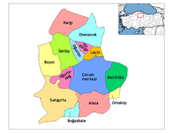
| Province | Çorum |
| Government | |
| • Mayor | Remzi Torun (MHP) |
| Area[1] | |
| • District | 549.11 km2 (212.01 sq mi) |
| Population (2012)[2] | |
| • Urban | 2,770 |
| • District | 6,521 |
| • District density | 12/km2 (31/sq mi) |
| Climate | Dsb[3] |
Uğurludağ is a small district of Çorum Province in the Black Sea region of Turkey. It is located at 66 km from the city of Çorum. Population is approximately 7,500. The mayor is Remzi Torun (MHP).
Name
Formerly known as Kızılören, renamed Uğurludağ after Urlu Mountain which stands behind the town. The name means 'lucky mountain' and is traditionally a place of healing. Other than some caves said to inhabit healing spirits there is little of historical or archaeological interest. But the mountain scenery, with the snow on the peak even in summer, does attract visitors.
Economy
Uğurludağ is a small market town in an agricultural district. The new generations are mostly migrating to larger cities in search of jobs and careers.
Uğurludağ was formerly within the district of İskilip and there is mutual dislike between the people of the two towns.
References
- ↑ "Area of regions (including lakes), km²". Regional Statistics Database. Turkish Statistical Institute. 2002. Retrieved 2013-03-05.
- ↑ "Population of province/district centers and towns/villages by districts - 2012". Address Based Population Registration System (ABPRS) Database. Turkish Statistical Institute. Retrieved 2013-02-27.
- ↑ Uğurludağ Climate-Data.org