Tychero
| Tychero Τυχερό | |
|---|---|
 Tychero | |
|
Location within the regional unit 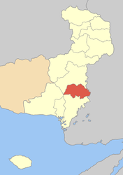 | |
| Coordinates: 41°01′N 26°17′E / 41.017°N 26.283°ECoordinates: 41°01′N 26°17′E / 41.017°N 26.283°E | |
| Country | Greece |
| Administrative region | East Macedonia and Thrace |
| Regional unit | Evros |
| Municipality | Soufli |
| Community[1] | |
| • Population | 2,311 (2011) |
| Time zone | EET (UTC+2) |
| • Summer (DST) | EEST (UTC+3) |
| Vehicle registration | EB |
Tycheró (Greek: Τυχερό, is a town and a former municipality in the Evros regional unit, East Macedonia and Thrace, Greece. Since the 2011 local government reform it is part of the municipality Soufli, of which it is a municipal unit.[2] Population 4,010 (2011). Tychero is situated near the river Evros, which forms the border with Turkey here. The Greek National Road 51/E85 (Alexandroupoli - Orestiada - Ormenio) passes west of the town. Tychero is located south of Soufli, south-southwest of Orestiada, northwest of İpsala (Turkey), north of Feres and northeast of Alexandroupoli.
Subdivisions
The municipal unit Tychero is subdivided into the following communities (constituent villages in brackets):
- Fylakto
- Lefkimmi
- Lyra
- Provatonas (Provatonas, Tavri, Thymaria)
- Tychero
Population
| Year | Community | Municipal Unit |
|---|---|---|
| 1991 | 1,961 | 4,053 |
| 2001 | 2,031 | 4,067 |
| 2011 | 2,311 | 4,010 |
History
Under Ottoman rule Tychero was known as Bıdıklı (Greek: Μπίντικλι). After the Balkan Wars (1912-1913) it became part of Bulgaria, and it became part of Greece in 1920. It was renamed to Tychio, which was changed to the current name Tychero in 1953.[3] In February 2006 Tychero was struck by a flood of the Evros river.
External links
References
- ↑ "Απογραφή Πληθυσμού - Κατοικιών 2011. ΜΟΝΙΜΟΣ Πληθυσμός" (in Greek). Hellenic Statistical Authority.
- ↑ Kallikratis law Greece Ministry of Interior (Greek)
- ↑ Name changes of settlements in Greece
 |
Soufli | Soufli | | |
| Alexandroupoli | |
İpsala (Turkey) | ||
| ||||
| | ||||
| Feres |