Twenty Mile Creek
| Twenty Mile Creek (Kenowchdaw) | |
| River | |
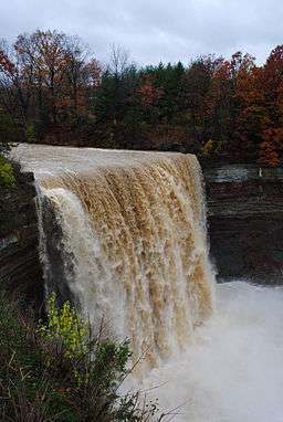 The Twenty Mile Creek flows over Ball's Falls as it crosses the Niagara Escarpment | |
| Name origin: English: named for the location of its mouth, twenty miles west of the Niagara River | |
| Country | Canada |
|---|---|
| Province | Ontario |
| Region | Southern Ontario |
| Counties | Lincoln, Wentworth |
| Part of | Great Lakes Basin |
| Source | Headwaters south of the City of Hamilton, near Hamilton International Airport |
| - elevation | 238 m (781 ft) |
| - coordinates | 43°11′7″N 79°54′34″W / 43.18528°N 79.90944°W |
| Mouth | Lake Ontario |
| - location | Jordan Harbor |
| - elevation | 74 m (243 ft) |
| - coordinates | 43°09′28″N 79°22′19″W / 43.15778°N 79.37194°WCoordinates: 43°09′28″N 79°22′19″W / 43.15778°N 79.37194°W |
| Length | 79 km (49 mi) |
| Basin | 291 km2 (112 sq mi) |
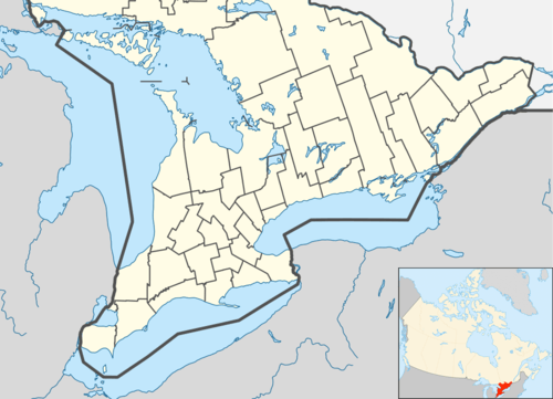 Location of the mouth of the Twenty Mile Creek in southern Ontario | |
The Twenty Mile Creek is a minor waterway, located in the Niagara Peninsula, Ontario, Canada.[1] The creek is named for the location of its mouth, twenty miles (30 km) west of the Niagara River along the Lake Ontario shoreline. The Indian name for the Twenty Mile Creek was the Kenowchdaw, which translates to Lead River.[2]
Watershed
The Twenty Mile Creek's watershed covers an area of 290 square kilometres (112 sq mi) and is about 79 kilometres (49 mi) in length. The creek begins at the headwaters above the Niagara escarpment in the City of Hamilton, rising near the Hamilton International Airport. From there the creek travels east above the escarpment, before turning north and crossing the Niagara Escarpment at Balls Falls (where it drops 25 metres (83 ft)). The creek eventually enters Lake Ontario at Jordan Harbour, after passing through the Jordan Marsh, which was created by lake waters flooding the lower reaches of the river valley. The Twenty Mile Creek watershed contains five sub-watersheds including the main channel of Twenty Mile Creek; Gavora Ditch, Spring Creek, North Creek and Sinkhole Creek.
The Twenty Mile Creek watershed contains several areas of natural and scientific interest, environmentally sensitive areas, and regionally significant wetlands. The upper reaches of the Twenty Mile Creek watershed are characterized by rolling topography with fairly steep slopes in the headwaters. Further downstream, the watershed contains gently rolling to flat topography before the creek flows over the Niagara Escarpment.
"Base flow in Twenty Mile Creek drops to zero during the summer months, although some water is retained in the channel pools. The low to non-existent summer flows may be due to a number of land use factors primarily resulting from agricultural expansion. These factors include a loss of water storage resulting from a decrease in the amount of forested areas, soil compaction, soil loss, and tile drainage. There may also be natural surface water losses via bedrock fractures and karst features."[3]
Navigation
Historically, the Twenty Mile Creek has been navigable by small craft and canoe as far upriver as Smithville, with the use of portages, most notably around the cataracts at Ball's Falls. In recent years, rafters, kayakers, and canoeis have navigated the rapids above and below Ball's Falls (Including Upper Ball's Falls (36")), although the 25-metre (83 ft) main cataract has yet to be attempted. The rapids rate a Class II to Class V (depending on river level) on the International Scale of River Difficulty.[4]
Settlements
The waterway played an essential role in the development of the communities on its banks. Smithville, St. Anns, and Jordan all owe their early activity to industry based upon the creek. The ghost town of Ball's Falls' development was also due to its location on the Twenty.[2]
Terror Plot
The Canadian National trestle bridge near Jordan was allegedly the subject of a terror plot in early 2013. The alleged plot involved an attempt by Chiheb Esseghaier and Raed Jaser, both non-citizen residents of Canada, to derail the daily New York-Toronto passenger train as it crossed the trestle. The two men were allegedly affiliates of an Al-Qaeda group operating out of Iran. [5][6][7]
References
- ↑ "Twenty Mile Creek". Geographical Names Data Base. Natural Resources Canada. Retrieved 2014-04-16.
- 1 2 Coffman, Barbara F; Powell, R Janet, eds. (1956). Lincoln County, 1856-1956. Saint Catharines, Ont: Lincoln County Council. OCLC 5724756.
- ↑ "Chapter 2: Niagara Peninsula Source Protection Area" (PDF). Updated Assessment Report - Niagara Peninsula Source Protection Area. Niagara Peninsula Source Protection Authority. 28 November 2013. p. 9. Retrieved 16 April 2014.
- ↑ Boyd, Geoff (16 December 2010). "Twenty Mile Creek". LiquidLore. Retrieved 16 April 2014.
- ↑ Rocha, Euan; Alastair Sharp (22 April 2013). "Canada thwarts "al Qaeda-supported" passenger train plot". Reuters Canada. Retrieved 23 April 2013.
- ↑ Macdonald, Alaistair; Siobhan Gorman; David George-Cosh (22 April 2012). "Canada Thwarts Alleged Plot to Attack Train". Wall Street Journal. Retrieved 23 April 2013.
- ↑ Moore, Amanda (13 January 2014). "Jordan train bridge reportedly target of thwarted terror plot". Grimsby Lincoln News. Retrieved 16 April 2014.