Tututepec
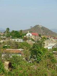
The Church in Modern-Day Tututepec, close to the archaeological site, with Mount Yuku Saa in the background.
Tututepec is a Mesoamerican archaeological site. It is located in the lower Río Verde valley on the coast of Oaxaca that formed the nucleus of an extensive Mixtec state during the Late Postclassic period (ca. 12th to early 16th centuries). At its largest extent the site covered some 21.85 km2, and its political influence extended over an area of more than 25,000 km² of the neighbouring territory.[1]
Its name in Mixtecan languages was Yucu Dzaa.[2]
Today, the site is occupied by the contemporary settlement of Villa de Tututepec de Melchor Ocampo, in the Mexican state of Oaxaca.
Notes
References
- Joyce, Arthur A.; Marc N. Levine. (2008). "Tututepec (Yucu Dzaa): Un Imperio del Posclásico en la Mixteca de la Costa". Arqueología Mexicana. XV (90): 44–47.
- Joyce, Arthur A.; Andrew G Workinger; Byron Hamann; Peter Kroefges; Maxine Oland; Stacie M. King (2004). "Lord 8 Deer "Jaguar Claw" and the Land of the Sky: The Archaeology and History of Tututepec". Latin American Antiquity. Society for American Archaeology. 15 (3): 273–297. doi:10.2307/4141575. JSTOR 4141575. Archived from the original on July 5, 2008.
- Joyce, Arthur A. (2010). Mixtecs, Zapotecs and Chatinos: Ancient peoples of Southern Mexico. Wiley Blackwell. ISBN 978-0-631-20977-5.
- Levine, Marc N. (2011). "Negotiating Political Economy at Late Postclassic Tututepec (Yucu Dzaa), Oaxaca, Mexico". American Anthropologist. 113 (1): 22–39. doi:10.1111/j.1548-1433.2010.01304.x.
Coordinates: 16°07′N 97°36′W / 16.117°N 97.600°W
This article is issued from Wikipedia - version of the 9/9/2016. The text is available under the Creative Commons Attribution/Share Alike but additional terms may apply for the media files.