Arcipelago Toscano National Park
| Parco Nazionale Arcipelago Toscano | |
|---|---|
|
IUCN category II (national park) | |
|
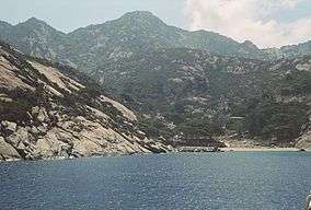
Montecristo Island, Tuscan Archipelago | |
 | |
| Location | Tuscan Archipelago |
| Nearest city | Portoferraio |
| Coordinates | 42°45′N 10°18′E / 42.750°N 10.300°E[1]Coordinates: 42°45′N 10°18′E / 42.750°N 10.300°E[2] |
| Area | 746.63 km2 (288.28 sq mi) |
| Established | 1996, expanded in 1997 |
| Governing body | Ministero dell`Ambiente |
| http://www.islepark.it/ | |
Arcipelago Toscano National Park is a large Tuscan Archipelago national park and marine park in the Provinces of Grosseto and Livorno, western Tuscany, Italy.
Geography
The Tuscan archipelago (chain of islands) is located between the Ligurian Sea (north) and Tyrrhenian Sea (south), in the Mediterranean Sea.
The Italian national park protects 56,776 hectares (140,300 acres) of sea and 17,887 hectares (44,200 acres) of island (land) habitats.[3]
The Arcipelago Toscano National Park includes the seven main islands (isola) of the Tuscan Archipelago:
- Elba
- Isola del Giglio
- Capraia
- Montecristo
- Pianosa
- Giannutri
- Gorgona
- and some of the minor islands and rock outcrops.
The highest point in the park is Mount Capanne (Italian: Monte Capanne), at 1,019 metres (3,343 ft) in elevation, on the island of Elba.
See also
Notes
- ↑ Google (15 January 2012). "Parco Nazionale Arcipelago Toscano" (Map). Google Maps. Google. Retrieved 15 January 2012.
- ↑ Google (15 January 2012). "Parco Nazionale Arcipelago Toscano" (Map). Google Maps. Google. Retrieved 15 January 2012.
- ↑ "Protected Area". Parco nazionale dell'Arcipelago Toscano. Retrieved 15 January 2012.
References
- Yearbook of the Italian Parks 2005; edited by Comunicazione in association with Federparchi and the Italian State Tourism Board; ISBN 88-7585-011-9.
External links
| Wikimedia Commons has media related to Arcipelago Toscano National Park. |
This article is issued from Wikipedia - version of the 11/19/2016. The text is available under the Creative Commons Attribution/Share Alike but additional terms may apply for the media files.