Turia (river)
| Turia | |
| Guadalaviar | |
| River | |
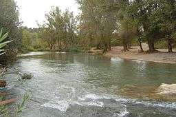 View of Turia River near Benaguasil | |
| Country | |
|---|---|
| Region | Aragon Castilla-La Mancha Valencian Community |
| District | Province of Teruel Province of Cuenca Province of Valencia |
| Source | |
| - location | Montes Universales, Aragon, Spain |
| - elevation | 1,680 m (5,512 ft) |
| Mouth | |
| - location | Mediterranean Sea in Valencia, Province of Valencia, Valencian Community, Spain |
| - elevation | 0 m (0 ft) |
| Length | 280 km (174 mi) |
| Basin | 6,393.6 km2 (2,469 sq mi) |
| Wikimedia Commons: Turia River | |


The Turia or Túria (Valencian: Riu Túria [ˈriw ˈtuɾia]; Spanish: Río Turia [ˈri.o ˈtuɾja]; Latin: Turia) is a Spanish river which has its source in the Montes Universales in the mountain ranges of the northwesternmost end of the Sistema Ibérico, Teruel province. From its source to roughly the city of Teruel, it is called Guadalaviar river. It runs through the provinces of Teruel, Cuenca and Valencia, and discharges into the Mediterranean sea near the city of Valencia.
Diversion Project
The river is famous for its floods. The flood which occurred on the 14th of October 1957, known as the Great Flood of Valencia, flooded large part of the city of Valencia, and produced a great deal of damage to both life and property. To prevent this from happening in the future, a diversion project was devised (Plan Sur de Valencia) and the river was divided in two at the western city limits. During floods, most of the water is diverted southwards along a new course that skirts the city, until it meets the Mediterranean.[1] The old course of the river has been turned into a central green-space for the city, a cultural attraction known as the garden of the Turia.
Not unlike the LA River man-made diversion channel south of the city is often found dry, since water primary flows during periods of flooding. Under ordinary flow rates the waters are directed through irrigation channels to help cultivate the fertile plain of Valencia. Throughout history the water of the River Turia has been used to irrigate the region. In modern times, a complex network of irrigation has been created, with the main axis centred on the diversion project.[2] Beyond irrigation, these channels also take runoff and surplus waters from the Turia to the wetlands and marshes around Valencia.
Attractions Along the old Course
The old riverbed is now a verdant sunken park that allows cyclists and pedestrians to traverse much of the city without the use of roads. The park, called the 'Garden of the Turia' (Jardí del Túria/Jardín del Turia) boasts numerous ponds, paths, fountains, flowers, football pitches, cafés, artworks, climbing walls, an athletics track, a zen garden and more. The many bridges overhead carry traffic across the park.
Towards the park's eastern end is the Gulliver Park (Parc Gulliver/Parque Gulliver), a children's adventure playground featuring a huge fibreglass model of Lemuel Gulliver tied to the ground with ropes. The model is constructed such that the ropes are climbable. In addition, Gulliver's clothes form slides and ladders on which to play. Also towards the eastern end of the river course is the Valencian Music Palace (el Palau de la Música Valenciana). Marking the park's eastern extreme is Valencia's new City of Arts and Sciences.
Two Metrovalencia stations lie beneath the riverbed, with entrances on either bank: Túria and Alameda.
See also
References
- ↑ Claudio Gómez Perretta (12 October 2007). "La importancia hidráulica y urbanística del Plan Sur". www.levante-emv.com. Retrieved 15 October 2011.
- ↑ Miquel Montañana Palacios y Santiago Tormo Esteve (2002). Grupo Español del IIC, ed. LOS AZUDES DEL TURIA EN LA VEGA DE VALENCIA. ASPECTOS FUNCIONALES, CONSTRUCTIVOS Y MORFOLÓGICOS DEL SISTEMA DE MESTALLA Y SU CONSERVACIÓN COMPATIBLE CON LOS USOS ACTUALES. (PDF). Actas del I Congreso del GEIIC. Conservación del Patrimonio: evolución y nuevas perspectivas. Retrieved 15 October 2011.
External links
Coordinates: 39°33′55.93″N 0°35′33.42″W / 39.5655361°N 0.5926167°W