Tuningen
| Tuningen | ||
|---|---|---|
| ||
 Tuningen | ||
Location of Tuningen within Schwarzwald-Baar-Kreis district 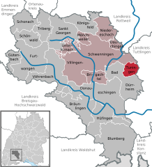
 | ||
| Coordinates: 48°01′36″N 8°36′07″E / 48.0268°N 08.6019°ECoordinates: 48°01′36″N 8°36′07″E / 48.0268°N 08.6019°E | ||
| Country | Germany | |
| State | Baden-Württemberg | |
| Admin. region | Freiburg | |
| District | Schwarzwald-Baar-Kreis | |
| Municipal assoc. | Villingen-Schwenningen | |
| Government | ||
| • Mayor | Jürgen Roth | |
| Area | ||
| • Total | 15.59 km2 (6.02 sq mi) | |
| Population (2015-12-31)[1] | ||
| • Total | 2,936 | |
| • Density | 190/km2 (490/sq mi) | |
| Time zone | CET/CEST (UTC+1/+2) | |
| Postal codes | 78609 | |
| Dialling codes | 07464 | |
| Vehicle registration | VS | |
| Website | www.tuningen.de | |

Tuningen (Low Alemannic: Doaninga) is a Gemeinde (municipality) located in the Schwarzwald-Baar district in the middle of Baden-Württemberg, Germany.
The municipality belongs to the administrative authority (Verwaltungsgemeinschaft) of Villingen-Schwenningen.
Geography
Tuningen is located at the east border of the Black Forest about 14 km south-east of the district town Villingen-Schwenningen, 6 km east of Bad Dürrheim and 5 km south-west of Trossingen.
History
The first explicit reference to Tuningen dates to 797, in a deed of donation by the cloister St. Gallen.
Twin towns
 Camogli, Italy, since 1998
References
External links
This article is issued from Wikipedia - version of the 11/30/2016. The text is available under the Creative Commons Attribution/Share Alike but additional terms may apply for the media files.