Tualatin, Oregon
| Tualatin, Oregon | ||
|---|---|---|
| City | ||
|
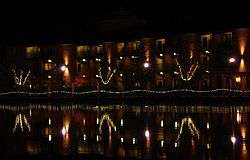
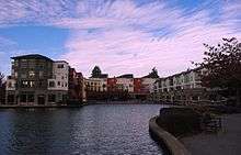
Tualatin Commons at night | ||
| ||
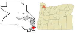 Location in Oregon | ||
| Coordinates: 45°22′29″N 122°46′12″W / 45.37472°N 122.77000°W | ||
| Country | United States | |
| State | Oregon | |
| Counties | Washington, Clackamas | |
| Incorporated | 1913 | |
| Government | ||
| • Mayor | Lou Ogden | |
| Area[1] | ||
| • Total | 8.23 sq mi (21.32 km2) | |
| • Land | 8.22 sq mi (21.29 km2) | |
| • Water | 0.01 sq mi (0.03 km2) | |
| Elevation | 123 ft (37.5 m) | |
| Population (2010)[2] | ||
| • Total | 26,054 | |
| • Estimate (2013[3]) | 26,879 | |
| • Density | 3,169.6/sq mi (1,223.8/km2) | |
| Time zone | Pacific (UTC-8) | |
| • Summer (DST) | Pacific (UTC-7) | |
| ZIP code | 97062 | |
| Area code(s) | 503/971 | |
| FIPS code | 41-74950 | |
| GNIS feature ID | 1128254[4] | |
| Website | www.ci.tualatin.or.us | |
Tualatin /tuːˈɔːlətᵻn/ is a city located primarily in Washington County in the State of Oregon. A small portion of the city is also located in neighboring Clackamas County. It is a southwestern suburb in the Portland Metropolitan Area that is located south of Tigard. The population was 26,054 at the 2010 census.
History
The name of the city is taken from the Tualatin River, which flows along most of the city's northern boundary. It is probably a Native American word meaning "lazy" or "sluggish" but possibly meaning "treeless plain" for the plain near the river or "forked" for its many tributaries.[5] According to Oregon Geographic Names, a post office with the spelling "Tualitin" was established November 5, 1869, and the spelling changed to "Tualatin" in 1915.
In the 1850s, the settlement was first called Galbreath after its founder Samuel Galbreath. In 1853, Galbreath built the first bridge over the Tualatin river, and the town became known as Bridgeport. In the 1880s, John Sweek platted a town around the new railroad depot, and named the town Tualatin. It was incorporated as the City of Tualatin in 1913.[6]
In 1962, a fossilized mastodon was excavated in what is now the Fred Meyer parking lot. It is now on display in the lobby of Tualatin Public Library.[7]
Demographics
| Historical population | |||
|---|---|---|---|
| Census | Pop. | %± | |
| 1920 | 234 | — | |
| 1930 | 198 | −15.4% | |
| 1940 | 180 | −9.1% | |
| 1950 | 248 | 37.8% | |
| 1960 | 359 | 44.8% | |
| 1970 | 750 | 108.9% | |
| 1980 | 7,348 | 879.7% | |
| 1990 | 15,013 | 104.3% | |
| 2000 | 22,791 | 51.8% | |
| 2010 | 26,054 | 14.3% | |
| Est. 2015 | 27,154 | [8] | 4.2% |
| U.S. Decennial Census[9] 2013 Estimate[10] | |||
2010 census
As of the census[2] of 2010, there were 26,054 people, 10,000 households, and 6,762 families residing in the city. The population density was 3,169.6 inhabitants per square mile (1,223.8/km2). There were 10,528 housing units at an average density of 1,280.8 per square mile (494.5/km2). The racial makeup of the city was 80.4% White, 1.2% African American, 0.7% Native American, 3.5% Asian, 1.0% Pacific Islander, 8.9% from other races, and 4.2% from two or more races. Hispanic or Latino of any race were 17.3% of the population.
There were 10,000 households of which 37.5% had children under the age of 18 living with them, 51.6% were married couples living together, 11.4% had a female householder with no husband present, 4.6% had a male householder with no wife present, and 32.4% were non-families. 24.6% of all households were made up of individuals and 5.3% had someone living alone who was 65 years of age or older. The average household size was 2.60 and the average family size was 3.12.
The median age in the city was 34.6 years. 26.9% of residents were under the age of 18; 8.5% were between the ages of 18 and 24; 31% were from 25 to 44; 26.8% were from 45 to 64; and 7% were 65 years of age or older. The gender makeup of the city was 49.1% male and 50.9% female.
2000 census
As of the census of 2000, there were 22,791 people, 8,651 households, and 5,804 families residing in the city. The population density was 2,928.5 people per square mile (1,131.1/km²). There were 9,218 housing units at an average density of 1,184.4 per square mile (457.5/km²). The racial makeup of the city was 86.89% White, 0.79% African American, 0.69% Native American, 3.62% Asian, 0.37% Pacific Islander, 4.84% from other races, and 2.81% from two or more races. Hispanic or Latino of any race were 11.85% of the population.
There were 8,651 households out of which 39.1% had children under the age of 18 living with them, 54.1% were married couples living together, 9.3% had a female householder with no husband present, and 32.9% were non-families. 24.5% of all households were made up of individuals and 4.6% had someone living alone who was 65 years of age or older. The average household size was 2.62 and the average family size was 3.17.
In the city the population was spread out with 28.2% under the age of 18, 9.4% from 18 to 24, 35.6% from 25 to 44, 21.0% from 45 to 64, and 5.8% who were 65 years of age or older. The median age was 32 years. For every 100 females there were 99.2 males. For every 100 females age 18 and over, there were 96.8 males.
The median income for a household in the city was $55,762, and the median income for a family was $68,165. Males had a median income of $47,004 versus $32,210 for females. The per capita income for the city was $26,694. About 3.0% of families and 5.5% of the population were below the poverty line, including 4.9% of those under age 18 and 3.8% of those age 65 or over.
Geography
According to the United States Census Bureau, the city has a total area of 8.23 square miles (21.32 km2), of which, 8.22 square miles (21.29 km2) is land and 0.01 square miles (0.03 km2) is water.[1]
Economy
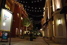

Tualatin is home to a majority of Bridgeport Village ("Bridgeport"), an upscale shopping area that opened in early 2005.[11] (The northern part of Bridgeport Village is in Tigard.) Built at the site of a former quarry, Bridgeport was designed to be reminiscent of an open-air European-style shopping experience. It features an 18-screen movie theater, several national and regional chain restaurants, and many chain retail stores.
There are many factories on the south side of town, including a large LAM Research plant that makes electrochemical deposition tools for manufacturing semiconductors.[12] Knife manufacturers Kershaw Knives and CRKT are located in Tualatin. Additionally, Al Mar Knives is headquartered in Tualatin, although manufacturing is done in Japan.
Oregon Scientific, a manufacturer of consumer electronics products, is headquartered in Tualatin.
From the 1960s through the 1980s, Tualatin was the home of Sunn Musical Equipment Company, a manufacturer of musical and sound reinforcement equipment.
Tualatin has been used as a filming location for Hollywood movies, including Thumbsucker, which was filmed at Tualatin High School.
See also
Education
The city of Tualatin falls incompletely under the jurisdiction of the Tigard-Tualatin School District. This district contains 10 elementary schools, three middle schools, and two high schools. Of these schools, five are actually located within Tualatin city limits: Bridgeport Elementary School, Byrom Elementary School, Tualatin Elementary School, Hazelbrook Middle School, and Tualatin High School. The city also includes Arbor School of Arts and Sciences, an independent K-8 school.
High schools
Middle schools
- Hazelbrook Middle School
Elementary schools
- Bridgeport Elementary
- Byrom Elementary
- Tualatin Elementary
- Deer Creek Elementary
A small section of the city is part of the West Linn-Wilsonville School District. Those students usually go to the same elementary, middle, and high schools: Stafford Primary, Athey Creek Middle School, and Wilsonville High School, respectively.
Weekend education
The Portland Japanese School, a weekend Japanese educational program for Japanese citizens and Japanese Americans, holds its classes at Hazelbrook Middle School at Tualatin.[13] The school began holding its classes there after the school opened in 1992.[14] The school office is in Beaverton.[13]
Media
- The Times, a weekly newspaper owned and operated by Portland-based Pamplin Media Group[15]
- Tualatin Life [16] a monthly newspaper focused exclusively on news, history and human interest stories in Tualatin, Oregon.
References
- 1 2 "US Gazetteer files 2010". United States Census Bureau. Retrieved 2012-12-21.
- 1 2 "American FactFinder". United States Census Bureau. Retrieved 2012-12-21.
- ↑ "Population Estimates". United States Census Bureau. Retrieved 2014-06-15.
- ↑ "US Board on Geographic Names". United States Geological Survey. 2007-10-25. Retrieved 2008-01-31.
- ↑ McArthur, Lewis A.; McArthur, Lewis L. (2003). Oregon Geographic Names (Seventh ed.). Portland, Oregon: Oregon Historical Society Press. p. 971. ISBN 0-87595-277-1.
- ↑ http://www.ci.tualatin.or.us/community/history.cfm
- ↑ Mastodon
- ↑ "Annual Estimates of the Resident Population for Incorporated Places: April 1, 2010 to July 1, 2015". Retrieved July 2, 2016.
- ↑ United States Census Bureau. "Census of Population and Housing". Retrieved September 25, 2013.
- ↑ "Annual Estimates of the Resident Population: April 1, 2010 to July 1, 2013". Retrieved June 15, 2014.
- ↑ Bridgeport Village
- ↑ http://www.shareholder.com/novellus/ReleaseDetail.cfm?ReleaseID=80249
- 1 2 "学校所在地・連絡先" (Archive). Portland Japanese School. Retrieved on April 9, 2015. "商工会事務局(月~金) 教育委員会事務局(火~金) Park Plaza West, Suite 600 10700 S.W. Beaverton-Hillsdale Hwy Beaverton, Oregon 97005" and "日本人学校(土) Hazelbrook Middle School 11300 S.W. Hazelbrook Rd. Tualatin, Oregon 97062"
- ↑ Florip, Eric. "Every weekend, Tualatin's Hazelbrook Middle School becomes Portland Japanese School, where it's all math and language" (Archive) The Oregonian. June 2, 2011. Retrieved on April 9, 2015.
- ↑
- ↑
External links
| Wikimedia Commons has media related to Tualatin, Oregon. |
- Tualatin Chamber of Commerce
- City of Tualatin (official website)
- Listing for Tualatin in the Oregon Blue Book
- "Tualatin, City of". The Oregon Encyclopedia.
- UnSprawl Case Study: Tualatin Commons
Coordinates: 45°22′29″N 122°46′12″W / 45.374808°N 122.770067°W
Municipalities and communities of Clackamas County, Oregon, United States | ||
|---|---|---|
| Cities | 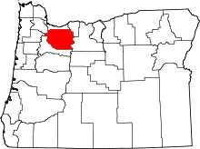 | |
| Hamlets | ||
| CDPs | ||
| Other unincorporated communities |
| |
| Footnotes | ‡This populated place also has portions in an adjacent county or counties | |
Municipalities and communities of Washington County, Oregon, United States | ||
|---|---|---|
| Cities |  | |
| CDPs | ||
| Unincorporated communities |
| |
| Ghost towns | ||
| Footnotes | ‡This populated place also has portions in an adjacent county or counties | |