Tsna River (Tver Oblast)
Coordinates: 57°31′46.7″N 34°22′5.9″E / 57.529639°N 34.368306°E
| Tsna River (Mstino Lake basin) | |
|---|---|
 | |
| Country | Russia |
| Basin | |
| Main source | Valdai Hills |
| River mouth | Lake Mstino |
| Basin size | 4,140 km2 (1,600 sq mi) |
| Physical characteristics | |
| Length | 160 km (99 mi) |
| Discharge |
|
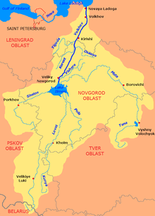
The Tsna (Russian: Цна) is a river in Kuvshinovsky, Ostashkovsky, Firovsky, and Vyshnevolotsky Districts of Tver Oblast of Russia. It is a tributary of Lake Mstino (technically, of Vyshny Volochyok Reservoir) and belongs to the drainage basin of the Neva and the Baltic Sea. It is 160 kilometres (99 mi) long, and the area of its basin 4,140 square kilometres (1,600 sq mi). The principal tributary of the Tsna is the Belaya River (right).[1] The source of the Tsna is located close to the drainage divide between Neva and Volga (Caspian Sea) drainage basins, and Tsna used to be an important trade route in the Middle Ages. The town of Vyshny Volochyok and the urban-type settlement of Velikooktyabrsky are located on the banks of the Tsna.
The source of the Tsna is located in the Valdai Hills, in Kuvshinovsky District south of the village of Konakovo. It flows south and southeast, and in the village of Mogilyovka turns north. A stretch of the Tsna forms a border between Kuvshinovsky and Ostashkovsky Districts, and a short stretch north of the first one forms the border between Kuvshinovsky and Firovsky Districts. North of this stretch, the Tsna enters Firovsky District and gradually turns northeast. Downstream of the village of Kuznetsovo the Tsna enters Vyshnevolotsky District. Its mouth is by the village of Nikiforovo, where the Tsna joins the Vyshny Volochyok Reservoir. The natural course of the Tsna proceeds to Lake Mstino, which is connected with the reservoir by a canal, however, currently the Vyshny Volochyok Reservoir regulates the discharge between the drainage basins of the Volga River (via the Tvertsa River) and the Neva River (via the Msta River, which flows out of Lake Mstino).
The drainage basin of the Tsna includes the western part of Vyshnevolotsky District, the southern part of Firovsky District, and the northwestern part of Kuvshinovsky District, as well as minor areas in the east of Ostashkovsky District.
Historically, the Tsna was one of the most important waterways in medieval Russia, providing a connection from the Baltic Sea basin into the Caspian Sea basin via the Tvertsa. In the beginning of the 18th century the portage located in Vyshny Volochyok was replaced by a system of canals, Vyshny Volochyok Waterway.[2]
References
- ↑ Река Цна (in Russian). State Water Register of Russia. Retrieved 27 December 2013.
- ↑ Медведев, Сергей Васильевич (2012). Визитная карточка Вышнего Волочка (in Russian). Ирида-Прос. Retrieved 16 January 2014.