Truden im Naturpark
| Truden im Naturpark | |
|---|---|
| Comune | |
| Comune di Trodena nel parco naturale Gemeinde Truden im Naturpark | |
 Truden im Naturpark Location of Truden im Naturpark in Italy | |
| Coordinates: 46°19′N 11°21′E / 46.317°N 11.350°ECoordinates: 46°19′N 11°21′E / 46.317°N 11.350°E | |
| Country | Italy |
| Region | Trentino-Alto Adige/Südtirol |
| Province / Metropolitan city | South Tyrol (BZ) |
| Frazioni | Kaltenbrunn (Fontanefredde), Mühlen (Molini di Trodena), San Lugano |
| Government | |
| • Mayor | Michael Epp |
| Area[1] | |
| • Total | 20.7 km2 (8.0 sq mi) |
| Elevation[1] | 1,127 m (3,698 ft) |
| Population (Nov. 2010)[1] | |
| • Total | 1,007 |
| • Density | 49/km2 (130/sq mi) |
| Demonym(s) |
German: Trudner Italian: trodenesi |
| Time zone | CET (UTC+1) |
| • Summer (DST) | CEST (UTC+2) |
| Postal code | 39040 |
| Dialing code | 0462 |
| Website | Official website |
Truden im Naturpark (German pronunciation: [ˈtruˑdn̩ ɪm naˈtuɐpark]; Italian: Trodena nel parco naturale [ˈtroːdena nel ˈparko natuˈraːle]) is a comune (municipality) in South Tyrol in northern Italy, located about 20 kilometres (12 mi) south of the city of Bolzano. Until March 2008 it was called simply Truden.[2]
Geography
As of November 30, 2010, it had a population of 1,007 and an area of 20.7 square kilometres (8.0 sq mi).[1]
Truden borders the following municipalities: Aldein, Altrei, Capriana, Carano, and Montan.
Frazioni
The municipality of Truden contains the frazioni (subdivisions, mainly villages and hamlets) Kltenbrunn (Fontanefredde), Mühlen (Molini di Trodena), and San Lugano.
History
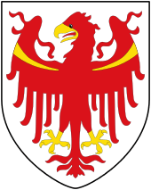
Coat-of-arms
The shield is barry of four of argent and gules and represents the crosier and the martyrdom hook, both of or in saltire with two palm branches on each side and a mitre over all. The emblem, granted in 1930, represents the insignia of Saint Blaise the patron saint.[3]
Society
Linguistic distribution
According to the 2011 census, 73.94% of the population speak German, 25.42% Italian and 0.64% Ladin as first language.[4]
Demographic evolution

References
- 1 2 3 4 See the file ‘Elenco dei comuni al 30 giugno 2009’, which can be downloaded in CSV and Excel formats from the Istat webpage Codici dei comuni, delle province e delle regioni.
- ↑ The new official designation was established by Regional law 22 February 2008 No. 1, published in the Official bulletin of the Trentino-AltoAdige/Südtirol Region X/I–II, 4 March 2008.
- ↑ Heraldry of the World: Truden im Naturpark
- ↑ "Volkszählung 2011/Censimento della popolazione 2011". astat info. Provincial Statistics Institute of the Autonomous Province of South Tyrol (38): 6–7. June 2012. Retrieved 2012-06-14.
External links
- (German) (Italian) Homepage of the municipality
![]() Media related to Truden im Naturpark at Wikimedia Commons
Media related to Truden im Naturpark at Wikimedia Commons