Troy, Pennsylvania
| Troy, Pennsylvania | |
|---|---|
| Borough | |
|
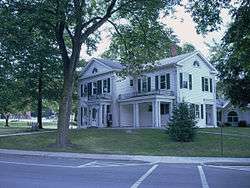
Troy Borough Hall | |
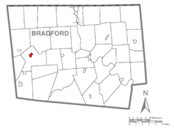 Map of Bradford County with Troy highlighted | |
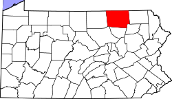
 Troy Location of Troy in the state of Pennsylvania | |
| Coordinates: 41°46′56″N 76°47′22″W / 41.78222°N 76.78944°WCoordinates: 41°46′56″N 76°47′22″W / 41.78222°N 76.78944°W | |
| Country | United States |
| State | Pennsylvania |
| County | Bradford |
| Area | |
| • Total | 0.8 sq mi (2.0 km2) |
| • Land | 0.8 sq mi (2.0 km2) |
| • Water | 0.0 sq mi (0.0 km2) |
| Elevation | 1,099 ft (335 m) |
| Population (2010) | |
| • Total | 1,354 |
| • Density | 1,767/sq mi (682.1/km2) |
| Time zone | Eastern (EST) (UTC-5) |
| • Summer (DST) | EDT (UTC-4) |
| Zip code | 16947 |
| Area code(s) | 570 |
| Website |
troyborough |
Troy is a borough in Bradford County, Pennsylvania, United States. The population was 1,354 at the 2010 census.[1] Children residing in the borough are assigned to attend the Troy Area School District.
History
The Troy Public High School and Van Dyne Civic Building are listed on the National Register of Historic Places.[2]
Geography
Troy is located in western Bradford County at 41°46′56″N 76°47′22″W / 41.78222°N 76.78944°W (41.782180, -76.789561).[3] It is surrounded by Troy Township but is separate from it. U.S. Route 6 passes through the borough, leading east 20 miles (32 km) to Towanda, the county seat, and west 17 miles (27 km) to Mansfield. Pennsylvania Route 14 turns south from US-6 in the center of Troy, leading 10 miles (16 km) to Canton; the highway turns north from US-6 just east of Troy and leads 25 miles (40 km) to Elmira, New York.
According to the United States Census Bureau, Troy has a total area of 0.77 square miles (2.0 km2), all of it land.[1]
Demographics
| Historical population | |||
|---|---|---|---|
| Census | Pop. | %± | |
| 1850 | 480 | — | |
| 1860 | 757 | 57.7% | |
| 1870 | 1,081 | 42.8% | |
| 1880 | 1,241 | 14.8% | |
| 1890 | 1,307 | 5.3% | |
| 1900 | 1,450 | 10.9% | |
| 1910 | 1,288 | −11.2% | |
| 1920 | 1,419 | 10.2% | |
| 1930 | 1,190 | −16.1% | |
| 1940 | 1,228 | 3.2% | |
| 1950 | 1,371 | 11.6% | |
| 1960 | 1,478 | 7.8% | |
| 1970 | 1,315 | −11.0% | |
| 1980 | 1,381 | 5.0% | |
| 1990 | 1,262 | −8.6% | |
| 2000 | 1,508 | 19.5% | |
| 2010 | 1,354 | −10.2% | |
| Est. 2015 | 1,269 | [4] | −6.3% |
| Sources:[5][6][7] | |||
As of the census[6] of 2010, there were 1,354 people, 571 households, and 327 families residing in the borough. The population density was 1,923.2 people per square mile (746.5/km²). There were 617 housing units at an average density of 786.9 per square mile (305.4/km²). The racial makeup of the borough was 98.34% White, 0.27% African American, 0.13% Native American, 0.73% Asian, 0.27% from other races, and 0.27% from two or more races. Hispanic or Latino of any race were 0.66% of the population.
There were 581 households, out of which 26.2% had children under the age of 18 living with them, 43.0% were married couples living together, 10.3% had a female householder with no husband present, and 43.7% were non-families. 37.2% of all households were made up of individuals, and 22.5% had someone living alone who was 65 years of age or older. The average household size was 2.30 and the average family size was 3.00.
In the borough the population was spread out, with 20.1% under the age of 18, 8.6% from 18 to 24, 28.6% from 25 to 44, 23.3% from 45 to 64, and 19.4% who were 65 years of age or older. The median age was 41 years. For every 100 females there were 70.2 males. For every 100 females age 18 and over, there were 63.3 males.
The median income for a household in the borough was $27,426, and the median income for a family was $41,667. Males had a median income of $30,625 versus $20,972 for females. The per capita income for the borough was $16,963. About 8.2% of families and 21.1% of the population were below the poverty line, including 13.0% of those under age 18 and 18.6% of those age 65 or over.
Notable people
- Pat Ballard, songwriter who composed "Mr. Sandman" and "(Oh Baby Mine) I Get So Lonely"
- Henry P. Davison, banker and first Chairman of the International League of Red Cross Societies
- Samuel M. Smead (1830–1898), newspaper editor and politician
References
| Wikimedia Commons has media related to Troy, Pennsylvania. |
- 1 2 "Geographic Identifiers: 2010 Demographic Profile Data (G001): Troy borough, Pennsylvania". U.S. Census Bureau, American Factfinder. Retrieved March 13, 2014.
- ↑ National Park Service (2010-07-09). "National Register Information System". National Register of Historic Places. National Park Service.
- ↑ "US Gazetteer files: 2010, 2000, and 1990". United States Census Bureau. 2011-02-12. Retrieved 2011-04-23.
- ↑ "Annual Estimates of the Resident Population for Incorporated Places: April 1, 2010 to July 1, 2015". Retrieved July 2, 2016.
- ↑ "Census of Population and Housing". U.S. Census Bureau. Retrieved 11 December 2013.
- 1 2 "American FactFinder". United States Census Bureau. Retrieved 2008-01-31.
- ↑ "Incorporated Places and Minor Civil Divisions Datasets: Subcounty Resident Population Estimates: April 1, 2010 to July 1, 2012". Population Estimates. U.S. Census Bureau. Retrieved 11 December 2013.