Tropical Storm Kim (1983)
| Tropical storm (JMA scale) | |
|---|---|
| Tropical storm (Saffir–Simpson scale) | |
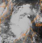 Tropical Storm Kim in the South China Sea | |
| Formed | October 14, 1983 |
| Dissipated | October 20, 1983 |
| Highest winds |
10-minute sustained: 75 km/h (45 mph) 1-minute sustained: 75 km/h (45 mph) |
| Lowest pressure | 994 hPa (mbar); 29.35 inHg |
| Fatalities | 200 direct |
| Areas affected | Thailand, Indochina |
| Part of the 1983 Pacific typhoon season 1983 North Indian cyclone season | |
Tropical Storm Kim was the only storm of 1983 to move from the Western Pacific basin into the North Indian Ocean basin as it moved across southern Indochina and into the Bay of Bengal as a tropical depression. Although Kim was a weak tropical storm, it still managed to cause 200 deaths and heavy crop damage in Indochina.
Meteorological history
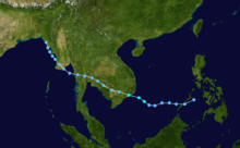
Tropical Storm Kim originated a weak tropical disturbance that formed to the northeast of Truk on October 9.[1] Over the next few days, the disturbance moved towards the west and was a persistent feature on satellite imagery; however, the disturbance showed no signs off developing and the Joint Typhoon Warning Center (JTWC) expected the disturbance to dissipate over the southern Philippines. On October 14, the disturbance moved into the Sulu Sea and subsequently it lost its convective signature and was no longer identifiable as a tropical disturbance, however the next day the system moved into the South China Sea and rapidly developed into a tropical depression. By this time, the monsoon trough was well developed in the South China Sea and provided a favorable environment aloft for further development.[1] By 1800 UTC on October 15, the Japan Meteorological Agency (JMA) first started monitoring the system.[2][nb 1]
Early on October 16, a Tropical Cyclone Formation Alert (TCFA) was then released as the JTWC expected Kim to intensify into a Tropical Storm within 24 hours.[1] The depression then intensified further and according to the Joint Typhoon Warning Center (JTWC), the depression attained tropical storm intensity at midday.[4] However, the tropical storm was named Kim until several hours later, when the JTWC initialized warnings on the system.[1] Simultaneously, the JMA upgraded Kim into a tropical storm, with winds of 75 km/h (45 mph), its peak intensity. Five hours later Kim made landfall on the coast of Vietnam while at peak intensity according to the JTWC.[4] The JTWC then stopped issuing advisories early the next day as Kim's atmospheric circulation had rapidly weakened over land, though intensity estimates from the JMA suggested that Kim was still a tropical storm.[1] Kim was then downgraded by the JTWC to a Tropical depression at 0600 UTC on October 17 whilst it crossed the border from Vietnam into Cambodia. After becoming even less organized, Kim was downgraded to a tropical disturbance by the JTWC.[1] On October 18, the JMA stopped watching the system.[2] Over the next couple of days the remnants of Kim moved across Indochina while producing a large amount of convection, while visual satellite imagery was showing indications that a mid to low level circulation center was apparent. Under than anticipation that the remnants of Kim would regenerate into the Andaman Sea, a TCFA was issued for the second time during the afternoon hours on October 18. Early the next day, the JTWC started to reissue warnings on Kim as it had regenerated into a tropical depression. Initially, Kim was expected to move across the southern tip of Burma and intensify further in the Bay of Bengal. Whilst Kim moved across southern Burma as expected, it never moved into the Bay of Bengal, instead Kim moved northwards along the coast of Burma, parallel to the Arakan Mountain Range and gradually weakened.[1] The JTWC issued their last warning on Kim at 1800 UTC on October 20 while located over the Arakan Mountains.[1][4]
Impact
Despite being weak, Kim's rapid development resulting in flooding to much of Southeast Asia, which were already suffering the effects of Tropical Storm Herbert, which had hit the region a few weeks previously.[1][5] Sixteen of Thailand's 73 provinces were flooded due to Kim and 18 people were killed in the country. Bankgkok, which at that time had a population of 6 million, was devastated and virtually every street and alley was flooded.[6] Many commuters were stranded on the tops of their cars. In addition, several airline flights were delayed or canceled. The road that connected the airport was flooded and hundreds of cars were abandoned. Many passengers were forced to walk through waist-deep water to reach safety. Numerous suburban residents temporarily abandoned their flooded homes and checked into hotels for short-term relief.[7] More than 510,000 acres of farmland were submerged in the central and northeastern part of the country. Over 250 provincial roads were damaged. Within the first two weeks of October, 15.7 in (400 mm) of rain fell on Bangkok, and Kim contributed the worst monsoon season in Thailand in 30 years,[6] which continued for four months after the storm.[8]
Damage from both Kim and Herbert totaled $26 million.[9] Due to Kim alone, over 200 people were killed,[5] including four that were electrocuted and "several" children that drowned due to flash flooding. A total of 190 bridges and at least 1,000 roads were damaged.[7] Due to a combination of the aforementioned flooding and Kim, 300 boats and ships, 3,000 houses, and 19,750 acres (8,000 hectares) of rice were destroyed.[8] Kim alone was responsible for the destruction of 200 thousand hectares of farmland.[5][8]
See also
References
- 1 2 3 4 5 6 7 8 9 Joint Typhoon Warning Center; Naval Western Oceanography Center (1984). Annual Tropical Cyclone Report: 1983 (PDF) (Report). United States Navy, United States Airforce. Retrieved September 30, 2013.
- 1 2 Japan Meteorological Agency (October 10, 1992). RSMC Best Track Data – 1980–1989 (.TXT) (Report). Retrieved October 6, 2013.
- ↑ "Annual Report on Activities of the RSMC Tokyo – Typhoon Center 2000" (PDF). Japan Meteorological Agency. February 2001. p. 3. Retrieved October 6, 2013.
- 1 2 3 "Tropical Storm 16W Best Track". Joint Typhoon Warning Center. 2002-12-17. Retrieved 2009-04-12.
- 1 2 3 Meteorological Results: 1983 (PDF) (Report). Hong Kong Royal Observatory. 1984. p. 11. Retrieved September 29, 2013.
- 1 2 "International News". Associated Press. October 19, 1983.
- 1 2 "Heavy floods in Thailand kill 21". United Press International. October 20, 1983.
- 1 2 3 Prasert Angsurattana & Veerasak Upomchoke (2003-04-15). "The Role of Agro environmental Education and Resources and related disasters in Thailand" (PDF). University of Tuskuba. p. 15. Retrieved 2009-04-13.
- ↑ "Foreign News Briefs". United Press International. October 20, 1983.
Notes
- ↑ The Japan Meteorological Agency is the official Regional Specialized Meteorological Center for the western Pacific Ocean.[3]