Trellech
| Trellech | |
| Welsh: Tryleg | |
 Trellech village, viewed from Beacon Hill |
|
 Trellech |
|
| Population | 2,759 (2011)[1] |
|---|---|
| OS grid reference | SO500054 |
| Community | Trellech United |
| Principal area | Monmouthshire |
| Ceremonial county | Gwent |
| Country | Wales |
| Sovereign state | United Kingdom |
| Post town | MONMOUTH |
| Postcode district | NP25 |
| Dialling code | 01600 |
| Police | Gwent |
| Fire | South Wales |
| Ambulance | Welsh |
| EU Parliament | Wales |
| UK Parliament | Monmouth |
|
|
Coordinates: 51°44′42″N 2°43′32″W / 51.74506°N 2.72560°W
Trellech (occasionally spelt Trelech, Treleck or Trelleck; modern Welsh: Tryleg) is a village and parish in Monmouthshire, south-east Wales, located on the B4293 road about 5 miles (8 km) south of Monmouth and 4 miles (6.4 km) north-north-west of Tintern. The name of the village derives from Welsh and means "the town (tre) of slates (llech)"; there are three standing stones close to the village, known as Harold's Stones. The church of St Nicholas is a Grade I listed building. The village is located on a plateau between the valleys of the Usk to the west and Wye to the east.
Although a relatively small village in modern times, it was one of the largest towns in Wales in the 13th century, and is now the location of archaeological investigations to determine its extent and role at that time. The village is designated as a Conservation Area,[2] and gives its name to the community of Trellech United, in which it is located. There are historically 26 known spellings of the village name; on each of the three roads entering the village, signs give a different spelling - Trellech, Trelleck and Trelech.
History
Trellech was one of the major towns of medieval Wales, the remains of which have been subject to archaeological excavations which have been sustained over many years and which continue today. It is most likely that the town was established by the De Clare family specifically for the exploitation of local supplies of iron ore from the Forest of Dean, and charcoal produced in the surrounding woodlands, to provide weapons, armour and iron work for their military advances in Wales, including the building of Caerphilly Castle.[3] By 1288 there were 378 burgage plots recorded in Trellech, which would have made it bigger than Cardiff or Chepstow at the time. Trellech was largely destroyed in 1291, however, as a result of a raid following a dispute over alleged deer poaching. The Black Death struck in 1340 and again in 1350. Subsequently the ravages of Owain Glyndŵr and his men in the early 15th century further reduced the prosperity and in consequence the importance of Trellech.
Archaeological investigations
Archaeological investigations at Trellech have been led since the early 1990s by the South Wales Centre for Historical and Interdisciplinary Research at the University of Wales, Newport.[4] There is currently some dispute over the layout and development of the medieval town and its environs.[5] In 2005, young archaeology graduate Stuart Wilson privately bought a field in which, he was convinced, were remains of the lost medieval town.[6] This site had first been identified as of potential interest by (the unrelated) Julia Wilson, in 1998.[7][8] Stuart Wilson's interest in this field and the possibility that his hunch might be correct was the subject of a 30-minute BBC Radio 4 documentary, presented by the archaeologist Francis Pryor, and entitled The Boy Who Bought a Field, broadcast on 6 March 2006. The programme revealed that Wilson had apparently discovered medieval walls and yard-paving. According to the Monmouth Archaeological Society, "there is now no room for debate"[9] that the excavations by Wilson and others have identified the main part of the medieval town to be around the minor road towards Catbrook, to the south of the current village, on what is now farmland. In 2016, Wilson proposed turning the site into a camp site, research centre and tourist attraction.[10]
Places of historical interest
Church of St Nicholas
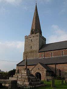
The Anglican parish church has been designated a Grade I listed building since 19 November 1953,[11] and is described by Joseph Bradney as "one of the largest and most handsome of the country churches in the county" of Monmouthshire.[12] With an elegant pointed and prominent steeple, a font and 17th-century sundial, it is a focal point of the village. The main part of the church building is of local Old Red Sandstone, with a three-stage tower. The spire can be seen for several miles around and is described by architectural writer John Newman as "the town's pride and joy".[13]
A church on this site, probably a wooden structure, was endowed by Ffernwael ap Ithel and Meurig ap Tewdrig who were rulers of Gwent in the 7th and 8th centuries. The Preaching Cross in the churchyard may date back to this time, as may the font. The present building dates from the 13th or early 14th century. The early English Gothic stonework has been dated to between 1225 and 1272, and that of the Decorated Gothic up to 1350. The church has a large clerestoried nave, with a much smaller chancel. The "impressive" interior has a "spendidly high" tower arch, and the five-bay nave has arcades on octagonal piers.[14] The altar rails and pulpit, dated 1640, are survivals of 17th century church interior design. At the west end of the church, directly below the window, is a Royal Coat of Arms for King Charles II dated 1683.[14] Records are held by the church dating from 1692. Complete lists of vicars, from 1359, and churchwardens, from 1763, can be found in the entrance to the south aisle. The rear of the main church door is inscribed "IHS 1595".
When the weathercock was removed from the spire in 1972 it was found to have been made in Ross-on-Wye in 1792. The original spire fell, damaging the roof of the nave, and a contemporary reference attributes this to "lightning and storms". In the belfry the cage housing the three bells is of a type similar to that found in others constructed about the year 1700. At the end of the last century the church was in a neglected state and was extensively renovated and re-roofed. The Belgian slates then in place were replaced with Welsh slates in 1961. The chancel was replastered in 1972 and painted white. During 1974 considerable repairs were undertaken to the north and south aisles, and in 2001 the majority of the churchyard dry-stone wall was removed and rebuilt.
Sundial
The church contains a stone sundial, dated 1689, which was originally set up by Lady Magdalen Probert of the Argoed, Penallt. Three of the four faces of the sundial show the village's historic features: Tump Terret, with the inscriptions MAGNA MOLE ("Great in its Mound") and O QUOT HIC SEPULTI ("Oh! How many are buried here"); Harold's Stones with the inscriptions MAIOR SAXIS ("Greater in its Stones") and HIC FUIT VICTOR HARALDUS ("Here Harold was victorious"); and the Virtuous Well, with the inscriptions MAXIMA FONTE ("Greatest in its Well") and DOM. MAGD. PROBERT OSTENDIT ("Lady Magdalen Probert gives proof of it"). The sundial stood in the garden belonging to the former village school, on top of the inverted ancient font, until both were moved inside the church in the early 20th century.[12] A carved wooden replica of the sundial was placed in a field south of the village in recent years.[14]
Harold's Stones

Three large monoliths of conglomerate stone, commonly referred to as pudding stone, are located in a field on the eastern side of the B4293 to the south of the village. (SO 498051)[15] The stones, situated on publicly accessible land belonging to the Davies family of Crosshands Farm, are a scheduled ancient monument.[16] The stones have been described as "one of the more substantial megalithic monuments in Monmouthshire".[17]
The stones are on slightly elevated ground close to running water and springs, which might be relevant to the choice of site.[18] They are believed to date back to the Bronze Age. Such remains are rare in this part of Wales. They derive their name from a legend that they mark the spot at which three chieftains fell in battle with Harold Godwinson, who defeated the Welsh in Gwent in 1063. In another legend the stones were flung from Skirrid by the mythical Jack o' Kent in a competition with the Devil.[19][20][21]
The stones form an approximate line running between north-east and south-west at an azimuth of about 229°, which probably indicates the midwinter sunset,[22] though the midsummer sunrise cannot be excluded on account of the lack of precise alignment of the stones.[23] They have been described as "the most visually impressive of the alignments in South Wales."[23] Their location, without good views beyond the immediate surroundings, suggests that its alignment may be significant.[24] The stones are respectively 2.7 metres (8 ft 10 in), 3.7 metres (12 ft), and 4.6 metres (15 ft) high, the tallest being at the south-west; the overall length of the row is 11 metres (36 ft).[19][25] The central stone has what are thought to be cup marks.[14] It is supposed that the stones were dragged to the site on logs and levered into position, probably either for seasonal information or for use at religious ceremonies. Houlder (1978) speculates that they were once part of a much larger and impressive alignment,[26] but Castleden (1992) suggests that they did not form part of a stone circle[27][17]
Aubrey Burl asserts that short stone-rows of this kind were used as the ritual centres of families of "perhaps ten or twenty adults and children", though the erection of large stones required the co-operation of several such families. He compared the Trellech stones to the row at Le Vieux-Moulin, Plouharnel, near Carnac, and says that "Similar short rows were erected by communities in Ireland, Britain and Brittany in the centuries of the Bronze age between 1800 and 1000 BC".[25] The source of the Trellech stones may have been the nearby Beacon Hill where there are outcrops of a similar conglomerate. A fourth stone, on nearby common land, is believed to have been destroyed in the 18th century.[17]
Tump Terret and Court Farm

Tump Terret is situated within the grounds of Court Farm to the south-west of the church. It dates back to Norman times, as the site of a small motte and bailey castle; traces of its surrounding ditch remain.[14] The castle was still extant in 1263, when it was mentioned in manorial documents. A local myth, commemorated on the sundial, was that it was a burial mound for those killed in actions between the forces of Harold Godwinson and the opposing Welsh. A now-vanished summer house was built by the Rumsey family on top of the mound.[12]
Trellech Court - now the site of the farmhouse - was the seat of a branch of the Seymour family until it passed to John Rumsey in the early 18th century. The existing building is, according to Bradney, "a building of no architectural features", and dates from around the time of Rumsey's ownership. It was converted into a farmhouse in the later 19th century.[12]
The Virtuous Well

Sometimes known as St Anne's Well, this circular wellspring, surrounded by a stone wall and seating, is located in a field on the left of the road to Tintern, about 400 yards (370 m) east of the village. Local tradition is that it is the only one remaining of originally nine holy wells in Trellech. In the 17th century, it was reportedly much frequented, and reputed to cure "the scurvy, colic and other distempers".[14] Water from the well is rich in chalybeate.[12]
It is a clootie well, where token offerings are placed around and within the well, and strips of cloth and ribbons are hung from neighbouring trees. It is also used as a wishing well. Traditionally, "to make a wish one threw into the water a small metal object. Many bubbles arising from it meant a rapid granting of one's wish, few bubbles meant that a long period of time would elapse before the wish came true and no bubbles at all meant that one's wish had not been granted. The young maidens of Trellech anxious to know how long they had to wait until their wedding day, would drop a pebble into the water and every bubble that arose counted for one month."[28]
The Village Hall / The Babington Centre
The building now known as the Trellech Village Hall, previously The Babington Centre was constructed in 1820 as a primary school. A school was first established in the village in 1591 by the epigrammatist John Owen, and a century later, in 1691, a new school was set up by the local vicar, Zachary Babington, a relative of the bishop of Llandaff, Gervase Babington.[12] Babington established a charity to enable poor children in the village to be educated.[29]
When Trellech Primary School moved to a new site on the north side of the village, the 1820 school building was claimed by the Diocese of Monmouth, but eventually passed to the Trellech Babington Educational Trust, a registered charity established in 1992.[29] The Babington Centre is now the main asset owned by the Babington Educational Foundation. The Centre is a focus for many aspects of village life including film nights, concerts, educational classes, private parties and other social events. It is the home of the Busy Bodies playgroup and Trellech Teas. Trellech teas provide a pop up tea shop every Friday afternoon.
The Lion Inn
Built in the late 16th century and completed in 1580, the Lion Inn was originally a coaching inn, brew house and pig farm. Many of the original features of the brewing cellar still remain, as do a number of outhouses that were used as pigsties. The Lion Inn has won CAMRA awards for its real ales. The inn has activities including an annual beer festival, a cider and perry festival, the entering of a team in the Monmouth raft race and a Burns Night celebration. Alternate Mondays feature 'Open Mic' evenings with musicians travelling from Cardiff and Bristol to participate in music ranging from rock to folk.
Notable people
Philosopher, logician and mathematician Bertrand Russell (1872–1970) was born at "Ravenscroft", the country home of his parents Lord and Lady Amberley, situated between Trellech and Llandogo. The property is now called "Cleddon Hall". International drug smuggler and author Howard Marks lived in Trellech during the 1970s at the height of his drug trafficking career.
References
- ↑ "Community and Ward population 2011.Retrieved 4 April 2015".
- ↑ Adopted Unitary Development Plan Archived July 12, 2010, at the Wayback Machine.
- ↑ Lost and found city: the rediscovery of a lost city in Wales reminds us that self-reliance and perseverance are keys to success - article in New American, Jan 8 2007, by Dennis Behreandt
- ↑ "South Wales Centre for Historical and Interdisciplinary Research". Timezone.newport.ac.uk. Retrieved 2012-09-06.
- ↑ "Interview with Stuart Wilson". Archaeology.org. Retrieved 2012-09-06.
- ↑ "Unearthed by moles...Britain's lost city", The Mail on Sunday, 26 February 2006
- ↑ John Greeves, "Trellech -The City Time Forgot", Cambria, 2014. Retrieved 13 February 2015
- ↑ "Summary of Results of 2005 Season", The Lost City of Trellech Project. Retrieved 13 February 2015
- ↑ Stephen Clarke, Down the Dig: Monmouth, an adventure in archaeology, 2008, Monmouth Archaeological Society, ISBN 978-0-9558242-1-0
- ↑ Max Evans, "Lost City of Trellech: Man spent life savings on field", BBC News, 19 November 2016. Retrieved 20 November 2016
- ↑ "Church of St Nicholas - Trellech United - Monmouthshire - Wales". British Listed Buildings. Retrieved 2012-09-06.
- 1 2 3 4 5 6 Bradney, Sir Joseph (1933). A History of Monmouthshire: The Hundred of Trelech. Mitchell Hughes and Clarke. pp. 129–154. ISBN 1 873361 16 5.
- ↑ Newman, John. The Buildings of Wales: Gwent/Monmouthshire. pp. 566–9, 574–5, 576–579.
- 1 2 3 4 5 6 Newman, John. The Buildings of Wales: Gwent. p. 578.
- ↑ "Photo of "Harold's Stones"". Geograph.org.uk. Retrieved 2012-09-06.
- ↑ "HAROLD'S STONES, TRELLECH;HAROLDS STONES;HAROLD STONES". Comisiwn Brenhinol Henebion Cymru. 2013.
- 1 2 3 Children, George; Nash, George (1996). A Guide To Prehistoric Sites In Monmouthshire. Logaston Press. pp. 41–44. ISBN 1-873827-49-0.
- ↑ Burgess, Colin (1980). The Age of Stonehenge. J M Dent. p. 350. ISBN 0-460-04254-8.
- 1 2 "Stones of Wales - Harold's Stones standing stones". Stonepages.com. Retrieved 18 May 2015.
- ↑ Hando, F., (1944), The Pleasant Land of Gwent, Newport: R. H. Johns
- ↑ "John's Homepage". jlb2011.co.uk. Retrieved 7 February 2015.
- ↑ Burl, Aubrey (1993). From Carnac to Callanish. Yale University Press. pp. 159–60. ISBN 0-300-05575-7.
- 1 2 Powell, Martin J. "Archaeoastronomy in South Wales: Stone Rows & Stone Pairs". Aenigmatis.com. Retrieved 2016-10-04.
- ↑ "The Prehistoric Funerary and Ritual Monument Survey of Glamorgan and Gwent" (PDF). Glamorgan-Gwent Archaeological Trust. p. 53.
- 1 2 Burl, Aubrey (1993). From Carnac to Callanish. Yale University Press. pp. 4–5. ISBN 0-300-05575-7.
- ↑ C. H. Houlder (1978). Wales: An Archaeological Guide. London: Faber and Faber. ISBN 978-0571082216.
- ↑ R. Castleden (1992). Neolithic Britain: New Stone Age Sites of England, Scotland and Wales. London: Routledge. ISBN 978-0415058452.
- ↑ Stephanie Poultner, "Wells and Springs around Trellech", Living Spring Journal, 2000. Retrieved 13 February 2015
- 1 2 History of The Babington Centre. Retrieved 13 February 2015
External links
| Wikimedia Commons has media related to Trellech. |
- Genuki info on Trellech with links
- Kelly's 1901 Directory of Monmouthshire on Trellech
- Castle Wales website on Trellech castle site
- Lost City of Trellech project
- The Babington Centre (Trellech Village Hall) website
- The Lion Inn website
- Trellech Primary School website