Traverse (surveying)
Traverse is a method in the field of surveying to establish control networks.[1] It is also used in geodesy. Traverse networks involve placing survey stations along a line or path of travel, and then using the previously surveyed points as a base for observing the next point. Traverse networks have many advantages, including:
- Less reconnaissance and organization needed;
- While in other systems, which may require the survey to be performed along a rigid polygon shape, the traverse can change to any shape and thus can accommodate a great deal of different terrains;
- Only a few observations need to be taken at each station, whereas in other survey networks a great deal of angular and linear observations need to be made and considered;
- Traverse networks are free of the strength of figure considerations that happen in triangular systems;
- Scale error does not add up as the traverse is performed. Azimuth swing errors can also be reduced by increasing the distance between stations.
The traverse is more accurate than triangulateration[2] (a combined function of the triangulation and trilateration practice).[3]
Types
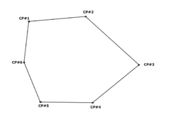
Frequently in surveying engineering and geodetic science, control points (CP) are setting/observing distance and direction (bearings, angles, azimuths, and elevation). The CP throughout the control network may consist of monuments, benchmarks, vertical control, etc.

Compound
A compound traverse is where an open traverse is linked at its ends to an existing traverse to form a closed traverse. The closing line may be defined by coordinates at the end points which have been determined by previous survey. The difficulty is, where there is linear misclosure, it is not known whether the error is in the new survey or the previous survey.
Notes
Usages
- Control point — The primary/base control used for preliminary measurements; it may consist of any known point capable of establishing accurate control of distance and direction (i.e. coordinates, elevation, bearings, etc.).
- Starting – The initial starting control point of the traverse.
- Observation – All known control points that are setted or observed within the traverse.
- Terminal – The initial ending control point of the traverse; its coordinates are unknown.