Transport in Auckland

Transport in Auckland, New Zealand's largest city, is defined by various factors, among them the shape of the Auckland isthmus (with its large lengths of coastline and assorted chokepoints,[1] and thus often long distances for land transport), the suburban character of much of the Auckland area, a history (since World War II) of focusing investment on roading projects rather than public transport[2] and the high car-ownership ratio of New Zealanders.
These factors have resulted in a mostly motor vehicle-based transport system, which uses several major motorways as its main arteries (due to the geography of the isthmus, there are almost no ring routes). Public transport in Auckland had declined to very low levels during the second half of the 20th century,[3] though it has seen a strong resurgence in the 2000s[4] and major efforts are underway to increase use further, partly because congestion in the city is very substantial and authorities have agreed that further road projects alone will not be sufficient to combat it.[5] Experts in urban planning and transport policy have also criticised how unfriendly the city is for pedestrians and cyclists, to a degree rarely seen in the First World.[6][7]
Auckland has New Zealand's largest commercial port (mostly used for international commerce) and the country's largest international airport. It also has the Southern Hemisphere's largest marina.
Background
History

As a port city, Auckland's initial (19th century) urban growth occurred in a very intense fashion, concentrated around the harbour in a very similar manner to most other mercantile cities, with lack of transportation options limiting development to locations within walking distance of each other. The overcrowding of the inner city eventually created a demand for expansion made viable when new transportation technology appeared around 1900 in the form of streetcars (trams) and railways arriving in Auckland.
Auckland’s first tram line, from the CBD to Ponsonby via Karangahape Road, opened on 24 November 1902. As the system grew, it facilitated the expansion of Auckland’s built-up area in two ways: in an intermittent linear pattern to the west and south along the railway line, and in a more continuous manner along the main routes. The demand for more living space from people who had been confined to the crowded downtown area coupled with an affordable and reliable transport network led to the creation of many of Auckland's original suburbs, along Great North Road, New North Road, Sandringham Road, Dominion Road, Mt Eden Road, Manukau Road and Remuera Road, forming a new arc of suburban development by 1915.
Auckland first railway, from Queen Street to Onehunga, opened in 1873. Expansion of the railway network facilitated growth in more distant locations such as Otahuhu and New Lynn, while ferries served Devonport, Takapuna and Birkenhead on the North Shore. Auckland’s urban development in the early twentieth century is intrinsically linked to its transport networks, and because of their limited reach the city developed in a fairly compact manner to maximise the efficiency of the tram, railway and ferry systems. However, this situation was not to last for long, as even before the Second World War the car was becoming an integral part of life for many New Zealanders, opening up previously unreachable land for development.
The number of cars in New Zealand skyrocketed from 37,500 in 1922 to 261,850 in 1938, at that stage the second highest rate of vehicles per capita in the world after the United States. This growing popularity meant that urban development could break free from the constraints of transport networks and occur anywhere roads were built. This would become a mixed blessing, as commuters were no longer forced to locate close to their place of work or to a tram line, leading to a rapid decentralisation of urban growth, today often referred to as urban sprawl. In a complementary move to combat the threat of the suburbs upstaging the CBD in commercial importance, parking lots and later parking buildings started to spring up in the central city, with the first municipal parking building (Britomart Place) being erected in 1958.[8] This trend increased in the 1960s as shopping centres brought more retail competition into the suburbs.[9]
With the changing public and political opinions on public transport, the last tram lines were closed in 1956,[8] and roads finally became fully paramount, with the extension of arterial roads and the state highway system. Also waned has the importance of shipping, which in the first century of settlement was often dominant over land routes. Nowadays, shipping is mostly restricted to some ferry services and freight.
Trends
Auckland's transport, and the transport of all its constituent cities, is dominated by the motor vehicle. This is ascribed by many to Auckland's low density, which makes public transport more costly. Public transport in Auckland has declined heavily in use during the 20th century, a common trend in most Western cities, but as some researchers suggest, also due to a long-term history of the city having one of the most car-favouring transport policies worldwide.[2] In recent years, growth of the city and increasing traffic congestion have caused public transport to again receive higher priority, though some question the viability of wanting to achieve Auckland's sustainability and mobility goals with this form of transport.[10]
Rail freight has also declined in importance through the last decades. Most new growth (and the import and export trade via Ports of Auckland) occurs on the roads. In this matter, Auckland and New Zealand follows the example of other westernised countries, where the great flexibility of the truck eclipsed the train in terms of market share.
At the same time, Auckland sees about 40 additional cars registered a day (2007), with traffic on the city's roads increasing between 1-3% a year. "Peak hour" conditions now extend over almost seven hours a day, leading both city and Transit New Zealand representatives to the conclusion that focusing solely on cars will not alleviate the congestion issues. They also agree that rather than simply providing more space for traffic to flow freely, projects like the Victoria Park Tunnel would in fact cause traffic increases.[5]
As of 2012 Aucklanders spent 12.6% of their household income on transport cost, unchanged from the previous year.[11]
Funding
While there is a widespread belief in New Zealand that taxes gathered in the rest of the country are extensively spent in Auckland, in terms of transport the reality has been different for many years. Of the NZ$7 billion paid by Aucklanders between 1990 and 2005 in fuel taxes, road user charges and vehicle fees, only about $3 billion was reinvested in transport-related funding in the region.[12]
To remedy some of the transport defects existing, the Auckland Region was to be subject to a regional fuel tax of between 5c and 10c per litre from 1 January 2009, which was to be spent on transport infrastructure enhancements in the region, focusing on (but not exclusive to) public transport in Auckland. The funding decisions for the money raised was to be split between the New Zealand government (which intends to focus on electrifying Auckland's rail tracks, completing the Western Ring Route and helping Rodney District Council build a toll road to Whangaparaoa Peninsula) and the Auckland Regional Council (which intended to spend money on 35 new electric trains and support facilities, maintenance and upgrade of existing diesel trains, tracks and stations, ferry terminal upgrades and an electronic ticketing system). In addition to its share of the fuel tax money, the ARC was also to invest hundreds of millions from its regional rate money into these projects.[13]
However, the regional fuel tax was eventually canned by national government, against the wishes of the ARC, though some local authorities welcomed the additional national funding,[14] and some editorialists argued that national-level funding for Auckland's transport woes was only just, seeing that funds for transport projects in preceding decades had, per capita, gone disproportionally to the countryside of New Zealand, with the fuel tax concept leaving Auckland to pay extra for its transport.[15]
While government has promised to make up funding for projects like electrification of the rail network (partly from the national fuel tax, which is to be retained), a significant funding gap of around NZ$202 million remained for various projects as of mid-2009.[16] Critics have also decried that the move significantly disempowers Auckland's authorities by removing their ability to fund their own projects, thus putting them at the mercy of decisions made at a national level – visible by decisions such as the ARC now having been forced in March 2010 to hand ownership over their train stations to the national rail provider ONTRACK - because the sudden funding hole would have otherwise meant an untenable rates rise of 15% over an already planned increase of 3.9%. Mike Lee, the ARC chairman, called the development a 'technical confiscation'.[17]
In November 2009, government confirmed that it would fund the second $500 million half of the electrification project from Crown funds, and had approved it in the budget. This was applauded by regional politicians including ARC chairman Mike Lee, who however also noted that the government change of mind had cost over a year of delay.[18]
Road transport
Overview

A very car-friendly city, Auckland also has a significant traffic congestion problem. An extensive state highway network, planned decades ago during the height of the post-World War II road building era, remains incomplete as of 2008. It is unlikely that this original plan will ever be built in its entirety because of strong public resistance to more roads in built-up areas of the Isthmus. A number of crucial gaps do exist in the current network, mainly the fact that there is no motorway detour around the Central Motorway Junction south of the CBD, thus forcing all motorway traffic in the Isthmus to pass through it. This is being addressed by State Highway 20 extensions through southern and western Auckland (see below). A similar chokepoint is the Auckland Harbour Bridge towards the North Shore (also see below).
Auckland motorways also have an arterial road function - they are used for short-distance trips within the conurbation instead of solely for long-distance traffic - which further aggravates congestion, especially between the centre of Auckland and the former Waitakere City, North Shore City and Manukau City. Ramp signals were installed in the late 2000s on many on-ramps, to regulate the flow onto the motorway. While this causes delays and vehicle queues when getting onto the motorway, it produces smoother through flows on the motorway itself. Around 30 on-ramps are eventually to be controlled in this way, at a cost of NZ$50 million.[19]
Recent improvements to the Northern Motorway, including a busway, have greatly reduced travel times from the North Shore to Orewa, while at the same time extending Auckland's urban sprawl into southern Rodney District.
New routes
Western Ring Route
The Southwestern Motorway (SH20), coming from the south-east, as of 2012 ends in the suburb of Sandringham. When it is linked to the Northwestern Motorway westwards to the former Waitakere City, it will provide a way of bypassing the Central Motorway Junction, thus taking some pressure from SH1 and the Auckland Harbour Bridge.
This Waterview section of the Western Ring Route is called the Waterview Connection, and is to cost about $1.4 billion.[20] Due to this high cost, the ecological significance of some of the affected sections, and the debate about the cost-efficiency of tunneling versus the negative effects of a surface route on the relatively heavily settled area, this project has long been the most controversial link of the Western Ring Route. In 2009, the new National government declared it a "Road of National Significance" and fast-tracked the project, for an intended completion by 2015-16.[20]
Eastern Transport Corridor
During the 2001-2004 term the mayors of Auckland City and Manukau, John Banks and Sir Barry Curtis respectively, strongly advocated a proposal for an Eastern Transport Corridor, including significant roading elements. Vociferous campaigners both supported and opposed the NZ$4 billion proposal throughout the term. John Banks subsequently lost the 2004 local body election, chiefly due to public opposition to the proposed motorway, including wards that were traditionally supportive of Banks' centre-right governance. The next Auckland City Council had a centre-left grouping as its largest bloc, aided by the anti-motorway Action Hobson ticket. The corresponding Deputy Mayor Bruce Hucker announced in early November 2004 a major change in direction for Auckland City. No substantial action (beyond some policy work) was undertaken in the corridor area.
Banks subsequently won the following election in 2007 and once again became Mayor, although the original proposals for the Eastern Transport Corridor have been revised substantially because of a new focus on 'affordable' progress. Fewer roads are to be constructed, with a stronger emphasis on public transport and connections with Manukau City instead of with the Auckland CBD.
AMETI (Auckland-Manukau)
Partly based on the strong opposition to the Eastern Transport Corridor, the new AMETI (Auckland-Manukau Eastern Transport Initiative) project intends to primarily improve the connections of eastern Auckland towards the south-east (Manukau City), via less problematic routes. The new roads and public transport links are to serve intensified residential and mixed developments like the Mount Wellington Quarry area.[21] Construction is to begin in 2008 and to be finished around 2015, costing around NZ$1 billion.[22]
Infrastructure
Central Motorway Junction
Since 2001, several motorway construction projects began in and around the Central Motorway Junction (CMJ, also known as "Spaghetti Junction"), and in December 2006, the new sections of the CMJ were opened to traffic. The difficult works involved fitting various new lanes, as well as on- and off-ramps into a multi-story (and multi-level) interchange, which also, within a length of just a few kilometres, offers multiple connections into the city.
Previously, northbound traffic from (as well as to) Auckland Harbour had to follow a waterfront route from the east of the CBD to the west and get onto SH1 near Victoria Park. The new CMJ layout allows northbound traffic to travel via Grafton Gully onto SH1, to then continue over the harbour bridge northwards, reducing truck traffic in downtown Auckland. The second major change provides direct motorway-motorway connections from the Northern (SH1) to the Northwestern Motorway (SH16), or vice versa, where previously, they had to travel through a congested stretch of the southern Auckland CBD.[23]
The four-year, NZ$207 million project has been described as a 'gruelling struggle of "overs and unders" in which engineers have managed to snake and squeeze the new links through a devilishly tight corridor', while also being required to stay within the strict geometric minimum standards for a high-quality motorway.[23]
Major bridges
An iconic structure of Auckland, the harbour bridge is also a bottleneck for traffic. With the only other north-south motorway connection involving a wide detour through Waitakere, this bridge has to accommodate large amounts of rush hour traffic, mainly from the North Shore into the city in the morning, and vice versa in the afternoon.
The bridge was extended in 1969 by constructing cantilevered 'clip-on' lanes at both outer sides of the original construction, giving it 8 lanes in total (from 4 lanes before). As this eventually was still not enough to manage the growing traffic loads, a traffic management solution involving a movable barrier was installed, giving it 5 lanes per dominant direction depending on the time of day. A second crossing, likely as a tunnel, is proposed, but would still be a decade or more away even if approved.
This bridge carries SH 20 over the Mangere Inlet of the Manukau Harbour. While at the moment, SH20 ends in southern Auckland (coming from the southeast), the completion of the Western Ring Route will further increase the importance of this link.
This 700 m long motorway viaduct to the southeast of the CBD carries the Southern Motorway over Newmarket. This section of the motorway carries more traffic than the Auckland Harbour Bridge which is often wrongly considered the most-used part of the Auckland motorway system. With the original bridge built to relatively low earthquake standards, the bridge has now been replaced by a new structure, with the project finishing in 2012.
This bridge in the northwest of Auckland, between Waitakere City and North Shore City, is an important part of the connection between those cities, and also offers an alternative route to the Auckland Harbour Bridge, which is going to become even more important with the completion of the Western Ring Route.
Public transport

Public transport in Auckland consists of bus, ferry and commuter rail services. The hub of Auckland's public transport network is the Britomart Transport Centre near the Auckland waterfront, opened July 2003, where ferry, bus and train services meet.
Bus services
Bus services, the bulk of public transport in the city, are mostly provided by NZ Bus, under the Auckland Transport brand. Bus routes are mainly radial, connecting Auckland CBD with the suburbs. Various large scale bus priority measures have been implemented in recent years, such as the Central Connector (opened in November 2009) and the Northern Busway (opened in early 2008).
Frequent long-distance services, principally operated by Intercity and its subsidiary Newmans, link Auckland with all the main centres throughout the North Island.
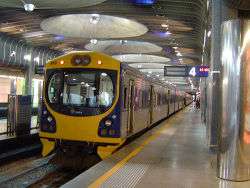
Rail services
Auckland has only one long distance rail passenger service: Northern Explorer (operated by Tranz Scenic, a division of KiwiRail) between Auckland and Wellington, operating on alternate days (ex Wednesday).
There are four main railway lines in the Auckland Region - the Western, Southern, Eastern and Onehunga lines. Urban rail services are operated under the AT brand by Transdev Auckland. Since the opening of Britomart Transport Centre, significant improvements were made to the local rail services. In October 2005, Sunday services were reintroduced for the first time in over 30 years, with more peak hour trains and later trains on Friday and Saturday nights in particular.
Recent (late 2000s and ongoing) investment in Auckland's rail services has resulted in strongly increased patronage, though from a very low level. Investment has focused on upgrading and refurbishing the current rolling stock and railway stations. Some double-tracking to allow higher frequencies has been undertaken or is in planning, and has resulted in a 25% increase in frequency, and a rise in punctuality (defined as trains being late 5 minutes or less) from 60.9% in 2005 to 83.1% in 2006.[24] Large new infrastructure investments have recently (mid 2007) been signed off by all parties, and NZ$1 billion will be invested within the next decade in electrifying the commuter network and buying new rolling stock to use on the electrified lines.[25] This is in addition to NZ$600 million already being spent on double-tracking heavily used sections of the network.[26] Major further works, such as a rail connection to Auckland Airport, a rail tunnel to North Shore City, or an underground loop tunnel through the Auckland CBD are proposed but have not yet moved beyond the concept stage.[27]
In November 2012 an engineering report said without the underground rail link, CBD traffic will slow to walking speed and the city's bus and train networks would be "significantly over capacity".[28]
Ferry services

A feature of Auckland transport is the popularity of commuting by ferry. A substantial minority of North Shore commuters avoid the Harbour Bridge congestion by catching ferries from Devonport, Stanley Bay, Bayswater or Birkenhead to the CBD. The ferries generally travel at least hourly, and in fact have longer hours of operation than many of Auckland's bus and railway lines.
Significant services also connect the city with Waiheke Island, Gulf Harbour and Half Moon Bay. Ferries to Great Barrier Island are less regular, with 4h-long passages once every 1–2 days, depending on the time of the year and the weather. Rangitoto, Motuihe Island and Tiritiri Matangi Island and the Coromandel have services usually focused on weekend and tourist trips.
Currently, there are no ferry services on the western shores of Auckland, and none are planned, as Auckland's waterfront orientation is much stronger towards the east (Waitemata Harbour) than to the west (Manukau Harbour).
Commercial shipping
Freight turnover
Auckland also has New Zealand's largest commercial port, its turnover exceeding even that of large rivals like Tauranga substantially. Ports of Auckland, the company managing all Auckland ports, handles the movement of 60% of New Zealand's imports and 40% of New Zealand's exports (both by value). 70% of this trade enters or leaves the country in containers - though ships unloading large amounts of cars are also a typical sight at the wharves of Auckland. The ports move 4 million tonnes of 'breakbulk' cargo per year, as well as over 670,000 TEUs (Twenty-foot equivalent container units) (2006).[29]
According to an economic impact assessment, a third of the regional economy and 173,000 jobs in Auckland Region are dependent on the port.[30]
Cruise ships
In the 2005/2006 season, POAL also catered for 48 cruise ship visits (at the Overseas Passenger Terminal, Princes Wharf), with more than 100,000 passengers passing through the port, mostly disembarking for short stopover trips into Auckland or the surrounding region.[31]
Air transport
With Auckland being the largest city of New Zealand, a great number of international and national flight connections exist. Main routes are to Australia, Singapore, Hong Kong, Japan, and to the US West Coast. Within New Zealand, the main connections are to the capital in Wellington and to the main city of the South Island, Christchurch. However, smaller planes fly to almost all other cities and to many small airports all over New Zealand.
Historically, Auckland had first been served by flying boat services from Mechanics Bay and Hobsonville. As aircraft such as the Short Solent and Short Sunderland were replaced by land-based planes, the first airport was opened at Mangere, supplanting earlier airfields at Ardmore and Whenuapai.

Airports
Auckland Airport, New Zealand's largest airport, lies beside Manukau Harbour, in the southern suburb of Mangere. It is a major base for Air New Zealand. A new runway is planned north of the main airport area, with a shorter length well suitable for the booming intra-New Zealand flight market.
Ongoing discussions concern the development of a second airport at Whenuapai, a RNZAF airbase in Waitakere, to the northwest of the Auckland conurbation. As the air force is signalled to move to Ohakea base near Palmerston North, the feasibility of a secondary airport north of the city is being explored.
Most private flights and light aircraft operate from the three smaller General Aviation (GA) airfields at the edges of the Auckland conurbation; Ardmore Airport south of the city which is NZ's busiest airfield in terms of movements, North Shore Aerodrome to the north and Parakai Airfield to the north west.
Mechanics Bay near the city centre, was the first international airport, and was used for many years as a base for flying boats of TEAL and amphibians of Tourist Air Travel and Sea Bee Air. The area now holds a heliport and the Auckland Marine Rescue Centre.
A Royal New Zealand Air Force facility at Hobsonville has been vacated and is currently under redevelopment primarily as a residential area, although some light commercial and industrial uses (for example super-yacht building) are present.
Walking and cycling
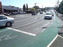
Auckland has a much less positive popular attitude towards cycling and new cycling infrastructure than cities like Wellington and Christchurch.[32] This, and to some degree the hillier nature of Auckland, have caused cycling to so far remain a marginal pursuit - only 1% of all morning peak trips are being made by bicycle.[33] In Wellington, with an even hillier topography, the cycling numbers were approximately twice as high as of 2008.[34] However, in the early 2010s, indications of a reversal appeared, with a regionwide gain in cycling numbers in 2010 by 27% over the year before, and an increase of 11% in the number of people who feel cycling is a safe way of travel in the region.[35]
Low numbers are reported for walking, with work commute trips in the Auckland Region having declined from 3.7% to 3.5% from 1996 to 2001, substantially below national levels of 5.4% in 2001. To compare with other urban areas, in Wellington more than twice (8.1%) of all trips to work were done by walking in 2001.[34] Similar to the situation for cycling, the walking environment in Auckland is considered badly degraded due to the car-centric design of most areas.[36]
Some efforts are being made to change this environment, with, for example, a number of shared space projects planned by Auckland City Council in several of the streets in the Auckland CBD, to improve the ability of pedestrians, cyclists and (slow-speed) motor vehicles to share the same transport spaces.[37]
See also
References
- ↑ Record number of roading projects on the go in Auckland in 2007/08 - Jackson, Bryan; Acting Chairman Transit New Zealand, article / public service announcement in The New Zealand Herald, Saturday 30 June 2007, Page C6
- 1 2 Backtracking Auckland: Bureaucratic rationality and public preferences in transport planning - Mees, Paul; Dodson, Jago; Urban Research Program Issues Paper 5, Griffith University, April 2006
- ↑ Mode of Transport, Figure for New Zealand Regions (from the Travel Survey Highlights 1997-98, New Zealand Ministry of Transport)
- ↑ Rudman, Brian (1 April 2011). "Standing room only as Aucklanders embrace a transport revolution". The New Zealand Herald. Retrieved 11 July 2011.
- 1 2 Savage, Jared (29 July 2007). "Welcome to our traffic nightmare". The New Zealand Herald. Retrieved 24 November 2011.
- ↑ Orsman, Bernard (24 October 2008). "Big steps to change City of Cars". The New Zealand Herald. Retrieved 24 November 2011.
- ↑ Mees, Paul; Dodson, Jago (1 February 2001). "The American Heresy: Half a century of transport planning in Auckland". Presentation to joint conference of New Zealand Geographical Society / Australian Institute of Geographers conference, University of Otago, Dunedin. Urban Planning Program, Faculty of Architecture, Building & Planning, University of Melbourne. Retrieved 9 February 2011.
- 1 2 History of Auckland City - Chapter 4 (from the Auckland City Council website. Accessed 2008-06-07.)
- 1 2 New Zealand Historical Atlas - McKinnon, Malcolm (Editor); David Bateman, 1997, Plate 75
- ↑ References provided in Public Transport in Auckland
- ↑ "Annual Auckland Scorecard 2012". Auckland Council, Mayoral Office - via New Zealand Herald. 6 November 2012.
- ↑ Williams, Andrew (8 May 2009). "Downsize this Super City madness". The New Zealand Herald. Retrieved 5 March 2010.
- ↑ Dearnaley, Mathew (20 March 2008). "Dearer petrol, but train payoff to come". The New Zealand Herald. Retrieved 5 March 2010.
- ↑ "Nth Shore Mayor thanks provinces for cash". The New Zealand Herald. 17 March 2009. Retrieved 5 March 2010.
- ↑ "Brian Rudman: Rest of NZ owes Auckland big time for roads". The New Zealand Herald. 18 March 2009. Retrieved 15 March 2010.
- ↑ Dearnaley, Mathew (10 June 2009). "New stations put extra pressure on ratepayers". The New Zealand Herald. Retrieved 15 March 2010.
- ↑ "Council to give up its rail stations". The New Zealand Herald. 21 March 2009. Retrieved 15 March 2010.
- ↑ Dearnaley, Mathew (25 November 2009). "$1b electric rail project gets go-ahead at last". The New Zealand Herald. Retrieved 15 March 2010.
- ↑ Dearnaley, Mathew (4 December 2006). "Motorway ramp lights turning on". The New Zealand Herald. Retrieved 24 November 2011.
- 1 2 Dearnaley, Mathew (8 March 2010). "Early start at Waterview". The New Zealand Herald. Retrieved 15 March 2010.
- ↑ Auckland-Manukau Eastern transport initiative (AMETI) (from the Auckland City Council website)
- ↑ Following the money - e.nz magazine, IPENZ January/February 2007
- 1 2 Dearnaley, Mathew (4 December 2006). "Spaghetti Junction comes to the boil". The New Zealand Herald. Retrieved 24 November 2011.
- ↑ Fewer fares but longer journeys - The New Zealand Herald, Wednesday, 11 October 2006, page A15.
- ↑ Dearnaley, Mathew (21 May 2007). "$1b Auckland rail upgrade powers ahead". The New Zealand Herald. Retrieved 22 September 2011.
- ↑ Rail Newsletter Issue 29 (published on the ARTA website, late 2006)
- ↑ References provided in Second Harbour Crossing, Auckland and Public Transport in Auckland
- ↑ "Rail tunnel Auckland's only option - report". 3 News NZ. 23 November 2012.
- ↑ Port Overview (from the Ports of Auckland homepage, 4 November 2006)
- ↑ "Michael Lee: Port creates a vital link in our economy". The New Zealand Herald. 15 February 2007. Retrieved 24 November 2011.
- ↑ Spectacular cruise ship season begins (from the Ports of Auckland website, 25 October 2006)
- ↑ On your bike - Auckland resistant to cycleways - LG - New Zealand Local Government, Volume 43 No 12, December 2007, Page 16.
- ↑ Shepheard, Nicola (24 February 2008). "Nicola Shepheard: Two-wheel zeal". The New Zealand Herald. Retrieved 24 November 2011.
- 1 2 Sustainable and safe land transport (from Statistics New Zealand. Accessed 2008-05-02.)
- ↑ "Dramatic increase in cyclist numbers in Auckland". Auckland Regional Transport Authority. 2 June 2010. Archived from the original on 2 June 2010. Retrieved 2 June 2010.
- ↑ "Take a hike, you pesky walkers". The New Zealand Herald. 27 November 2009. Retrieved 9 February 2011.
- ↑ Orsman, Bernard (19 January 2010). "$43.4m bill to mix cars and pedestrians". The New Zealand Herald. Retrieved 15 March 2010.
External links
- Fullers The Fullers Ferries company is the main provider for commuter services.
- SeaLink Formerly Subritzky, ferry service to Waiheke and Great Barrier.
- 360 Discovery Cruises Harbour Cruises and trips to Tiritiri Matangi Island, Motuihe and Coromandel
- Auckland Motorways (a private website covering the Auckland motorway system)