Trang, Thailand
| Trang ตรัง | |
|---|---|
| City Municipality | |
|
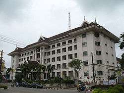
Trang City Hall | |
 Trang | |
| Coordinates: TH 7°33′27″N 99°36′37″E / 7.55750°N 99.61028°ECoordinates: TH 7°33′27″N 99°36′37″E / 7.55750°N 99.61028°E | |
| Country |
|
| Province | Trang Province |
| Amphoe | Mueang Trang District |
| Population (2005) | |
| • Total | 59,637 |
| Time zone | ICT (UTC+7) |
Trang (Thai: ตรัง, IPA: [traŋ], also Mueang Thap Thiang เมืองทับเที่ยง) is the capital of Trang Province, Thailand. The city (thesaban nakhon) has a population of 59,637 (2005) and covers the whole tambon Thap Thiang of Mueang Trang district. Trang is 839 km south of Bangkok.[1]
Geography
Trang lies on the Trang River, roughly halfway between the Tenasserim Hills and the coast of the Andaman Sea.[2]
Climate
Trang has a tropical monsoon climate (Köppen climate classification Am). At just 8°N, the temperature in Trang is sees little variation throughout the year, although the pre-monsoon months from February to April are a little hotter in the daytime. The year is divided into a short dry season, from January to March, and a long wet season from April to December, with the heaviest rain in September. There is still some rain, however, in the dry season.
| Climate data for Trang (1981–2010) | |||||||||||||
|---|---|---|---|---|---|---|---|---|---|---|---|---|---|
| Month | Jan | Feb | Mar | Apr | May | Jun | Jul | Aug | Sep | Oct | Nov | Dec | Year |
| Record high °C (°F) | 37.0 (98.6) |
40.0 (104) |
40.5 (104.9) |
40.3 (104.5) |
39.0 (102.2) |
36.8 (98.2) |
35.6 (96.1) |
35.7 (96.3) |
36.5 (97.7) |
35.6 (96.1) |
35.0 (95) |
34.8 (94.6) |
40.5 (104.9) |
| Average high °C (°F) | 32.6 (90.7) |
34.4 (93.9) |
35.3 (95.5) |
35.2 (95.4) |
33.6 (92.5) |
32.8 (91) |
32.3 (90.1) |
32.2 (90) |
31.9 (89.4) |
31.8 (89.2) |
31.3 (88.3) |
31.2 (88.2) |
32.9 (91.2) |
| Daily mean °C (°F) | 26.8 (80.2) |
27.6 (81.7) |
28.1 (82.6) |
28.3 (82.9) |
27.7 (81.9) |
27.4 (81.3) |
27.0 (80.6) |
27.0 (80.6) |
26.6 (79.9) |
26.4 (79.5) |
26.4 (79.5) |
26.2 (79.2) |
27.1 (80.8) |
| Average low °C (°F) | 21.9 (71.4) |
21.8 (71.2) |
22.5 (72.5) |
23.2 (73.8) |
23.4 (74.1) |
23.2 (73.8) |
22.9 (73.2) |
23.0 (73.4) |
22.9 (73.2) |
22.8 (73) |
22.7 (72.9) |
22.3 (72.1) |
22.7 (72.9) |
| Record low °C (°F) | 17.0 (62.6) |
15.0 (59) |
17.9 (64.2) |
18.7 (65.7) |
20.6 (69.1) |
20.2 (68.4) |
19.0 (66.2) |
19.5 (67.1) |
20.0 (68) |
20.2 (68.4) |
19.0 (66.2) |
17.5 (63.5) |
15.0 (59) |
| Average rainfall mm (inches) | 32.5 (1.28) |
20.8 (0.819) |
83.4 (3.283) |
139.7 (5.5) |
217.5 (8.563) |
201.1 (7.917) |
258.5 (10.177) |
275.1 (10.831) |
305.1 (12.012) |
285.5 (11.24) |
203.9 (8.028) |
125.4 (4.937) |
2,148.5 (84.587) |
| Average rainy days | 4.8 | 3.1 | 7.2 | 12.5 | 18.0 | 17.4 | 18.2 | 19.0 | 21.5 | 21.6 | 17.9 | 11.6 | 172.8 |
| Average relative humidity (%) | 75 | 72 | 74 | 79 | 84 | 85 | 86 | 85 | 87 | 88 | 86 | 81 | 82 |
| Mean monthly sunshine hours | 198.4 | 214.7 | 204.6 | 183.0 | 151.9 | 150.0 | 114.7 | 114.7 | 108.0 | 111.6 | 141.0 | 179.8 | 1,872.4 |
| Mean daily sunshine hours | 6.4 | 7.6 | 6.6 | 6.1 | 4.9 | 5.0 | 3.7 | 3.7 | 3.6 | 3.6 | 4.7 | 5.8 | 5.1 |
| Source #1: Thai Meteorological Department[3] | |||||||||||||
| Source #2: Office of Water Management and Hydrology, Royal Irrigation Department (sun and humidity)[4] | |||||||||||||
Transportation
The main road through Trang is Phetkasem Road (Route 4), which connects the city to Phatthalung and the border with Malaysia to the south-east, and to Krabi, Phang Nga, Phuket (via Route 402), Ranong, Chumphon, Prachuap Khiri Khan, Phetchaburi, Ratchaburi, and Bangkok to the north.
Trang is on a branch (terminating at Kantang of the Southern Line of the State Railway of Thailand.
Trang is served by Trang Airport, seven km from the city.[5] Thailand AirAsia and Nok Air provide service to Bangkok from Trang.
References
- ↑ "Distance: Bangkok to Trang". Google Maps. Retrieved 24 May 2015.
- ↑ "Trang". Tourism Authority of Thailand (TAT). Retrieved 24 May 2015.
- ↑ "Climatological Data for the Period 1981–2010". Thai Meteorological Department. p. 28–29. Retrieved 8 August 2016.
- ↑ "ปริมาณการใช้น้ำของพืชอ้างอิงโดยวิธีของ Penman Monteith (Reference Crop Evapotranspiration by Penman Monteith)" (PDF) (in Thai). Office of Water Management and Hydrology, Royal Irrigation Department. p. 120. Retrieved 8 August 2016.
- ↑ "Trang Airport". Department of Civil Aviation (DCA) Thailand: Trang. Retrieved 24 May 2015.
External links
 Trang travel guide from Wikivoyage
| Wikimedia Commons has media related to Trang (city). |
| ||