Bamberg
| Bamberg | ||
|---|---|---|
|
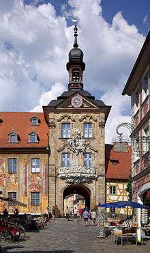
Old town hall (Altes Rathaus) in Bamberg | ||
| ||
 Bamberg | ||
| Coordinates: 49°54′N 10°54′E / 49.900°N 10.900°ECoordinates: 49°54′N 10°54′E / 49.900°N 10.900°E | ||
| Country | Germany | |
| State | Bavaria | |
| Admin. region | Upper Franconia | |
| District | Urban districts of Germany | |
| Government | ||
| • Lord Mayor | Andreas Starke (SPD) | |
| Area | ||
| • Total | 54.62 km2 (21.09 sq mi) | |
| Population (2015-12-31)[1] | ||
| • Total | 73,331 | |
| • Density | 1,300/km2 (3,500/sq mi) | |
| Time zone | CET/CEST (UTC+1/+2) | |
| Postal codes | 96047, 96049, 96050, 96051, 96052 | |
| Dialling codes | 0951 | |
| Vehicle registration | BA | |
| Website | ||
| Type | Cultural | |
| Criteria | ii, iv | |
| Designated | 1993 (17th session) | |
| Reference no. | 624 | |
| State Party | Germany | |
| Region | Europe and North America | |

Bamberg (German pronunciation: [ˈbambɛɐ̯k]) is a town in Upper Franconia, Germany, on the river Regnitz close to its confluence with the river Main. A large part of the town has been a UNESCO World Heritage Site since 1993.
History
![]() Prince-Bishopric of Bamberg 1245–1802
Prince-Bishopric of Bamberg 1245–1802
![]() Electorate of Bavaria 1802–1805
Electorate of Bavaria 1802–1805
![]() Kingdom of Bavaria 1806–1871
Kingdom of Bavaria 1806–1871
![]() German Empire 1871–1918
German Empire 1871–1918
![]() Weimar Republic 1918–1933
Weimar Republic 1918–1933
![]() Nazi Germany 1933–1945
Nazi Germany 1933–1945
![]() Allied-occupied Germany 1945–1949
Allied-occupied Germany 1945–1949
![]() West Germany 1949–1990
West Germany 1949–1990
![]() Germany 1990–present
Germany 1990–present
During the post-Roman centuries of Germanic migration and settlement, the region afterwards included in the Diocese of Bamberg was inhabited for the most part by Slavs. The town, first mentioned in 902, grew up by the castle Babenberch which gave its name to the Babenberg family. On their extinction it passed to the Saxon house.[2] The area was Christianized chiefly by the monks of the Benedictine Fulda Abbey, and the land was under the spiritual authority of the Diocese of Würzburg.
In 1007, Holy Roman Emperor Henry II or Heinrich II made Bamberg a family inheritance, the seat of a separate diocese. The emperor's purpose in this was to make the Diocese of Würzburg less unwieldy in size and to give Christianity a firmer footing in the districts of Franconia, east of Bamberg. In 1008, after long negotiations with the Bishops of Würzburg and Eichstätt, who were to cede portions of their dioceses, the boundaries of the new diocese were defined, and Pope John XVIII granted the papal confirmation in the same year. Henry II ordered the building of a new cathedral, which was consecrated 6 May 1012. The church was enriched with gifts from the pope, and Henry had it dedicated in honor of him. In 1017 Henry also founded Michaelsberg Abbey on the Michaelsberg ("Mount St. Michael"), near Bamberg, a Benedictine abbey for the training of the clergy. The emperor and his wife Kunigunde gave large temporal possessions to the new diocese, and it received many privileges out of which grew the secular power of the bishop. Pope Benedict VIII visited Bamberg in 1020[3] to meet Henry II for discussions concerning the Holy Roman Empire. While he was here he placed the diocese in direct dependence on the Holy See. He also personally consecrated some of Bamberg's churches. For a short time Bamberg was the centre of the Holy Roman Empire. Henry and Kunigunde were both buried in the cathedral.


From the middle of the 13th century onward the bishops were princes of the Empire[2] and ruled Bamberg, overseeing the construction of monumental buildings. In 1248 and 1260 the see obtained large portions of the estates of the Counts of Meran, partly through purchase and partly through the appropriation of extinguished fiefs. The old Bishopric of Bamberg was composed of an unbroken territory extending from Schlüsselfeld in a northeasterly direction to the Franconian Forest, and possessed in addition estates in the Duchies of Carinthia and Salzburg, in the Nordgau (the present Upper Palatinate), in Thuringia, and on the Danube. By the changes resulting from the Reformation, the territory of this see was reduced nearly one half in extent. Since 1279 the coat of arms of the city of Bamberg is known in form of a seal.
The witch trials of the 17th century claimed about one thousand victims in Bamberg, reaching a climax between 1626 and 1631, under the rule of Prince-Bishop Johann Georg II Fuchs von Dornheim.[4] The famous Drudenhaus (witch prison), built in 1627, is no longer standing today; however, detailed accounts of some cases, such as that of Johannes Junius, remain.[5]
In 1647, the University of Bamberg was founded as Academia Bambergensis.
Bambrzy (Posen Bambergers) are German Poles who are descended from settlers from the Bamberg area who settled in villages around Posen in the years 1719–1753.
In 1759, the possessions and jurisdictions of the diocese situated in Austria were sold to that state. When the secularization of church lands took place (1802) the diocese covered 3,305 km2 (1,276 sq mi) and had a population of 207,000. Bamberg thus lost its independence in 1802, becoming part of Bavaria in 1803.
Bamberg was first connected to the German rail system in 1844, which has been an important part of its infrastructure ever since. After a communist uprising took control over Bavaria in the years following World War I, the state government fled to Bamberg and stayed there for almost two years before the Bavarian capital of Munich was retaken by Freikorps units (see Bavarian Soviet Republic). The first republican constitution of Bavaria was passed in Bamberg, becoming known as the Bamberger Verfassung (Bamberg Constitution).
In February 1926 Bamberg served as the venue for the Bamberg Conference, convened by Adolf Hitler in his attempt to foster unity and to stifle dissent within the then-young Nazi party. Bamberg was chosen for its location in Upper Franconia, reasonably close to the residences of the members of the dissident northern Nazi faction but still within Bavaria.[6]
In 1973, the town celebrated the 1000th anniversary of its founding.
Historic population
| Year | Population |
|---|---|
| 1818 | 17,000 |
| 1885 | 31,521 |
| 1905 | 45,308 |
| Largest groups of foreign residents | |
| Nationality | Population (2013) |
| 1,076 | |
| 359 | |
| 232 | |
| 119 | |
| 115 | |
Geography
Bamberg is located in Franconia, 63 km (39 mi) north of Nuremberg by railway and 101 km (63 mi) east of Würzburg, also by rail. It is situated on the Regnitz river, 3 km (1.9 mi) before it flows into the Main river.
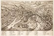
Its geography is shaped by the Regnitz and by the foothills of the Steigerwald, part of the German uplands. From northeast to southwest, the town is divided into first the Regnitz plain, then one large and several small islands formed by two arms of the Regnitz (Inselstadt), and finally the part of town on the hills, the "Hill Town" (Bergstadt).
The seven hills of Bamberg
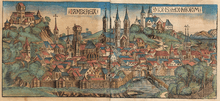
Bamberg extends over seven hills, each crowned by a beautiful church. This has led to Bamberg being called the "Franconian Rome" — although a running joke among Bamberg's tour guides is to refer to Rome instead as the "Italian Bamberg". The hills are Cathedral Hill, Michaelsberg, Kaulberg/Obere Pfarre, Stefansberg, Jakobsberg, Altenburger Hill and Abtsberg.
Climate
Climate in this area has mild differences between highs and lows, and there is adequate rainfall year round. The Köppen Climate Classification subtype for this climate is "Cfb" (Marine West Coast Climate/Oceanic climate).[7]
| Climate data for Bamberg (1981–2010) | |||||||||||||
|---|---|---|---|---|---|---|---|---|---|---|---|---|---|
| Month | Jan | Feb | Mar | Apr | May | Jun | Jul | Aug | Sep | Oct | Nov | Dec | Year |
| Average high °C (°F) | 2.9 (37.2) |
4.7 (40.5) |
9.5 (49.1) |
14.8 (58.6) |
19.7 (67.5) |
22.5 (72.5) |
24.9 (76.8) |
24.5 (76.1) |
19.8 (67.6) |
14.1 (57.4) |
7.3 (45.1) |
3.6 (38.5) |
14.03 (57.24) |
| Average low °C (°F) | −3.2 (26.2) |
−3.0 (26.6) |
0.2 (32.4) |
3.1 (37.6) |
7.6 (45.7) |
10.7 (51.3) |
12.7 (54.9) |
12.2 (54) |
8.6 (47.5) |
5.0 (41) |
1.2 (34.2) |
−1.8 (28.8) |
4.44 (40.02) |
| Average rainfall mm (inches) | 47.1 (1.854) |
39.0 (1.535) |
49.4 (1.945) |
41.5 (1.634) |
64.4 (2.535) |
61.4 (2.417) |
78.0 (3.071) |
55.3 (2.177) |
56.8 (2.236) |
51.1 (2.012) |
51.9 (2.043) |
55.0 (2.165) |
650.9 (25.624) |
| Mean monthly sunshine hours | 51.2 | 81.3 | 112.3 | 170.4 | 208.8 | 211.2 | 226.5 | 213.3 | 155.6 | 105.0 | 48.8 | 39.6 | 1,624 |
| Source: Météoclimat | |||||||||||||
Economy
In 2013 (latest data available) the GDP per inhabitant was €56,723. This places the district 10th out of 96 districts (rural and urban) in Bavaria(overall average: €39,691).[8]
Attractions

The old town of Bamberg is listed as a UNESCO World Heritage Site, primarily because of its authentic medieval appearance. The town established a documentation centre in 2005 to support World Heritage activities. Some of the main sights are:
- Bamberg Cathedral (1237), with the tombs of Emperor Henry II and Pope Clement II
- Alte Hofhaltung, residence of the bishops in the 16th and 17th centuries
- Neue Residenz, residence of the bishops after the 17th century
- Bamberg State Library in the New Residence
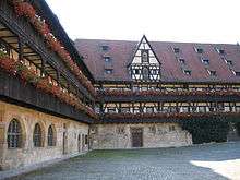
- Old town hall (1386), built in the middle of the Regnitz river, accessible by two bridges
- Klein-Venedig ("Little Venice"), a colony of fishermen's houses from the 19th century along one bank of the river Regnitz
- Michaelsberg Abbey, built in the 12th century on one of Bamberg's "Seven Hills"
- Altenburg, castle, former residence of the bishops
- Cathedral
Bamberg Cathedral is a late Romanesque building with four towers. It was founded in 1004 by Emperor Henry II, finished in 1012[2] and consecrated on 6 May 1012. It was later partially destroyed by fire in 1081. The new cathedral, built by Saint Otto of Bamberg, was consecrated in 1111 and in the 13th century received its present late-Romanesque form.
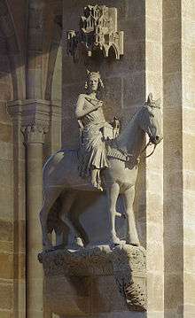
The cathedral is 94 m (308 ft) long, 28 m (92 ft) wide, 26 m (85 ft) high, and the four towers are each about 81 m (266 ft) high. It contains many historic works of art, such as the marble tomb of the founder and his wife, considered one of the greatest works of the sculptor Tilman Riemenschneider, and carved between 1499 and 1513. Another treasure of the cathedral is an equestrian statue known as the Bamberg Horseman (Der Bamberger Reiter).[2] This statue, possibly depicting the emperor Conrad III, most likely dates to the second quarter of the 13th century. The statue also serves as a symbol of the town of Bamberg.
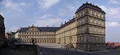
- Neue Residenz
The Neue Residenz (New Residence) (1698–1704) was initially occupied by the prince-bishops, and from 1864 to 1867 by the deposed King Otto of Greece. Its Rosengarten (Rose Garden) overlooks the town. It has over 4500 roses.[9]
- Altenburg

The Altenburg is located on the highest of Bamberg's seven hills. It was mentioned for the first time in 1109.[10] Between 1251 and 1553 it was the residence of Bamberg's bishops. Destroyed in 1553 by Albert Alcibiades, Margrave of Brandenburg-Kulmbach, it was used, after scanty repairs, only as a prison, and increasingly decayed.
In 1801, A. F. Marcus bought the castle and completely repaired it. His friend, the famous German writer E.T.A. Hoffmann, who was very impressed by the building, lived there for a while. The next owner, Anton von Greifenstein, in 1818 founded an association to save the castle. This society still maintains the whole property today. The Altenburg today houses a restaurant.
- Other sights
Other churches are the Jakobskirche, an 11th-century Romanesque basilica; the St. Martinskirche; the Marienkirche or Obere Pfarrkirche (1320–1387), which has now been restored to its original pure Gothic style. The Michaelskirche, 12th-century Romanesque (restored), on the Michaelsberg, was formerly the church of the Benedictine Michaelsberg Abbey secularized in 1803 and now contains the Bürgerspital, or almshouse, and the museum and municipal art collections.
Of the bridges connecting the sections of the lower town the Obere Brücke was completed in 1455. Halfway across this, on an island, is the Rathaus or town hall (rebuilt 1744-1756). The lyceum, formerly a Jesuit college, contains a natural history museum. The old palace (Alte Hofhaltung) was built in 1591 on the site of an old residence of the counts of Babenberg. Monuments include the Maximilian fountain (1880), with statues of King Maximilian I of Bavaria, the emperor Henry II and his wife, Conrad III and Saint Otto, bishop of Bamberg.[2]
There are also underground tunnels beneath the town. These were originally constructed as mines which supplied sandstone which could be used for construction or as an abrasive cleaner. Mining came to an end in 1920 but a 7.5-mile (12.1 km) tunnel network remained. The tunnels were used as an air raid shelter during World War II. A part of the network can be visited on a guided tour.[11]
Beer
Bamberg is known for its smoked Rauchbier and is home to nine breweries, Brauerei Fässla, Brauerei Greifenklau, Brauerei Heller-Trum (Schlenkerla), Brauerei Kaiserdom, Keesmann Bräu, Klosterbräu, Mahrs Bräu and Brauerei Spezial, and one brewpub, Ambräusianum. Every August there is a five-day Sandkerwa, a kirmess celebrated with beers.[12]
Education
The University of Bamberg, named Otto-Friedrich University, offers higher education in the areas of social science, business studies and the humanities, and is attended by more than 13,000 students. The University of Applied Sciences Bamberg offers higher education in the areas of public health. Bamberg is also home to eight secondary schools (gymnasiums):
- Clavius-Gymnasium
- Dientzenhofer-Gymnasium
- Eichendorff-Gymnasium
- E.T.A. Hoffmann-Gymnasium
- Franz-Ludwig-Gymnasium
- Kaiser-Heinrich-Gymnasium
- Maria-Ward-Gymnasium
- Theresianum
There are also numerous other institutes for primary, secondary, technical, vocational and adult education.
Infrastructure
Transport
Railway
The InterCityExpress main line #28 (Munich - Nuremberg - Leipzig - Berlin / Hamburg) runs through Bamberg station on the Nuremberg–Bamberg and the Bamberg–Hof lines. It takes less than two hours to Munich on the train and about four hours to reach Berlin. But the Nuremberg–Erfurt high-speed railway is currently being constructed through the Thuringian mountains and should shorten the journey time considerably.
East-west connections are poorer. Bamberg is connected to other towns in eastern Upper Franconia such as Bayreuth, Coburg, and Kronach via the Bamberg–Hof line with trains usually running at least every hour. Connections on the Würzburg–Bamberg line to the west are hourly regional trains to Würzburg, which is fully connected to the ICE network. Tourists arriving at Frankfurt International Airport need to change trains in Würzburg to connect to Bamberg or take a detour via Nuremberg.
Motorways
Bamberg is not near any of the major (i.e. single-digit) autobahns. But it is nevertheless well connected to the network in all directions: the A70 from Schweinfurt (connecting to the A7 there) to Bayreuth (connecting to the A9) runs along the northern edge of the town. The A73 on the eastern side of town connects Bamberg to Nuremberg (connecting to the A9) and Thuringia, ending at Suhl.
Air transport
Bamberg is served by Bamberg-Breitenau Airfield. Mostly public aircraft operate there. It used to be a military airport. (IATA-Code: ZCD, ICAO-Code: EDQA)
It is also possible to charter public flights to and from this airport.
Most international tourists who travel by plane arrive at Frankfurt International Airport or Munich Airport. The nearest major airport is Nuremberg Airport which can be reached within half an hour by car or one hour by train and subway.
Water transport
Both the Rhine-Main-Danube Canal and its predecessor, the Ludwig Canal, begin near Bamberg. The Ludwig Canal was opened in 1846 but closed in 1950 after damage during the second world war. With the completion of the Rhine-Main-Danube Canal in 1992, uninterrupted water transport was again made possible between the North Sea and the Black Sea.
Local public transport
Local public transport within Bamberg relies exclusively on buses. More than 20 routes connect the outlying quarters and some villages in the vicinity to the central bus station. In addition, there are several "Night Lines" (the last of these, though, tend to run around midnight) and some park-and-ride lines from parking lots on the periphery to the town centre.
A short-lived tram system existed in the 1920s.
Military bases
Bamberg was an important base for the Bavarian, German and then American military stationed at Warner Barracks. Warner Barracks was closed in fall 2014, with the last battalion leaving being the 54th Engineer Battalion. Discussions are ongoing on the future use of the barracks area, which has been returned to the German government.
Governance
Bamberg is an urban district, or kreisfreie Stadt. Its town council (Stadtrat) and its Mayor (Oberbürgermeister) are elected every six years, though not in the same year. Thus, the last municipal election for the town council was in 2014, for the Mayor in 2012. As an exception to the six-year term, the term starting in 2012 will take eight years to synchronize the elections with those in the rest of Bavaria.
As of the elections of 16 March 2014, the 44 member strong town council comprises comprises 12 CSU councillors, 10 SPD councillors, 8 Green councillors, 4 councillors of the Bamberger Bürger-Block and 4 of the Freie Wähler (Free Voters), both local political movements. These five parties achieved the number of councillors necessary to form a parliamentary group. In addition, there are 3 councillors of the Bamberger Unabhängige Bürger and the 1 councillor each of the Bamberger Realisten, the FDP and the Bamberger Linke Liste.
The previous council, elected on 2 March 2008, was composed of 15 CSU councillors, 10 SPD councillors, 7 Green councillors, 5 councillors of the Bamberger Bürger-Block and 3 of the Freie Wähler (Free Voters), both local political movements. These five parties achieved the number of councillors necessary to form a parliamentary group. In addition, there were 2 councillors of the Bamberger Realisten and one of the FDP and the Republikaner, making them ineligible for caucus status.
Mayors since 1945
| Years | Mayor | Party |
|---|---|---|
| 1945–1958 | Luitpold Weegmann | CSU |
| 1958–1982 | Theodor Mathieu | CSU |
| 1982–1994 | Paul Röhner | CSU |
| 1994–2006 | Herbert Lauer | Independent |
| 2006–Present | Andreas Starke | SPD |
Town twinning
Bamberg is twinned with:
-
 Bedford, United Kingdom
 -
 Esztergom, Hungary
 -
 Feldkirchen, Austria
 -
 Prague, Czech Republic
 -
 Rodez, France
 - Villach, Austria
-
 Fredonia, New York, United States
 -
 Nagaoka, Niigata, Japan
Notable people
.jpg)
A-K
- Annette von Aretin (1920–2006), first television announcer of the Bayerischer Rundfunk
- Carl Adam Bader, (1789 in Bamberg; † 1870 in Berlin), tenor
- Dorothee Bär (born 1978), Member of Parliament (CSU), State Secretary of the Federal Minister of Transport and Digital Infrastructure
- Wilhelm Batz, (1916–1988), Luftwaffe, ace
- Louis-Alexandre Berthier, (1753–1815), Chief of Staff to Napoleon Bonaparte
- Joachim Camerarius (1500–1574), humanist, polymath and poet
- Claudia Ciesla, (born 1987), Polish-German actress
- Pope Clement II, (died 1047), bishop of Bamberg from 1040–46
- Christopher Clavius, (1538–1612), mathematician, astronomer and Jesuit
- Conrad III of Germany, (1093-1152), king of Germany
- Cunigunde of Luxembourg, (c. 975-1040), empress consort, regent of the Holy Roman Empire and wife of Henry II
- Stefan Dassler (born 1962), non-fiction author
- Günther Denzler (born 1948), former district administrator of Bamberg (CSU)
- Karlheinz Deschner (1924–2014), writer and critic of religion and the church
- Gottfried Diener (1907–1987), philologist and Goethe researcher
- Ignaz Dollinger (1770–1841), physician
- Ignaz von Dollinger (1799–1890), important Catholic theologian and church historian
- Curt Echtermeyer, also known as Curt Bruckner (1896–1971), painter
- Erich Ebermayer (1900–1970), writer
- Hans Ehard (1887–1980), lawyer and politician
- Günter Faltin (born 1944), university teacher
- Heinrich Finck (1444–1527), conductor and composer
- Klaus-Dieter Fritsche (born 1953), jurist and politician (CSU),
- Karl von Gareis (1844–1923), a lawyer and author, member of the Reichstag
- Nora-Eugenie Gomringer, (born 1980), poet and writer
- Thomas Gottschalk (born 1950), moderator, tv-presenter, actor
- Lukas Görtler (born 1994), football player
- Hans Grassmann (born 1960), physicist and author
- Joseph Heller (1798–1849), collector, today Helleriana in Bamberg State Library
- Karl Höller (1907–1987), composer
- Georg Wilhelm Friedrich Hegel, (1770–1831), German philosopher
- Henry II, (973-1024), Holy Roman Emperor
- E. T. A. Hoffmann, (1776-1822), German author and composer
- Joachim Jung (born 1951), artist
- Harry Koch (born 1969), football player
- Lorenz Krapp (1882–1947), lawyer, poet and politician (BVP, CSU)
- Dieter Kunzelmann (born 1939), communard and left-wing activiste
- Paul Lautensack (1478–1558), painter and organist
L-Z
- Paul Maar, (born 1937), German writer and illustrator
- Duke Maximilian Joseph in Bavaria, actually Duke Maximilian Joseph in Bavaria (1808–1888), promoter of Bavarian folk music in the 19th century
- Emil Marschalk von Ostheim (1841–1903), historian and collector
- Duke Maximilian Joseph in Bavaria, actually Duke Maximilian Joseph in Bavaria (1808–1888), promoter of Bavarian folk music in the 19th centur
- Willy Messerschmitt (1898–1978), German aircraft designer, Flugzeugbau Messerschmitt GmbH
- Martin Münz (1785–1848), anatomist and professor
- Ida Noddack-Tacke, (1896-1978), chemist and physicist; she discovered element 75, rhenium
- Christopher Park (born 1987), pianist
- Bernd Redmann (born 1965), composer and musicologist
- Mike Rose, (1932-2006), painter, set designer and writer
- Gerd Schaller (born 1965), conductor
- Rainer Schaller (born 1969), entrepreneur and founder of McFit Fitness GmbH
- Claus Schenk Graf von Stauffenberg (1907–1944), German officer who attempted to assassinate German dictator Adolf Hitler in the July 20 Plot
- Berthold Maria Schenk Graf von Stauffenberg (born 1934), former General of the Bundeswehr
- Josh Shipp, (1986–Present), Professional basketball player for Brose Baskets Bamberg
- Tom Schütz (born 1988), football player
- Sven Schultze (born 1978), basketball player
- Karsten Tadda (born 1988), basketball player
- Andrew Wooten (born 1989), German-American soccer player
- Karl Friedrich Gottlob Wetzel, (1779-1819), writer and illustrator Fränkischer Merkur
Gallery
-

Old town hall
-

Old town hall with both bridges
-

Close-up of "Little Venice"
-

"Little Venice"
-

St Martin and Green Market
-
Neue Residenz (the "New Residence" of the prince-bishops)
-

The Rose Garden at the Neue Residenz
-

Rose Garden detail
-

Church of St Jacob
-

Bamberg roof tops from the Rose Garden
-

Music pavilion in park Hain, Bamberg
See also
References
- ↑ "Fortschreibung des Bevölkerungsstandes". Bayerisches Landesamt für Statistik und Datenverarbeitung (in German). June 2016.
- 1 2 3 4 5
 One or more of the preceding sentences incorporates text from a publication now in the public domain: Chisholm, Hugh, ed. (1911). "Bamberg". Encyclopædia Britannica. 3 (11th ed.). Cambridge University Press. pp. 301–302.
 - ↑ Dengler-Schreibe, Karin. Bamberg – For Newcomers and old friends. Reference to the visit to Bamberg by Pope Benedict VIII in 1020. Heinrichs-Verlag GmbH, Bamberg. p. 7. ISBN 9783898891066.
- ↑ "Im Bund mit dem Teufel".
Anfang des 17. Jahrhunderts wurden in Bamberg binnen 20 Jahren tausend Menschen verbrannt, weil sie angeblich einen Bund mit dem Teufel geschlossen hatten.
- ↑ "The Witch Persecution at Bamberg". Hanover College. Archived from the original on 19 August 2007. Retrieved 2007-08-26.
On Wednesday, June 28, 1628, was examined without torture Johannes Junius, Burgomaster at Bamberg, on the charge of witch-craft: how and in what fashion he had fallen into that vice. Is fifty-five years old, and was born at Niederwaysich in the Wetterau. Says he is wholly innocent, knows nothing of the crime has never in his life renounced God: says that he is wronged hefore God and the world, would like to hear of a single human being who has seen him at such gatherings [as the witch-sabbaths].
- ↑ See generally Kershaw, Ian (1999). Hitler 1889–1936: Hubris. New York: W. W. Norton & Company. pp. 274–78. ISBN 0-393-04671-0. See also Toland, John (1976). Adolf Hitler. New York: Doubleday & Company. pp. 213–18. ISBN 0-385-03724-4.
- ↑ Climate Summary for Bamberg
- ↑ "VGR der Länder, Kreisergebnisse für Deutschland - Bruttoinlandsprodukt, Bruttowertschöpfung in den kreisfreien Städten und Landkreisen der Bundesrepublik Deutschland 2000 bis 2013 (German)". Statistische Ämter der Länder und des Bundes. Retrieved 1 June 2016.
- ↑ "The World's 10 Most Beautiful Gardens Revealed". onlineread.org. Retrieved 30 November 2016.
- ↑ Archived April 11, 2013, at the Wayback Machine.
- ↑ https://web.archive.org/web/20150123065934/http://www.stripes.com/military-life/travel/bamberg-underground-tour-holds-deeper-understanding-of-city-s-history-1.63408
- ↑ Sandkerwa Bamberg (German)
- Herbermann, Charles, ed. (1913). "Bamberg". Catholic Encyclopedia. New York: Robert Appleton Company.
- JewishEncyclopedia
External links
| Wikivoyage has a travel guide for Bamberg. |
| Wikimedia Commons has media related to Bamberg. |
- Official municipal website
- Official tourist website
- Schlenkerla Brewery website
- Bamberg beer, official website