Towanda, Pennsylvania
| Towanda, Pennsylvania | |
|---|---|
| Borough | |
|
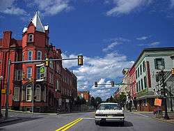
Main Street | |
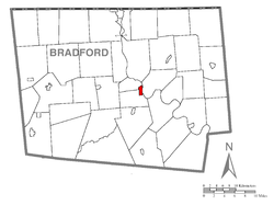 Map of Bradford County with Towanda highlighted | |
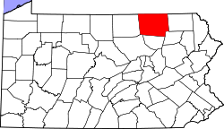
 Towanda Location of Towanda in the state of Pennsylvania | |
| Coordinates: 41°46′13″N 76°26′48″W / 41.77028°N 76.44667°WCoordinates: 41°46′13″N 76°26′48″W / 41.77028°N 76.44667°W | |
| Country | United States |
| State | Pennsylvania |
| County | Bradford |
| Settled | 1784 |
| Incorporated | 1828 |
| Government | |
| • Type | Council–manager |
| • Mayor | Garrett Miller |
| Area | |
| • Total | 1.17 sq mi (3.03 km2) |
| • Land | 1.14 sq mi (2.95 km2) |
| • Water | 0.03 sq mi (0.08 km2) |
| Elevation | 731 ft (223 m) |
| Population (2010) | |
| • Total | 2,919 |
| • Density | 2,564/sq mi (990.1/km2) |
| Time zone | Eastern (EST) (UTC-5) |
| • Summer (DST) | EDT (UTC-4) |
| Zip code | 18848 |
| Area code(s) | 570 |
| Website |
towandaborough |
Towanda is a borough and the county seat of Bradford County in the U.S. state of Pennsylvania.[1] It is located 66 miles (106 km) northwest of Wilkes-Barre, on the Susquehanna River. The name means "burial ground" in the Algonquian language.[2] Settled in 1784 and incorporated in 1828, Towanda was once known primarily for its industrial interests, which included flour, planing and silk mills, a foundry and machine shop, dye works, and manufacturers of talking machines, cut glass, toys and furniture. The population in 1900 was 4,663 and 4,281 in 1910. As of the 2010 census the population of Towanda was 2,919.[3]
History
The Towanda Historic District and Bradford County Courthouse are listed on the National Register of Historic Places.[4]
Geography
Towanda is located near the center of Bradford County at 41°46′13″N 76°26′48″W / 41.77028°N 76.44667°W (41.770251, −76.446545),[5] on the west bank of the Susquehanna River. It is bordered to the north and west by North Towanda Township, to the south and west by Towanda Township, and to the east, across the river, by Wysox Township.
U.S. Route 6 passes through the center of the borough, leading southeast 39 miles (63 km) to Tunkhannock and 60 miles (97 km) to the Scranton area, and west 37 miles (60 km) to Mansfield. U.S. Route 220 bypasses the borough to the west and leads north 18 miles (29 km) to its terminus at Waverly, New York and southwest 67 miles (108 km) to Williamsport.
According to the United States Census Bureau, the borough has a total area of 1.2 square miles (3.0 km2), of which 0.03 square miles (0.08 km2), or 2.55%, is water.[3]
Demographics
| Historical population | |||
|---|---|---|---|
| Census | Pop. | %± | |
| 1830 | 224 | — | |
| 1840 | 912 | 307.1% | |
| 1850 | 1,171 | 28.4% | |
| 1860 | 1,622 | 38.5% | |
| 1870 | 2,696 | 66.2% | |
| 1880 | 3,814 | 41.5% | |
| 1890 | 4,169 | 9.3% | |
| 1900 | 4,663 | 11.8% | |
| 1910 | 4,281 | −8.2% | |
| 1920 | 4,269 | −0.3% | |
| 1930 | 4,104 | −3.9% | |
| 1940 | 4,154 | 1.2% | |
| 1950 | 4,069 | −2.0% | |
| 1960 | 4,293 | 5.5% | |
| 1970 | 4,224 | −1.6% | |
| 1980 | 3,526 | −16.5% | |
| 1990 | 3,242 | −8.1% | |
| 2000 | 3,024 | −6.7% | |
| 2010 | 2,919 | −3.5% | |
| Est. 2015 | 2,812 | [6] | −3.7% |
| Sources:[7][8][9] | |||
As of the 2000 census,[8] there were 3,024 people, 1,279 households and 795 families residing in the borough. The population density was 2,674.2 per square mile (1,033.3/km²). There were 1,459 housing units at an average density of 1,290.2 per square mile (498.5/km²). The racial makeup of the borough was 96.36% White, 0.86% African American, 0.36% Native American, 1.19% Asian, 0.13% from other races, and 1.09% from two or more races. Hispanic or Latino of any race were 1.19% of the population.
There were 1,279 households of which 30.5% had children under the age of 18 living with them, 43.6% were married couples living together, 13.4% had a female householder with no husband present, and 37.8% were non-families. 31.7% of all households were made up of individuals and 12.7% had someone living alone who was 65 years of age or older. The average household size was 2.32 and the average family size was 2.92.
Age distribution was 25.1% under the age of 18, 7.7% from 18 to 24, 28.3% from 25 to 44, 22.4% from 45 to 64, and 16.6% who were 65 years of age or older. The median age was 38 years. For every 100 females there were 92.0 males. For every 100 females age 18 and over, there were 85.9 males.
The median household income was $35,814, and the median family income was $41,884. Males had a median income of $35,663 versus $23,796 for females. The per capita income for the borough was $17,438. About 9.9% of families and 13.4% of the population were below the poverty line, including 19.5% of those under age 18 and 4.0% of those age 65 or over.
Education
Towanda is home to the Lackawanna College Towanda Center which is a "premier, private, accredited two-year college serving the people of northeastern Pennsylvania" and satellite campus of Lackawanna College in Scranton, PA.
Government
Towanda has a council–manager form of government.
Notable people
- Nate Bump, relief pitcher for the Florida Marlins
- Edward T. Fairchild, Wisconsin jurist
- William W. Kingsbury,[10] United States House of Representatives, territorial delegate-Minnesota Territory
- Gregory La Cava, film director, perhaps best known for directing My Man Godfrey
- Kate Prusack
- Charles M. Webb, Wisconsin politician
- David Wilmot, politician
References
| Wikimedia Commons has media related to Towanda, Pennsylvania. |
- ↑ "Find a County". National Association of Counties. Retrieved 2011-06-07.
- ↑ http://www.epodunk.com/cgi-bin/genInfo.php?locIndex=14962
- 1 2 "Geographic Identifiers: 2010 Demographic Profile Data (G001): Towanda borough, Pennsylvania". U.S. Census Bureau, American Factfinder. Retrieved March 13, 2014.
- ↑ National Park Service (2010-07-09). "National Register Information System". National Register of Historic Places. National Park Service.
- ↑ "US Gazetteer files: 2010, 2000, and 1990". United States Census Bureau. 2011-02-12. Retrieved 2011-04-23.
- ↑ "Annual Estimates of the Resident Population for Incorporated Places: April 1, 2010 to July 1, 2015". Retrieved July 2, 2016.
- ↑ "Census of Population and Housing". U.S. Census Bureau. Retrieved 11 December 2013.
- 1 2 "American FactFinder". United States Census Bureau. Retrieved 2008-01-31.
- ↑ "Incorporated Places and Minor Civil Divisions Datasets: Subcounty Resident Population Estimates: April 1, 2010 to July 1, 2012". Population Estimates. U.S. Census Bureau. Retrieved 11 December 2013.
- ↑ Upham, Warren (1920). Minnesota Geographic Names: Their Origin and Historic Significance. Minnesota Historical Society. p. 493.
External links
- Borough of Towanda official website
- Towanda Online, local guide
- The Daily Review, local newspaper