Tortolita, Arizona
| Tortolita, Arizona | |
|---|---|
| CDP | |
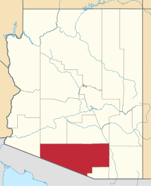
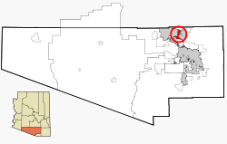 Location in Pima County and the state of Arizona | |
| Coordinates: 32°24′16″N 111°2′56″W / 32.40444°N 111.04889°WCoordinates: 32°24′16″N 111°2′56″W / 32.40444°N 111.04889°W | |
| Country | United States |
| State | Arizona |
| County | Pima |
| Area | |
| • Total | 11.9 sq mi (30.8 km2) |
| • Land | 11.86 sq mi (30.7 km2) |
| • Water | 0.04 sq mi (0.1 km2) |
| Elevation | 2,690 ft (820 m) |
| Population (2000) | |
| • Total | 3,740 |
| • Density | 314.3/sq mi (121.4/km2) |
| Time zone | MST (no DST) (UTC-7) |
| FIPS code | 04-74975 |
| GNIS feature ID | 1777314 |
Tortolita was a census-designated place (CDP) in Pima County, Arizona, United States. The population was 3,740 at the 2000 census. Tortolita was situated between the booming towns of Oro Valley and Marana. These two incorporated communities have annexed the community of Tortolita in the past. Eventually, it is speculated that the prior community known as Tortolita will become part of western Oro Valley and eastern Marana.
Geography
Tortolita was located at 32°24′16″N 111°2′56″W / 32.40444°N 111.04889°W (32.404322, -111.049006).[1] According to the 2000 census taken by the United States Census Bureau, the CDP had a total area of 11.9 square miles (31 km2), of which, 11.9 square miles (31 km2) of it was land and 0.04 square miles (0.10 km2) of it (0.34%) was water.
Census Tracts & Corresponding Census Designated Places
Tortolita was divided by Census tract. There were four census tracts which were designated as 46.31, 46.32, 46.33 and 46.34.[2] The census-designated place for these tracts has changed and as of the 2010 Census, they are now part of the CDP known as Casas Adobes, Arizona [3]
Demographics
As of the census[4] of 2000, there were 3,740 people, 1,332 households, and 1,057 families residing in the CDP. The population density was 314.9 people per square mile (121.6/km²). There were 1,408 housing units at an average density of 118.6/sq mi (45.8/km²). The racial makeup of the CDP was 92.51% White, 0.75% Black or African American, 0.80% Native American, 0.75% Asian, 2.65% from other races, and 2.54% from two or more races. 12.30% of the population were Hispanic or Latino of any race.
There were 1,332 households out of which 38.4% had children under the age of 18 living with them, 68.2% were married couples living together, 8.0% had a female householder with no husband present, and 20.6% were non-families. 15.4% of all households were made up of individuals and 4.0% had someone living alone who was 65 years of age or older. The average household size was 2.81 and the average family size was 3.15.
In the CDP the population was spread out with 27.6% under the age of 18, 6.9% from 18 to 24, 27.6% from 25 to 44, 29.7% from 45 to 64, and 8.3% who were 65 years of age or older. The median age was 39 years. For every 100 females there were 99.7 males. For every 100 females age 18 and over, there were 95.9 males.
The median income for a household in the CDP was $57,136, and the median income for a family was $64,573. Males had a median income of $44,886 versus $24,271 for females. The per capita income for the CDP was $25,550. About 5.7% of families and 5.2% of the population were below the poverty line, including 5.0% of those under age 18 and 7.8% of those age 65 or over.
References
- ↑ "US Gazetteer files: 2010, 2000, and 1990". United States Census Bureau. 2011-02-12. Retrieved 2011-04-23.
- ↑ "Tortolita Census Tract Map", Retrieved 2012-04-08.
- ↑ "Casas Adobes Census Tract Map", Retrieved 2012-05-29.
- ↑ "American FactFinder". United States Census Bureau. Retrieved 2008-01-31.