Tortola
 Tortola is the largest of the British Virgin Islands | |
 | |
| Geography | |
|---|---|
| Location | Atlantic Ocean |
| Coordinates | 18°25′24″N 64°37′05″W / 18.42333°N 64.61806°W |
| Archipelago | Virgin Islands |
| Area | 55.7 km2 (21.5 sq mi) |
| Length | 19 km (11.8 mi) |
| Width | 5 km (3.1 mi) |
| Highest elevation | 530 m (1,740 ft) |
| Highest point | Mount Sage |
| Administration | |
|
United Kingdom | |
| British Overseas Territory | British Virgin Islands |
| Largest settlement | Road Town (pop. 9,400) |
| Demographics | |
| Population | 23,908 |
| Pop. density | 429.23 /km2 (1,111.7 /sq mi) |
Tortola /tɔːrˈtoʊlə/ is the largest and most populated of the British Virgin Islands, a group of islands that form part of the archipelago of the Virgin Islands.[1] It has a surface area of 55 square kilometres (21 square miles) with a total population of 23,908, with 9400 residents in Road Town. Mount Sage is its highest point at 530 metres (1,740 feet) above sea level.
Etymology
Local tradition recounts that Christopher Columbus named the island Tórtola, meaning "turtle dove" in Spanish. In fact, Columbus named the island as Santa Ana. Dutch colonists called it Ter Tholen, after a coastal island that is part of the Netherlands. When the British took over, the name evolved to Tortola.
History
On his second voyage for the Spanish Crown to the Caribbean or West Indies, Christopher Columbus spotted what are now called the British and US Virgin Islands. He named the archipelago after the 11,000 virgins of the 5th-century Christian martyr St. Ursula. The Spanish made a few attempts to settle the islands, but pirates such as Blackbeard and Captain Kidd were the first permanent residents.
In the late 16th century, the English, who had successfully usurped control of the area from the Dutch, established a permanent plantation colony on Tortola and the surrounding islands. Settlers developed the islands for the sugarcane industry, with large plantations dependent on the slave labor of Africans transported across the Atlantic. The majority of early settlers came in the late eighteenth century: Loyalists from the Thirteen Colonies after the American Revolutionary War were given land grants here by the Crown to encourage development. They brought their slaves with them, who outnumbered the British colonists. The sugar industry dominated Tortola economic history for more than a century.
In the early 19th century, after Britain abolished the international slave trade, the Royal Navy patrolled the Caribbean to intercept illegal slave ships. The colony settled liberated Africans from these ships on Tortola, in the then-unsettled Kingstown area. St. Phillip's Church was built in the early 19th century in this community as one of the earliest free black churches in the Americas.
After the abolition of slavery in the British colonies in 1834, planters found it difficult to make a profit in the sugar industry based on paying and managing free labor. At this time, Cuba and some South American countries still had slave labor in the sugar industry. In addition, there were changes in the sugar industry, with sugar beets cultivated in England and the United States offering a competing product. During the downturn as sugar agriculture became less profitable, a large proportion of the white landowning population left the British Virgin Islands.
In the late 1970s, the British businessman Ken Bates attempted to lease a large part of the island on a 199-year lease, but this action was blocked. Noel Lloyd, a local activist, led a protest movement forcing the local government to drop the plan.[2] Today, a park on Tortola is named after Noel Lloyd and features a statue in his honour.[3]
Geography
Tortola is a mountainous island 19 km long and 5 km wide, with an area of 55.7 square km. Formed by volcanic activity, its highest peak is Mount Sage at 530 metres (1,740 feet). Tortola lies near an earthquake fault, and minor earthquakes are common.
Government
The House of Assembly in the BVI consists of 14 house representatives (The governor, 4 at-large, and 1 representative for each of the 9 districts). Cabinet consists of four. Whilst still under the English rule, the queen appoints a governor. The current governor is His Excellency John S. Duncan, who is the head of cabinet in the BVI. The House of Assembly is run by the Speaker of the House, Hon. Ingrid Moses Scatliffe. The deputy governor, is Mrs. Vivian Inez Archibald, the premiere is Dr. Hon. D. Orlando Smith, OBE. The National Democratic Party (NDP) has been in office for its second straight term now. (2011-present) The Virgin Islands Party (VIP) was in office for the four years before that. The party that rules over the house is determined by if that party has 7 or more seats in the house.
Economy and demographics
The population of Tortola is 23,908. The principal settlement is Road Town, the capital of the British Virgin Islands, with a population of 9400. Approximately 90 percent of the population identify as of African descent.
Provision of financial services is a major part of the economy. The International Business Companies Act, passed in the early 1980s, encouraged such businesses and has generated significant growth in professional jobs and related revenues. BVI residents are amongst the most affluent in the Eastern Caribbean. Numerous residents from other Caribbean islands also work here.
Although the British Virgin Islands (BVI) are under the British flag, it uses the U.S. dollar as its official currency due to its proximity to and frequent trade with the U.S. Virgin Islands and Puerto Rico. The island is home to many offshore companies that do business worldwide.
Attractions
The Northern coast has the best beaches on the island, including Smuggler's Cove, Long Bay, Cane Garden Bay, Brewer's Bay, Josiah's Bay, and Lambert beach. In addition to beaches, marine activities such as sailing, surfing, scuba diving, kite boarding, and windsurfing are available. Many tourists visit the historic sites and hike in parks. The island is visited regularly by large cruise ships.
Transportation
Tortola can be reached both by sea and by air. The island has taxi services.
Flights to Tortola arrive at the Terrance B. Lettsome International Airport. The airport is located on Beef Island, just to the East of Tortola, and is connected by the Queen Elizabeth II Bridge. Seaborne Airlines, Cape Air and Air Sunshine provide scheduled service from San Juan. Island Birds Air Charter connect to San Juan, St Thomas, Antigua or St Marten.
Many ferry companies provide travelers with the opportunity to arrive by sea. The ferries run between Charlotte Amalie in the center of St. Thomas, and Red Hook in the East End of St. Thomas and St. John, and either Road Town or the West End of Tortola.
Education
The British Virgin Islands operates several government schools.[4]
The following pre-primary schools serve Tortola residents:
- Althea Scatliffe Pre-Primary School
- Enid Scatliffe Pre-Primary School
The following elementary schools serve Tortola residents:[5]
- Century House Montessori School B.V.I
- Althea Scatliffe Primary School
- Seventh-day Adventist Primary School
- Enis Adams Primary School
- Joyce Samuel Primary School (formerly Belle Vue Primary School)
- Ivan Dawson Primary School
- Leonora Delville Primary School
- Francis Lettsome Primary School
- Alexandrina Maduro Primary School
- Isabella Morris Primary School
- Ebenezer Thomas Primary School
- Willard Wheatley Primary School
- St. Georges Primary School
- Cedar International School
- First Impressions School
- Pelican Gate School
- Agape Total Life Academy
The following High schools serve Tortola Residents:
- Elmore Stout High School (formerly British Virgin Islands High School)
- St George's Secondary School[6]
- Seventh-day Adventist Secondary School
- Cedar International School[7]
- Ansted College and approved Distance University Programs
Eslyn Henley Richiez Learning Centre serves as Tortola's special needs school.[8] The H. Lavity Stoutt Community College provides Tortola's Tertiary education
Sports
The city has been one of the Caribbean's prime basketball destinations as it hosted three of the last four Caribbean Basketball Championships.
Notable people
- J'maal Alexander, Olympic sprinter, was born in Tortola.
- Melanie Amaro, lived in Tortola with her grandmother as a child; she was the season 1 winner of the X Factor reality show.
- Isaac Glanville Fonseca, early political figure in the British Virgin Islands around the time of the restoration of democracy in 1950.
- George French (1817-1881), born and raised in Tortola, was the Chief Justice of Sierra Leone and the British Supreme Court for China and Japan
- Iyaz, international singing star, is from Carrot Bay, Tortola.
- Richard Humphreys (philanthropist)- Silversmith and Founder of Cheyney University, the first historically black institute of higher learning in the US.
Images
 Road Town
 Cane Garden Bay
 Lambert Beach
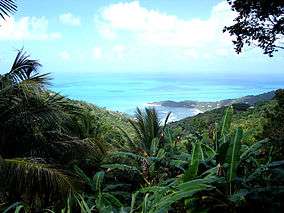 View of the North Coast
 Panoramic View of the Harbour at Road Town
 Panoramic View of Jost Van Dyke looking North West from above Smuggler's cove
See also
References
- ↑ "Tortola". British Virgin Islands. Retrieved 14 February 2013.
- ↑ Japhix (4 November 2011). "Noel Lloyd story published in UK magazine". BVI News.
- ↑ "The Noel Lloyd Positive Action Park". British Virgin Islands tourism.
- ↑ http://www.bvi.gov.vg/products.asp?iProd=35&iCat=12&hierarchy=0
- ↑ "The BVI Review".
- ↑ http://www.stgeorgesbvi.com
- ↑ http://www.cedarschoolbvi.com/
- ↑ http://bvibeacon.com/main/index.php?option=com_content&task=view&id=1070&Itemid=26
External links
| Wikivoyage has a travel guide for Tortola. |
![]() Media related to Tortola at Wikimedia Commons
Media related to Tortola at Wikimedia Commons
Coordinates: 18°25′24″N 64°37′05″W / 18.42333°N 64.61806°W