Torres del Paine National Park
| Torres del Paine National Park | |
|---|---|
|
IUCN category II (national park) | |
|
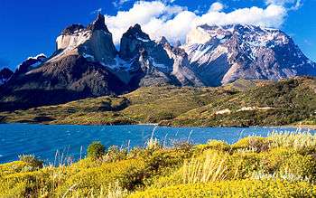
Cuernos del Paine from Lake Pehoe | |
 | |
| Location | Magallanes Region, Chile |
| Nearest city | Puerto Natales |
| Coordinates | 51°0′0″S 73°0′0″W / 51.00000°S 73.00000°WCoordinates: 51°0′0″S 73°0′0″W / 51.00000°S 73.00000°W |
| Area | 2,422.42 km2 (935 sq mi)[1] |
| Established | 1959 |
| Visitors | 143,253[2] (in 2012) |
| Governing body | Corporación Nacional Forestal |
Torres del Paine National Park (Spanish: Parque Nacional Torres del Paine)[3] is a national park encompassing mountains, glaciers, lakes, and rivers in southern Chilean Patagonia. The Cordillera del Paine is the centerpiece of the park. It lies in a transition area between the Magellanic subpolar forests and the Patagonian Steppes. The park is located 112 km (70 mi) north of Puerto Natales and 312 km (194 mi) north of Punta Arenas. The park borders Bernardo O'Higgins National Park to the west and the Los Glaciares National Park to the north in Argentine territory. Paine means "blue" in the native Tehuelche (Aonikenk) language and is pronounced PIE-nay.[4]
Torres del Paine National Park is part of the Sistema Nacional de Áreas Silvestres Protegidas del Estado de Chile (National System of Protected Forested Areas of Chile). In 2003, it measured approximately 242,242 hectares. It is one of the largest and most visited parks in Chile. The park averages around 150,000 visitors a year, of which 60% are foreign tourists,[5] who come from all over the world.
The park is one of the 11 protected areas of the Magallanes Region and Chilean Antarctica (together with four national parks, three national reserves, and three national monuments). Together, the protected forested areas comprise about 51% of the land of the region (6,728,744 hectares).
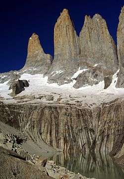
The Torres del Paine are the distinctive three granite peaks of the Paine mountain range or Paine Massif. They extend up to 2,500 meters above sea level, and are joined by the Cuernos del Paine. The area also boasts valleys, rivers such as the Paine, lakes, and glaciers. The well-known lakes include Grey, Pehoé, Nordenskiöld, and Sarmiento. The glaciers, including Grey, Pingo and Tyndall, belong to the Southern Patagonia Ice Field.
History
Lady Florence Dixie, in her book published in 1880, gave one of the first descriptions of the area and referred to the three towers as Cleopatra's Needles.[6] She and her party are sometimes credited as being the first "foreign tourists" to visit the area that is now called Torres del Paine National Park.[7]
Several European scientists and explorers visited the area in the following decades, including Otto Nordenskiöld, Carl Skottsberg, and Alberto María de Agostini.[7] Gunther Plüschow was the first person to fly over the Paine massif.
The park was established in 1959 as Parque Nacional de Turismo Lago Grey (Grey Lake National Tourism Park) and was given its present name in 1970.[7]
In 1976, British mountaineer John Gardner and two Torres del Paine rangers, Pepe Alarcon, and Oscar Guineo pioneered the Circuit trail which circles the Paine massif.[8]
In 1977, Guido Monzino donated 12,000 hectares (30,000 acres) to the Chilean Government when its definitive limits were established.[9] The park was designated a World Biosphere Reserve by UNESCO in 1978.[10]
Fires
In 1985, a tourist started a fire that burned about 150 km2 (58 sq mi) of the park. The blaze affected the areas east and south around Lake Pehoé.[1]
In February 2005, an accidental fire started by a Czech backpacker, which lasted for about ten days, destroyed 155 km2 (60 sq mi) of the park,[1] including about 2 km² of native forest. The Czech government offered aid after the fire and donated US$1 million to reforestation efforts.[11]
In late December 2011 through January 2012, a fire blamed on an Israeli backpacker[12] burned about 176 km2 (68 sq mi) of the reserve,[13] destroying about 36 km² of native forest[14] and affecting most of the areas around Lake Pehoé and the western areas around Lake Sarmiento, but moving away from the Cordillera del Paine, the park's centerpiece.[15] The Israeli government sent reforestation experts to the zone, and has committed to donate trees to replant the affected areas.[16]
Nevertheless, recent paleoenvironmental studies performed within the Park indicates that fire have been a frequent phenomena at least during the last 12,800 years.[17]
Climate

According to the Köppen climate classification, the park lies in the “temperate climate of cold rain without a dry season." The meteorological conditions of the park are variable due to the complex orography.
Temperatures
The zone is characterized by cool summers, with temperatures lower than 16 °C (61 °F) during the warmest month (January). Winter is relatively cold, with an average high temperature in July of 5 °C (41 °F), and an average low of −3 °C (27 °F).[18]
Precipitation
The rainiest months are March and April, with a monthly average rainfall of 80 mm. This represents double the July–October (winter) rainfall, which are the drier months. A study of the exact chemical components of the precipitation in the park has been carried out.[19]
Hydrology
The park possesses a large drainage network, which consists of numerous rivers, streams, lakes, ponds, and cascades that come from the Southern Patagonia Ice Field and flow towards the northeast until the Última Esperanza Sound that bathes the coasts of the city of Puerto Natales. The courses of water come from a longitudinal profile and are very turbulent with brusque changes in course, generated by waterfalls and rapids.
The Southern Patagonian Ice Field takes up the entire western side of the park. The Southern Patagonian Ice Field feeds four main glaciers; they are from north to south the glaciers: Dickson, Grey, Zapata, and Tyndall. This last glacier is rapidly receding. The largest is Glacier Grey. It is divided into two arms, because of the appearance of a peninsula of ice, commonly called the Island or Nunatak, that becomes apparent a little more with each year that passes. The eastern arm measures about 1.2 km while the western has a width around 3.6 km. The longitude of the glacier in its path towards the interior of the park is 15 km.
Studies of the glaciers in the park have given scientists a clearer picture of the epochs of the earth, or what happened after the last glacial age.[20][21][22]
In June 2014, scientists uncovered fossils of at least 46 ancient specimens of nearly complete skeletons of dolphin-like creatures called Ichthyosaurs which lived between 245 and 90 million years ago. The finding came after melting glaciers revealed new rock faces beneath.[23][24]
Geography

The landscape of the park is dominated by the Paine massif, which is an eastern spur of the Andes located on the east side of the Grey Glacier, rising dramatically above the Patagonian steppe. Small valleys separate the spectacular granite spires and mountains of the massif. These are: Valle del Francés (French Valley), Valle Bader, Valle Ascencio, and Valle del Silencio (Silence Valley).
The head of French Valley is a cirque formed by tall cliffs. The colossal walls of Cerro Cota 2000 and Cerro Catedral punctuate the western region of the Valley. Cerro Cota 2000 is named for its elevation; its highest contour line is about 2,000 m (6,562 ft). Cerro Catedral is named so because its east face resembles a cathedral's facade. To the north stands the granite arête called Aleta de Tiburón (English: Shark's Fin). To the east, from north to south, lie the peaks Fortaleza (Fortress), La Espada (The Sword), La Hoja (The Blade), La Máscara (The Mummer), Cuerno Norte (North Horn), and Cuerno Principal (Main Horn).
In the Valley of Silence the gigantic granite walls of Cerro Fortaleza and Cerro Escudo (Shield Mountain) stand face to face with the western faces of the Torres del Paine. Ascencio Valley is the normal route to reach the Torres del Paine lookout, which is located at the bank of a milky green tarn. The highest mountain of the group is Paine Grande, whose height was measured in 2011 using GPS and found to be 2,884 m (9,462 ft).
The Southern Patagonian Ice Field mantles a great portion of the park. Glaciers include the Dickson, the Grey, and the Tyndall.
Among the lakes are the Dickson Lake, Nordenskjöld Lake, Pehoe Lake, Grey Lake, Sarmiento Lake, and Del Toro Lake. Only a portion of the latter is within the borders of the park. All are vividly colored, most due to rock flour suspended in their waters. The main river flowing through the park is Paine River. Most of the rivers and lakes of the park drain into Última Esperanza Sound via Serrano River.

Geology
Much of the geology of the Paine Massif area consists of Cretaceous sedimentary rocks that have been intruded by a Miocene-aged laccolith.[25] Orogenic and erosional processes have shaped the present-day topography, and glacial erosion is mainly responsible for the sculpturing of the massif in the last tens of thousands of years. A good example of the latter is the Cuernos del Paine, whose central bands of exposed granite contrast strongly with the dark aspect of their tops, which are remnants of a heavily eroded sedimentary stratum.[26] In the case of Las Torres, what once was their overlying sedimentary rock layer has been completely eroded away, leaving behind the more resistant granite.
Biology

Flora
The last study of significant scope carried out concerning the flora of the park was realized by Pisano in 1974. This study examined four biotic zones that made up the territory of the park, determined by their vegetational type.
Torres del Paine National Park is adorned with beautiful vegetation, including the evergreen Embothrium coccineum, which produces vivid red flowers grouped in corymbs, and Calceolaria uniflora, of striking shape and colors.
The park has 7 documented species of Orchidaceae, including Chloraea magellanica.[27]
In the park 85 non-native plant species have been recorded, of which 75 are of European origin and 31 are considered to be invasive.[28]
The park contains four vegetation zones: Patagonian steppe, Pre-Andean shrubland, Magellanic subpolar forests and Andean Desert. The vegetation of the Patagonian steppe is dominated by Fescue species (mainly Festuca gracillima), which are resistant to harsh winds and weather conditions that are typical of the Patagonian region. Some of the dominant plant species of the Pre-Andean shrubland are Mulinum spinosum (a cushion plant) and Escallonia rubra, which are frequently associated with other species, including Anathrophyllun desideratum and Berberis buxifolia. The Magellanic deciduous forest is home to various species of trees such as the Nothofagus pumilio and Nothofagus antarctica. Above the tree line in the Andean Desert, Escallonia rubra, Empetrum rubrum, and Senecio skottsbergii take the place of Nothofagus pumilio trees.
A study on the beech trees and forest regeneration patterns in the park was published in 1992.[29]
Fauna
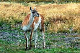
Guanacos are one of the most common mammals found in the park. Other mammals include foxes and pumas.[30] It is also home to the endangered Chilean Huemul. The puma's predation on guanacos in the park has been studied.[31]
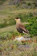
The park contains breeding populations of 15 bird of prey species and two others are likely reproducing here. Among them are Andean condor, black-chested buzzard-eagle, rufous-tailed hawk, cinereous harrier, chimango caracara, magellanic horned owl, austral pygmy-owl, to name but a few.[32] Other birds occurring in the park include the Chilean flamingo, Darwin's rhea, coscoroba swan, black-necked swan, Magellanic woodpecker, Magellan goose, and black-faced ibis.
- Fauna in Torres de Paine National Park


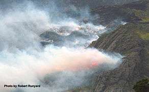 Wild fire at the Nordenskiöld Lake
Tourism
.jpg)
The national park has over 140,000 visitors per year.[2] It is a popular hiking destination in Chile. There are clearly marked paths and many refugios which provide shelter and basic services. Hikers can opt for a day trip to see the towers, walk the popular "W" route in about five days, or trek the full circle in 8 to 9 days. The refugio locations also have campsites. Cooking with the campstove is not permitted except in refugio locations. Camping is only allowed at specified campsites and wood fires are prohibited throughout the park. Fantastico Sur (private) and Vertice Patagonia (concessionaire) feature various refugios and campsites in the park. Since october 2016 it is mandatory to book campsites or refugios before entering the park. [33][34] For less adventurous visitors, there is a luxury hotel at the entrance to the park.[35]
Hikers are not allowed to stray from the paths in the national park. The visitor impact on the park has been scientifically measured.[36]
A certified guide is required to access some parts of the park. These arrangements need to be made before entering the park.
Visiting the park is recommended between September and April, during the southern spring, summer and early autumn. During summer daylight hours are very long given the extreme southern latitude. Outside of this time frame, the weather becomes extreme for the majority of the public. During the southern winter, daylight dwindles to only a few hours a day.
The park has been elected as the fifth most beautiful place in the world by National Geographic.[37][38]
Access routes
The park can be reached by Chile Route 9, which is paved and connects Punta Arenas and Puerto Natales and continues as an asphalt road for 100 km and then becomes a gravel road. In the winter using tyre chains is recommended due to unstable climatic conditions. The park can also be reached through maritime and aerial routes. There are buses that leave from Puerto Natales.[39]
See also
References
- 1 2 3 "Front page". El Mercurio. 2012-01-02.
- 1 2 National Forest Corporation: Estadística Visitantes 2012, 11 January 2013
- ↑ "Blown Away in Patagonia – Hiking Torres del Paine National Park". GORP.com. Retrieved 2012-01-02.
- ↑ Abraham, Rudolf (2011). Torres del Paine: Trekking in Chile's Premier National Park. Milnthorpe: Cicerone Press. p. 17. ISBN 978-1-84965-356-5. Retrieved 4 August 2015.
- ↑ Martínez, Rolando (03/07/2013). "Con casi 65 mil turistas, Parque Torres del Paine alcanza récord de visitas en el verano 2013" (in Spanish). Santiago de Chile: El Mercurio. Retrieved 25 April 2013. Check date values in:
|date=(help) - ↑ Dixie, Florence, Lady (1880). Across Patagonia. Available at the internet archive.
- 1 2 3 "History of the park". Official website. National Forest Service. Retrieved 2011-06-09.
- ↑ "Ice bold". The Sydney Morning Herald. 2008-11-13.
- ↑ "History of Estancia Torres del Paine". Fantastico Sur Lodges. Retrieved 2010-05-25.
- ↑ UNESCO - Park description at UNESCO World Biosphere Reserve
- ↑ "Chile and Czech Republic work to restore Torres del Paine Park — MercoPress". En.mercopress.com. Retrieved 2012-01-02.
- ↑ Magnezi, Aviel. "Israeli tourist: Wildfire in Chile not my fault". ynet.co.il. Retrieved 21 January 2014.
- ↑ Becerra, Alex; Diaz, Marcos; Zagal, Juan Cristobal. "Feasibility study of using a Small Satellite constellation to forecast, monitor and mitigate natural and man-made disasters in Chile and similar developing countries" (PDF). Retrieved 26 March 2013.
- ↑ "Cómo el fuego destruye esta reserva de la biósfera". El Mercurio. 2012-01-02.
- ↑ "Infografía: Áreas afectadas por el incendio en Torres del Paine". Emol.com. Retrieved 2012-01-02.
- ↑ "Israel presentará plan de reforestación en dos etapas para Torres del Paine". La Tercera. 2012-01-11. Retrieved 2012-01-11.
- ↑ Francois, J.P. "Historia paleoambiental del ecotono bosque-estepa al interior del Parque Nacional Torres del Paine (Región de Magallanes, Chile) durante los últimos 14.800 años". Thesis.
- ↑ "Ecocamp Patagonia". Retrieved 4 December 2012.
- ↑ Galloway, James N.; William C. Keene (March 20, 1996). "Processes controlling the composition of precipitation at a remote southern hemispheric location: Torres del Paine National Park, Chile". Journal of Geophysical Research. 101 (D3): 6883–6897. Bibcode:1996JGR...101.6883G. doi:10.1029/95jd03229. Retrieved 4 December 2012.
- ↑ Fogwill, C.J.; P.W. Kubik (22 July 2005). "A Glacial Stage Spanning the Antarctic Cold Reversal in Torres del Paine (51°S), Chile, Based on Preliminary Cosmogenic Exposure Ages". Geografiska Annaler: Series A, Physical Geography. A. 87 (2): 403–408. doi:10.1111/j.0435-3676.2005.00266.x. Retrieved 4 December 2012.
- ↑ Marden, Christopher J. (1997). "Late-glacial fluctuations of South Patagonian Icefield, Torres del Paine National Park, southern Chile". Quaternary International. 38-39: 61–68. doi:10.1016/S1040-6182(96)00019-5. Retrieved 4 December 2012.
- ↑ Rivera, Andrés; Gino Casassa (November 2004). "Ice Elevation, Areal, and Frontal Changes of Claciers from National Park Torres del Paine, Southern Patagonia Ice Field". Arctic, Antarctic, and Alpine Research. 36 (4): 379–389. doi:10.1657/1523-0430(2004)036[0379:IEAAFC]2.0.CO;2. Retrieved 4 December 2012.
- ↑ Dinosaur graveyard discovered in Chile's Torres del Paine National Park. 4 June 2014 – via YouTube.
- ↑ "Video: Dinosaur 'graveyard' discovered in Chile - Telegraph". Telegraph.co.uk. 4 June 2014.
- ↑ Uwe Altenberger; Roland Oberhansli; Benita Putlitz; et al. (July 2003). "Tectonic controls and Cenozoic magmatism at the Torres del Paine, southern Andes (Chile, 51°10'S)". Rev. Geol. Chile. [online]. 30 (1): 65–81. doi:10.4067/S0716-02082003000100005. Retrieved 2007-10-15.
- ↑ Michel, Jürgen; Lukas Baumgartner; Benita Putlitz; Urs Schaltegger; Maria Ovtcharova (2008). "Incremental growth of the Patagonian Torres del Paine laccolith over 90 k.y.". Geology. 36 (6): 459–462. doi:10.1130/g24546a.1. Retrieved 4 December 2012.
- ↑ Domínguez, Erwin (2004). "Catálogo preliminar de la familia Orchidaceae del Parque Nacional Torres del Paine, XII Región, Chile". Chloris Chilensis. 7 (1). Retrieved 2007-11-01.
- ↑ Domínguez, Erwin; Arve Elvebakk; Clodomiro Marticorena; Aníbal Pauchard (December 2006). "Plantas introducidas en el Parque Nacional Torres del Paine, Chile". Gayana Bot. [online]. 63 (2): 131–141. doi:10.4067/S0717-66432006000200001. Retrieved 2007-11-01.
- ↑ Armesto, J.J.; I. Casassa; O.Dollenz (1992). "Age structure and dynamics of Patagonian beech forests in Torres del Paine National Park, Chile". Vegetatio. 98: 13–22. doi:10.1007/bf00031633. Retrieved 4 December 2012.
- ↑ "A Wild But Fragile Chile: Torres del Paine National Park". Sounds and Colours. Retrieved 2011-08-23.
- ↑ Wilson, Paul (Oct 2009). "Puma predation on guanacos in Torres del Paine National Park, Chile". Mammalia. 48. doi:10.1515/mamm.1984.48.4.515.
- ↑ Jaksic, Fabián; Iriarte, J. Agustín; Jiménez, Jaime E. (June 2002). "Las rapaces del Parque Nacional Torres del Paine, Chile: biodiversidad y conservación". Rev. Chil. Hist. Nat. [online]. 75 (2): 449–461. doi:10.4067/S0716-078X2002000200014. Retrieved 2007-10-01.
- ↑ "Fantastico Sur". Retrieved 4 December 2012.
- ↑ "Vertice Patagonia". Retrieved 4 December 2012.
- ↑ "TorresdelPaine.com". Retrieved 4 December 2012.
- ↑ Farrell, Tracy A.; Jeffrey L. Marion (15 November 2010). "Trail Impacts and Trail Impact Management Related to Visitation at Torres del Paine National Park, Chile". Leisure. 26 (1-2): 31–59. doi:10.1080/14927713.2001.9649928. Retrieved 4 December 2012.
- ↑
- ↑ "National Geographic The World's Most Beautiful Places Special Issue". National Geographic. 2013. ASIN B00CUJ4K9Q. Retrieved 2 January 2016.
- ↑ "Interpatagonia". Retrieved 4 December 2012.
External links
| Wikimedia Commons has media related to Torres del Paine National Park. |
| Wikivoyage has a travel guide for Torres del Paine National Park. |
- Patagonia Webcam and maps from Paine and Puerto Natales
- TorresdelPaine.com
- Torres del Paine National Park – Patagonia in a New Light, travel article in The New York Times.