Toronto streetcar system
|
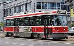
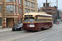
Toronto streetcar in May 2009. | |||
| Overview | |||
|---|---|---|---|
| Locale | Toronto, Ontario, Canada | ||
| Transit type | Streetcar | ||
| Number of lines | 11[1] | ||
| Number of stations | 685 stops,[2] including 8 shared with the subway (all others but one are street-level stops) | ||
| Daily ridership |
291,000 (avg. weekday, Q2 2014)[3] | ||
| Annual ridership | 100,037,500 (2013)[4] | ||
| Operation | |||
| Began operation | 1861 (electric lines since 1892)[1] | ||
| Operator(s) | Toronto Transit Commission | ||
| Character | Street running | ||
| Technical | |||
| System length | 83 km (52 mi)[5] | ||
| Track gauge | 4 ft 10 7⁄8 in (1,495 mm) Toronto gauge | ||
| Minimum radius of curvature | 36 ft 0 in (10,973 mm)[6] | ||
| Electrification | Overhead lines, 600 V DC | ||
| |||
The Toronto streetcar system is a network of eleven streetcar routes in Toronto, Ontario, Canada, operated by the Toronto Transit Commission (TTC). It is both the largest and busiest light-rail system in North America as well as the largest tramway in the Americas in terms of ridership, number of cars, and track length. The network is concentrated primarily in Downtown Toronto and in proximity to the city's waterfront. Much of the streetcar route network dates to the 19th century. Most of Toronto's streetcar routes operate on street trackage shared with vehicular traffic, and streetcars stop on demand at frequent stops like buses. Some routes operate wholly or partly within their own rights-of-way, and stop on demand at frequent stops.
There are underground connections between streetcars and the subway at St. Clair West, Spadina, and Union stations, and streetcars enter St. Clair, Dundas West, Bathurst, Broadview, and Main Street stations at street level. At the eight downtown stations, excepting Union, from Queen's Park to College on Line 1 Yonge–University, streetcars stop on the street outside the station entrances.
Toronto's streetcars provide most of the downtown core's surface transit service. Four of the TTC's five most heavily used surface routes are streetcar routes. In 2013, ridership on the streetcar system totalled more than 100 million.[4]
History
Early history (1861–1945)
In 1861, the City of Toronto (City) issued a thirty-year transit franchise (Resolution 14, By-law 353) for a horse-drawn street railway, after the Williams Omnibus Bus Line had become heavily loaded. Alexander Easton's Toronto Street Railway (TSR) opened the first street railway line in Canada on September 11, 1861, operating from Yorkville Town Hall to the St. Lawrence Market. At the end of the TSR franchise, the City government ran the railway for eight months, but ended up granting a new thirty-year franchise to the Toronto Railway Company (TRC) in 1891. The TRC was the first operator of horseless streetcars in Toronto. The first electric car ran on August 15, 1892, and the last horse car ran on August 31, 1894, to meet franchise requirements.
There came to be problems with interpretation of the franchise terms for the City. By 1912, the city limits had extended significantly, with the annexation of communities to the north (1912: North Toronto) and the east (1908: Town of East Toronto) and the west (1909: the City of West Toronto—The Junction). After many attempts to force the TRC to serve these areas, the City created its own street railway operation, the Toronto Civic Railways to do so, and built several routes. Repeated court battles forced the TRC to build new cars, but they were of old design. When the TRC franchise ended in 1921, the Toronto Transportation Commission (TTC) was created, combining the city-operated Toronto Civic Railways lines into its new network.
The TTC began in 1921 as solely a streetcar operation, with the bulk of the routes acquired from the private TRC and merged with the publicly operated Toronto Civic Railways.
In 1923, the TTC took over the Lambton, Davenport and Weston routes of the Toronto Suburban Railway (TSR) and integrated them into the streetcar system.
In 1925, routes were operated on behalf of the Township of York (as Township of York Railway), but the TTC was contracted to operate them. One of these routes was the former TSR Weston route.
In 1927, the TTC became the operator of three radial lines of the former Toronto and York Radial Railway. The TTC connected these lines to the streetcar system in order to share equipment and facilities, such as carhouses, but the radials had their own separate management within the TTC's Radial Department. The last TTC-operated radial (North Yonge Railways) closed in 1948.
Abandonment plans (1945–1989)
After the Second World War, many cities across North America and Europe[7] began to eliminate their streetcar systems in favour of buses. During the 1950s, the TTC continued to invest in streetcars and the TTC took advantage of other cities' streetcar removals by purchasing extra PCC cars from Cleveland, Birmingham, Kansas City, and Cincinnati.
In 1966, the TTC announced plans to eliminate all streetcar routes by 1980. Streetcars were considered out of date, and their elimination in almost all other cities made it hard to buy new vehicles and maintain the existing ones. Metro Toronto chair William Allen claimed in 1966 that "streetcars are as obsolete as the horse and buggy".[8] Many streetcars were removed from service when Line 2 Bloor–Danforth opened in February 1966.
The plan to abolish the streetcar system was strongly opposed by many in the city, and a group named "Streetcars for Toronto" was formed to work against the plan. The group was led by professor Andrew Biemiller and transit advocate Steve Munro. It had the support of city councillors William Kilbourn and Paul Pickett, and urban advocate Jane Jacobs. Streetcars for Toronto presented the TTC board with a report that found retaining the streetcar fleet would in the long run be cheaper than converting to buses. This combined with a strong public preference for streetcars over buses changed the decision of the TTC board.[9]
The TTC then maintained most of its existing network, purchasing new custom-designed Canadian Light Rail Vehicles (CLRV) and Articulated Light Rail Vehicles (ALRV). It also continued to rebuild and maintain the existing fleet of PCC (Presidents' Conference Committee) streetcars until they were no longer roadworthy.
The busiest north–south and east-west routes were replaced respectively by Yonge–University and Bloor–Danforth subway lines, and the northernmost streetcar lines, including the North Yonge and Oakwood routes, were replaced by trolley buses (and later by diesel buses).
Two other lines that operated north of St. Clair Avenue were abandoned for other reasons: the Rogers Road route was abandoned to free up streetcars for expanded service on other routes, and the Mount Pleasant route was removed because of complaints from drivers that streetcars slowed their cars down and because the track was aging and would have needed to be replaced.
Scarborough RT (1985–present)
Early proposals for Scarborough Rapid Transit (RT) line (now Line 3 Scarborough) were for operation with streetcars on a private right-of-way, but the plans were changed when the Ontario government persuaded the TTC and the borough of Scarborough to buy its Intermediate Capacity Transit System (ICTS) rapid transit trains instead. Another proposed streetcar/rapid transit line from Kipling station was abandoned, but the ghost platform at the bus level is a hint of a streetcar line.
Expansion period (1989–2000)
The TTC returned to building new streetcar routes in 1989. The first new line was route 604 Harbourfront, starting from Union Station, travelling underneath Bay Street and rising to a dedicated centre median on Queen's Quay (along the edge of Lake Ontario) to the foot of Spadina Avenue. This route was lengthened northward along Spadina Avenue in 1997, continuing to travel in a dedicated right-of-way in the centre of the street, and ending in an underground terminal at Spadina Station. At this time, the route was renamed 510 Spadina to fit with the numbering scheme of the other streetcar routes. This new streetcar service replaced the former route 77 Spadina bus, and since 1997 has provided the main north-south transit service through Toronto's Chinatown and the western boundary of University of Toronto's main campus. The tracks along Queen's Quay were extended to Bathurst Street in 2000 to connect to the existing Bathurst route, providing for a new 509 Harbourfront route from Union Station to the refurbished Exhibition Loop at the Exhibition grounds, where the Canadian National Exhibition is held.
21st century (2001–present)
.jpg)
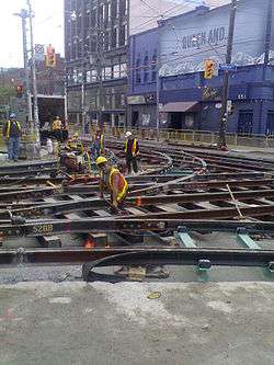
By 2003, two-thirds of the city's streetcar tracks were in poor condition as the older track was poorly built using unwelded rail attached to untreated wooden ties lying on loose gravel. The result was street trackage falling apart quickly requiring digging up everything after 10–15 years. Thus, the TTC started to rebuild tracks using a different technique. With the new technique, concrete is poured over compacted gravel, and the ties are placed in another bed of concrete, which is topped by more concrete to embed rail clips and rubber-encased rails. The resulting rail is more stable and quieter with less vibration. The new tracks are expected to last 25 years after which only the top concrete layer needs to be removed in order to replace worn rails.[10] [11]
Route 512 St. Clair was rebuilt to restore a separated right-of-way similar to that of the route 510 on Spadina Avenue, to increase service reliability and was completed on June 30, 2010.[12]
On December 19, 2010, 504 King streetcar service returned to Roncesvalles Avenue after the street was rebuilt to a new design which provided a widened sidewalk "bumpout" at each stop to allow riders to board a streetcar directly from the curb. When no streetcar is present, cyclists may ride over the bumpout as it is doubles as part of a bike lane.[13][14]
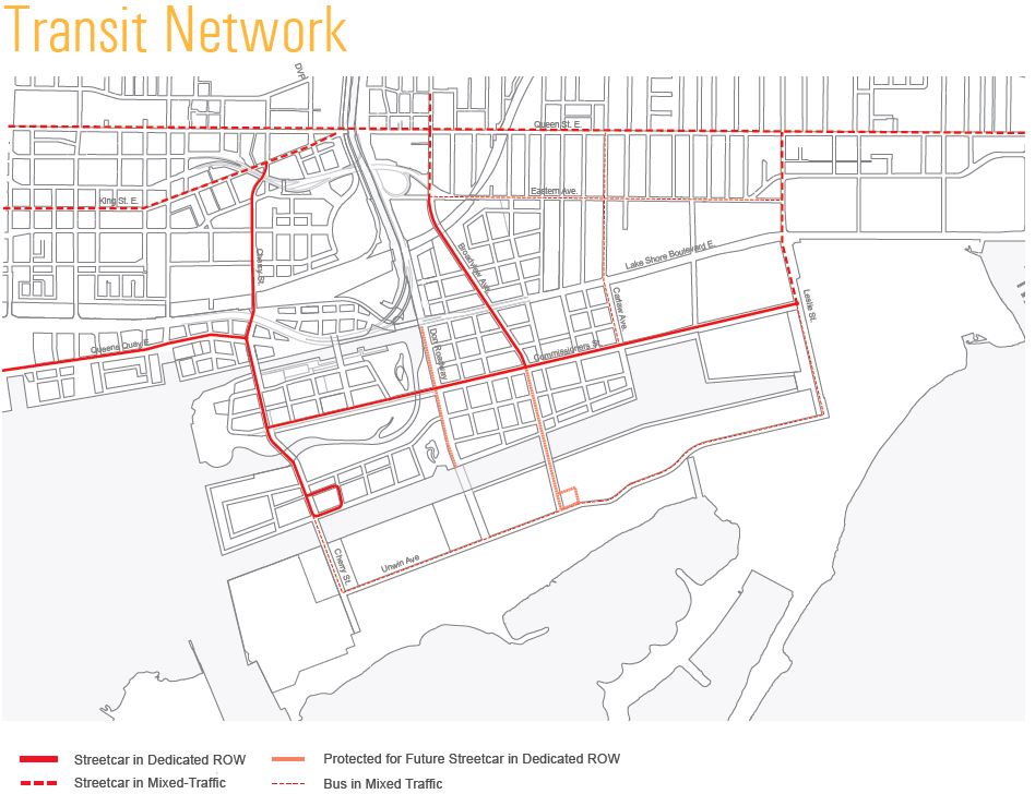
In April 2012, construction began on the 700-metre (2,300 ft) Cherry Street streetcar line (later designated as 514 Cherry), which will run in a dedicated right-of-way on Sumach and Cherry Streets from King Street to the railway corridor south of Mill Street, serving West Don Lands and the Distillery District.[15][16][17]
On October 12, 2014, streetcar service resumed on 509 Harbourfront route after the street was rebuilt to a new design that replaced the eastbound auto lanes with parkland from Spadina Avenue to York Street. Thus, streetcars since then run on a roadside right-of-way immediately adjacent to a park on its southern edge.[18]
The Toronto Transit Commission eliminated all Sunday stops on June 7, 2015, as these stops slowed down streetcars making it more difficult to meet scheduled stops. Sunday stops, which served Christian churches, were deemed unfair to non-Christian places of worship, which never had the equivalent of a Sunday stop. Toronto created Sunday stops in the 1920s along its streetcar routes to help worshippers get to church on Sunday.[19]
On November 22, 2015, the TTC started to operate its new fleet of Flexity streetcars from its new Leslie Barns maintenance and storage facility.[20]
On December 14, 2015, the TTC introduced Presto, proof-of-payment and all door loading for all streetcars on all routes. All streetcar passengers are required to carry proof that they have paid their fares such as a validated TTC ticket, paper transfer, pass or Presto card while riding.[21]
With the January 3, 2016 service changes, 510 Spadina became the first wheelchair-accessible streetcar route. All CLRV streetcars were expected to be withdrawn from the route, thus leaving only Flexity streetcars operating. However, CLRV and ALRV streetcars will be used as backup in the event of an insufficient availability of Flexity streetcars.[22]
On June 19, 2016 the TTC launched a new streetcar route operating along King Street between Dufferin and Sumach, dubbed the 514 Cherry. The route operates every 15 minutes or better, and will be partially operated with the commission's new accessible Flexity streetcars. [23]
Incidents
On December 16, 2010, the TTC suffered its worst accident since the Russell Hill subway crash in 1995. Up to 17 people, including four schoolchildren, were sent to hospital with serious but non-life-threatening injuries after a 505 Dundas streetcar heading eastbound collided with a Greyhound Canada bus at River Street.[24]
Routes
Based on 2013 statistics, the TTC operated 304.6 kilometres (189.3 mi)[2] of routes on 82 kilometres (51 mi) streetcar network (double or single track) throughout Toronto.[1][2] There are 11 regular streetcar routes, with the newest – 514 Cherry – launching on June 18, 2016:[25]
| Nº | Name | Full Length | Notes | Fleet |
|---|---|---|---|---|
| 501 | Queen | 24.43 km (15.18 mi) | Part of Blue Night Network as 301 Queen. | ALRV, CLRV |
| 502 | Downtowner | 9.38 km (5.83 mi) | Rush hour service only. | CLRV |
| 503 | Kingston Road | 8.97 km (5.57 mi) | Rush hour service only. | CLRV |
| 504 | King | 13.97 km (8.68 mi) | Part of the Blue Night Network service as 304 King since September 6, 2015.
Peak streetcar service in conjunction with bus service and ALRV. |
CLRV, ALRV |
| 505 | Dundas | 10.74 km (6.67 mi) | CLRV | |
| 506 | College/Carlton | 14.82 km (9.21 mi) | Part of Blue Night Network as 306 Carlton | CLRV |
| 509 | Harbourfront | 4.65 km (2.89 mi) | Route operates on a dedicated right-of-way. | CLRV, Flexity |
| 510 | Spadina | 6.17 km (3.83 mi) | Route operates on a dedicated right-of-way, part of the Blue Night Network service as 317 Spadina since September 6, 2015. | Flexity |
| 511 | Bathurst | 6.47 km (4.02 mi) | Seasonally uses ALRVs to handle Exhibition Place crowds, new Flexity low-floor streetcars were also used on this route during the 2015 Pan American Games and the 2015 Canadian National Exhibition. | CLRV, ALRV, Flexity |
| 512 | St. Clair | 7.01 km (4.36 mi) | Route reconstructed to a dedicated right-of-way (completed on June 30, 2010) | CLRV |
| 514 | Cherry | 7.01 km (4.36 mi) | From the Distillery Loop[26] to King, along King to Dufferin, south to the Dufferin-Exhibition Gate.[27] Launched June 18, 2016.[25] Since the roller destination signs for this route are not available on the older streetcars, they usually employ blank signs, although they sometimes bear "504 Dufferin" for cars heading westbound to the Dufferin-Exhibition Gate and/or "504 Parliament" for cars heading eastbound to the Distillery Loop. Because of this, the TTC introduced special dashboard signs (which are usually placed below the windshield on the "Short Turn" banner) to state the correct route information. |
CLRV, Flexity |
Route numbers
Until 1980, streetcar routes did not have numbers. When the CLRVs were introduced, the TTC assigned route numbers in the 500 series because the signs on the front of the new vehicles were not large enough to display both the route name and destination. Streetcar-replacement bus services also do not indicate the route name.
The four streetcar-operated Blue Night Network routes have been assigned 300-series route numbers. The other exception to the 500 series numbering was the Harbourfront LRT streetcar. When introduced in 1990, this route was numbered 604, which was intended to group it with the old numbering scheme for rapid transit routes. In 1996, the TTC overhauled its rapid transit route numbers and stopped trying to market the Harbourfront route as 'rapid transit'. The number was changed to 510. The tracks were later extended in two directions to form the 510 Spadina and 509 Harbourfront routes.[28]
During times when streetcar service on all or a portion of a route has been replaced temporarily by buses (e.g., for track reconstruction, major fire, special event), the replacement bus service is typically identified by the same route number as the corresponding streetcar line.
Dedicated rights-of-way
The majority of streetcar routes operate in mixed traffic, generally reflecting the original track configurations dating from the late 19th and early 20th centuries. However, newer trackage has largely been established within dedicated rights-of-way, in order to allow streetcars to operate with fewer disruptions due to delays caused by automobile traffic. Most of the system's dedicated rights-of-way operate within the median of existing streets, separated from general traffic by raised curbs and controlled by specialized traffic signals at intersections. Queen streetcars have operated on such a right-of-way along the Queensway between Humber and Sunnyside loops since 1957. Since the 1990s, dedicated rights-of-way have been opened downtown along Queens Quay, Spadina Avenue, St. Clair Avenue West, and Fleet Street.
Short sections of track also operate in tunnel (to connect with Spadina, Union, and St. Clair West subway stations). The most significant section of underground streetcar trackage is a tunnel underneath Bay Street connecting Queens Quay with Union Station; this section, which is approximately 700 m (2,300 ft) long, includes one intermediate underground station at Bay Street and Queens Quay.
During the late 2000s, the TTC reinstated a separated right-of-way — removed between 1928 and 1935[29] — on St. Clair Avenue, for the entire 512 St. Clair route. A court decision obtained by local merchants in October 2005 had brought construction to a halt and put the project in doubt; the judicial panel then recused themselves, and the delay for a new decision adversely affected the construction schedule. A new judicial panel decided in February 2006 in favour of the city, and construction resumed in summer 2006. One-third of the St. Clair right-of-way was completed by the end of 2006 and streetcars began using it on February 18, 2007. The portion finished was from St. Clair Station (Yonge Street) to Vaughan Road. The second phase started construction in the summer of 2007 from Dufferin Street to Caledonia Road. Service resumed using the second and third phases on December 20, 2009 extending streetcar service from St. Clair to Earlscourt Loop located just south and west of Lansdowne Avenue. The fourth and final phase from Earlscourt Loop to Gunns Loop (just west of Keele Street) is completed and full streetcar service over the entire route was finally restored on June 30, 2010.[30][31]
In 2008, the tracks on Fleet Street between Bathurst Street and the Exhibition Loop were converted to a dedicated right-of-way and opened for the 511 Bathurst and the 509 Harbourfront streetcars. Streetcar track and overhead power line were also installed at the Fleet loop, which is located at the Queen's Wharf Lighthouse.[32]
Future expansion
Transit City
The City of Toronto's and the TTC’s Transit City report[33] released on March 16, 2007, proposed creating new light rail lines. These are mainly separate from the streetcar network as the track gauge and vehicle specifications are quite different. Much of the original proposal has since been cancelled, and those that are proceeding are to be included in the subway part of the network.
Other proposals
The following are proposals to expand the streetcar system that were under consideration in 2015:
- The Waterfront West LRT would run from Long Branch Loop along Lake Shore Boulevard and the Queensway to King Street, and then adjacent to the Gardiner Expressway to Exhibition Loop and onto Union Station either via Queens Quay or Bremner Boulevard. This line originated from the Transit City proposals. It was shelved in 2013 but recommended for reconsideration in 2015 by city staff.[34]
- The East Bayfront LRT is planned to run along Queens Quay East from Union Station to complement the 509 Harbourfront line.[34]
- Waterfront Toronto is recommending the creation or extension of three streetcar lines in the Port Lands. Both the Cherry Street streetcar line and East Bayfront LRT would be extended to Queens Quay and Parliament Street. From there one line would run south on Cherry Street to the Ship Channel and another east along Commissioners Street to Leslie Street. Another line would be built along an extended Broadview Avenue south from Queen Street to Commissioners Street.[35]
Discontinued streetcar routes
Toronto Street Railway
Routes marked to City were operating on May 20, 1891, when the Toronto Street Railway Company's franchise expired and operations were taken over by the City of Toronto.[36]
| Route | Started | Ended | Notes |
|---|---|---|---|
| Bathurst | Sep 1889 | 7 Dec 1889 | to "Seaton Village" |
| Bloor | 29 May 1891 | -- | to City |
| Brockton | 4 Sep 1883 | May 1884 | from "Queen & Brockton"; to "Queen & Brockton" |
| Carlton & College | 2 Aug 1886 | -- | to City |
| Church | 18 Aug 1881 | -- | to City |
| Danforth | 8 Jul 1889 | -- | to City |
| Davenport | 18 Aug 1890 | -- | to City from "Seaton Village" |
| Dovercourt via McCaul | 24 Sep 1888 | -- | to City from "McCaul & College" |
| Front & McCaul | 22 Oct 1883 | 28 Jun 1884 | to "McCaul & College" |
| Front & Parliament | 25 Nov 1878 | 25 Jul 1881 | to "Parliament" and "Winchester" |
| High Park via Queen | Apr 1887 | to City | by this date; from "Queen & Parkdale" |
| King | 21 Sep 1874 | to City | longest continuously operated route in Toronto |
| King via Strachan | 2 Sep 1879 | 19 Sep 1890 | during Toronto Industrial Exhibition only; to "King" |
| Kingston Rd. | 9 Jun 1875 | Apr 1887 | Kingston Road Tramway Co.; by this date; part to "Woodbine" |
| Lee | 15 Jul 1889 | -- | to City |
| McCaul & College | 30 Jun 1884 | 22 Sep 1888 | from "Front & McCaul"; to "Dovercourt via McCaul" |
| McCaul & College | 15 Jul 1889 | -- | to City from "Dovercourt via McCaul" |
| Metropolitan | 26 Jan 1885 | -- | to City Metropolitan Street Railway |
| Parliament | 26 Jul 1881 | -- | to City from "Front & Parliament" |
| Queen | 2 Feb 1861 | 7 Dec 1881 | to "Queen & Brockton" |
| Queen | 4 Sep 1883 | May 1884 | from "Queen & Brockton"; to "Queen & Brockton" |
| Queen & Brockton | 8 Dec 1881 | 3 Sep 1883 | from "Queen"; to "Queen & Brockton" |
| Queen & Brockton | May 1884 | -- | to City from "Brockton" and "Queen" |
| Queen & Parkdale | 2 Sep 1879 | Apr 1887 | ended by spring 1887; to "High Park via Queen" |
| Queen East | 11 May 1885 | -- | to City from "Sherbourne" |
| Seaton Village | 27 Jul 1885 | -- | to City from "Spadina & Bathurst" |
| Sherbourne | 1 Dec 1874 | -- | to City may have begun a day or two earlier |
| Spadina | Jun 1879 | -- | to City |
| Spadina & Bathurst | 30 Jun 1884 | 25 Jul 1885 | from "Spadina"; to "Seaton Village" |
| Toronto Industrial Exhibition | 13 Sep 1883 | 19 Sep 1890 | first electric route; operated by steam during the 1891 season |
| Winchester | 26 Jul 1881 | -- | to City from "Front & Parliament" |
| Woodbine | 21 May 1887 | -- | to City from "Kingston Rd." |
| Yonge | 9 Nov 1861 | -- | to City first rail transit route in Toronto |
Toronto Railway Company
Routes marked to TTC were operating on September 21, 1921, when the Toronto Railway Company's operations were taken over by the Toronto Transportation Commission.[37]
| Route | Started | Ended | Notes |
|---|---|---|---|
| Arthur | 12 Feb 1902 | 1909 | merged with "Dundas" |
| Ashbridge | 5 Nov 1917 | to TTC | replaced by bus service in the 1920s.[38] |
| Avenue Road | 2 Sep 1895 | to TTC | |
| Bathurst | 27 Jul 1885 | to TTC | |
| Belt Line | 16 Nov 1891 | to TTC | |
| Bloor | 1889 | to TTC | |
| Broadview | Oct 1892 | to TTC | |
| Brockton | 1882 | 9 Oct 1893 | renamed "Dundas" |
| Carlton | Aug 1886 | to TTC | |
| Church | 1881 | to TTC | |
| College | Nov 1893 | to TTC | |
| Danforth | May 1889 | Oct 1892 | renamed "Broadview" |
| Davenport | Dec 1892 | Nov 1891 | replaced by "Bathurst", "Parliament" and "Winchester" |
| Dovercourt | Nov 1888 | to TTC | |
| Dufferin | 1889 | 30 Sep 1891 | merged with "Danforth" |
| Dundas | 9 Oct 1893 | to TTC | |
| Dupont | 29 Aug 1906 | to TTC | |
| Harbord | 29 Aug 1911 | to TTC | |
| High Park | 1886 | 1905 | |
| King | 1874 | to TTC | |
| Lee Avenue | 1889 | 15 May 1893 | merged into "King" |
| McCaul | Oct 1883 | 1 Jan 1896 | replaced by "Bloor" |
| Parkdale | 1880 | 1886 | renamed "High Park" |
| Parliament | 1881 | merged into "Queen" | |
| Queen | 2 Dec 1861 | to TTC | |
| Queen East | 1882 | 16 Oct 1891 | merged with "Danforth" |
| Roncesvalles | 1909 | 20 Dec 1911 | replaced by "Queen" |
| Seaton Village | 27 Jul 1885 | 23 Oct 1891 | replaced by "Davenport", "Parliament" and "Winchester" |
| Sherbourne | Nov 1874 | 16 Nov 1891 | merged into "Belt Line" |
| Spadina | 1878 | 16 Nov 1891 | merged into "Belt Line" |
| Winchester | Nov 1874 | to TTC | |
| Woodbine | May 1887 | 4 Apr 1893 | replaced by "King" |
| Yonge | 11 Sep 1861 | to TTC | |
| York | in operation in October 1891 and discontinued prior to 31 December 1891 | ||
Toronto Civic Railways
All routes transferred to the Toronto Transportation Commission.[39]
| Route | Started | Ended | Notes |
|---|---|---|---|
| Bloor | 4 Nov 1914 | to TTC | TCR and TRC Bloor routes merge into Broadview route and later replaced by Bloor–Danforth subway 1966 |
| Danforth | 30 Oct 1913 | to TTC | Same name, merged with Bloor route and finally replaced by Bloor–Danforth subway 1966 |
| Gerrard | 18 Dec 1912 | to TTC | Merger as Gerrard-Main route and later merged in Carlton route (now 506 Carlton) |
| Lansdowne | 16 Jan 1917 | to TTC | Two streetcar routes: Lansdowne (replaced by trolleybus route 1942) and Lansdowne North (replaced by Lansdowne North bus 1925); now part of 47 Lansdowne bus route |
| St. Clair | 25 Aug 1913 | to TTC | Same route as St. Clair route (now 512 St. Clair) |
Toronto Transportation Commission/Toronto Transit Commission
| Route | Began | Ended | Number | Notes |
|---|---|---|---|---|
| Belt Line | 1891 | 1923 | ||
| Bloor | 1890 | 1966 | ran MU cars 1950 to 1966 and then replaced by Line 2 Bloor–Danforth subway | |
| Coxwell | 1921 | 1966 | replaced by 22 Coxwell bus | |
| Dundas Exhibition | 1980 | 1986 | 522 | also operated during the 1995 season and the 2013 Canadian National Exhibition |
| Dupont/Bay | 1926 | 1963 | replaced by 6 Bay bus | |
| Earlscourt | 1954 | 1976 | merged into 512 St. Clair; assigned number 512L | |
| Fort | 1931 | 1966 | merged into 511 Bathurst | |
| Harbord | 1911 | 1966 | replaced by 72 Pape and 94 Wellesley buses | |
| Harbourfront | 1990 | 2000 | 604 | renumbered 509 Harbourfront |
| King Exhibition | 1980 | 2000 | 521 | temporarily reinstated in 2013, and operating as 521 Exhibition East |
| Lake Shore | 1995 | 2015 | 508 | cancelled due to streetcar shortage |
| Long Branch | 1928 | 1995 | 507 | merged in 501 Queen |
| Oakwood | 1922 | 1960 | replaced by 63 Ossington trolleycoach | |
| Parliament | 1910 | 1966 | replaced by 65 Parliament bus | |
| Spadina | 1923 | 1948 | replaced by the 77 Spadina bus; later replaced by the 510 Spadina streetcar in 1997 | |
| Winchester | 1910 | 1924 | replaced by Yonge and Parliament streetcars | |
| Mount Pleasant | 1975 | 1976 | split from 512 St. Clair; replaced by 74 Mt. Pleasant trolleycoach | |
| Rogers Road | 1922 | 1974 | replaced by 63F Ossington via Rogers trolleycoach | |
| Yonge | 1861 | 1954 | replaced by Yonge subway, Downtown bus, and Yonge trolleycoach |
Rolling stock
Hundreds of cars were acquired from the TTCs predecessor companies, including the Toronto Railway Company, Toronto Civic Railways, Toronto & York Radial Railway and Toronto Suburban Railway.
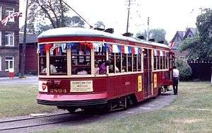
In the 1920s, the TTC purchased new Peter Witt streetcars, and they remained in use into the 1960s. In 1938 the TTC started to operate its first Presidents' Conference Cars (PCC), eventually operating more than any other city in North America. The last of these vehicles was retired from full-time revenue service in the 1990s, after new Canadian Light Rail Vehicles entered service.
On August 31, 2014, the TTC started operating its first Bombardier Flexity Outlook vehicles. Older vehicles will be retired when enough new vehicles are in service.
Streetcars purchased by the TTC
Note that not all numbers within a series were used.
| Fleet numbers | Type | In service | Notes |
|---|---|---|---|
| 2300–2678 2900–3018 | Peter Witt | 1921–1954 | "large" Witts; even numbers only |
| 2700–2898 | Peter Witt | 1922–1965 | "small" Witts; even numbers only |
| 2301–2419 | 2-door trailer | 1921–1938 | odd numbers only |
| 2701-3029 | 3-door trailer | 1923–1954 | "Harvey" trailers; odd numbers only |
| 4000–4299 4575–4601 | PCC | 1938–1971 | air-electric |
| 4300–4574 4625–4779 | PCC | 1947–1995 | all-electric, PCC 4500 and 4549 restored and still maintained[40] |
| 4000–4199 | CLRV | 1977–current | will be phased out as Flexity Outlooks start entering service in 2014 |
| 4200–4251 | ALRV | 1987–current | articulated; will be phased out when Flexity Outlook (Toronto LRT car) start entering service in 2014 |
| 4900 | ALRV | 1982–1983 | prototype; never owned by TTC but by UTDC; used on TTC test runs and returned (later scrapped); painted with similar TTC scheme |
| 4400–4603 | Flexity | 2014–current | 2013, testing; 2014, revenue service |
Winter operational issues
The fleet of CLRV and ALRV has experienced operational issues during extreme cold temperatures in early 2015 as doors and brakes fail as moisture in the pneumatic lines freezes.[41] As a result, the TTC will often substitute buses during extreme cold conditions to prevent cars from blocking roads or getting into accidents when brakes fail to deploy. The problem is being resolved with the new Flexity cars which use electronic braking and door operations.[41]
Track gauge
The tracks of Toronto's streetcars and subways are built to the unique track gauge of 4 ft 10 7⁄8 in (1,495 mm), 2 3⁄8 in (60 mm) wider than the usual 4 ft 8 1⁄2 in (1,435 mm) standard gauge, which Line 3 Scarborough uses.[42] According to Steve Munro, an expert on the history of Toronto area transit, TTC gauge is "English carriage gauge".
That the gauge of the said railways shall be such that the ordinary vehicles now in use may travel on the said tracks, and that it shall and may be lawful to and for all and every person and persons whatsoever to travel upon and use the said tracks with their vehicles loaded or empty, when and so often as they may please, provided they do not impede or interfere with the cars of the party of the second part (Toronto Street Railway), running thereon, and subject at all times to the right of the said party of the second part, his executors, and administrators and assigns to keep the said tracks with his and their cars, when meeting or overtaking any other vehicle thereon.[43]
As wagons were normally built at standard gauge, the streetcar rails were selected to be slightly wider, allowing the wagons to ride on the inside sections of the rail, and the streetcars on the outside. The Williams Omnibus Bus Line changed the gauge of their buses in 1861 to fit this gauge. At the time, track for horsecars was not our modern 'T' rail, but wide and flat, with a raised section on the outside of the rail.
According to the TTC, the City of Toronto feared that the street railway franchise operator, first in 1861, the Toronto Street Railway, then in 1891, the Toronto Railway Company, and in 1921, the TTC, would allow the operation of steam locomotives and freight trains through city streets, as was common practice in Hamilton, Ontario (until the 1950s) and in many US cities, such as New York City and Syracuse, New York.[42]
Standard gauge rails in the streets would have allowed this, but steam railway equipment could not follow the abrupt curves in the streetcar network. Opposition to freight operation in city streets precluded interchange even with adjacent radial lines even after the lines changed to TTC gauge. Electric railway freight cars could negotiate street curves, but freight operations to downtown were still not allowed until the final few years of radial operation by the TTC.
The unique gauge has remained to this day since converting all tracks and vehicles would be expensive and would lack any real benefit anyway. Some proposals for the city's subway system involved using streetcars in the tunnels, possibly having some routes run partially in tunnels and partially on city streets, so the same gauge was used, but the idea was ultimately dropped in the case of dedicated rapid-transit trains.
Besides the Toronto streetcar and subway systems, the Halton County Radial Railway uses the Toronto gauge of 4 ft 10 7⁄8 in (1,495 mm) for its museum streetcar line.
Pre-TTC
Before TTC ownership, however, the streetcar gauge was either 4 ft 10 3⁄4 in (1,492 mm) or 4 ft 11 in (1,499 mm) depending on historical source instead of today's 4 ft 10 7⁄8 in (1,495 mm).
According to Raymond L. Kennedy said: "The street railways were built to the horse car gauge of 4 feet 10 and 3/4 inches. (The TTC changed this to 4 10 7/8 and is still in use today even on the subway.)"[44] James V. Salmon said the "city gauge" was 4 ft 10 3⁄4 in.[45] Both these sources were describing a former streetcar junction at the intersection of Dundas and Keele Streets laid entirely to Toronto streetcar gauge until August, 1912. The junction was used by both the Toronto Suburban Railway and the Toronto Railway Company.
However, Ken Heard, Consultant Museologist, Canadian Museums Association, was reported to say: "One of the terms of these agreements was that the track gauge was to accommodate wagons. As horse car rail was step rail, the horse cars, equipped with iron wheels with flanges on the inside, ran on the outer, or upper step of the rail. Wagon wheels naturally did not have a flange. They were made of wood, with an iron tire. Wagons would use the inner, or lower step of the rail. The upper step of the rail guided the wagons on the track. In order to accommodate this arrangement, the track gauge had to be 4 feet, 11 inches. As the streets themselves were not paved, this arrangement permitted wagons carrying heavy loads a stable roadbed."[43] In support of Heard's statement about the pre-TTC gauge, the Charter of the Toronto Railway Company said "the gauge of system (4 ft. 11 in.) is to be maintained on main lines and extensions thereof".[46]
Properties
Dedicated station
Queens Quay is the one standalone underground station that does not connect to the subway. It is located in the tunnel, shared by the 509 Harbourfront and 510 Spadina routes, between Queens Quay West and Union subway station.
Loops
Since all of Toronto's current streetcars are single-ended, turning loops are provided at the normal endpoints of each route and at likely intermediate turnback locations. A routing on-street around one or more city blocks may serve as a loop, but most loops on the system are wholly or partly off-street. Many of these are also interchange points with subway or bus services.
Carhouses
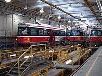
Toronto's streetcars are housed and maintained at various carhouses or "streetcar barns":
| Yard | Location | Year Open | Notes |
| Hillcrest Complex | Davenport Road and Bathurst Street | 1924 | Newly built by TTC on former site of farm and later Toronto Driving Club track; services streetcars and buses, repair facilities |
| Roncesvalles Carhouse | Queen Street West and Roncesvalles Avenue | 1895 (for TRC); rebuilt 1921 (by TTC) | Property acquired Toronto Railway Company, but new carbarn built in 1921 with indoor inspection and repair facility and outdoor streetcar storage tracks |
| Russell (Connaught Avenue) Carhouse | Connaught Avenue and Queen Street East | 1913 (by TRC and 1916 carhouse added); 1924 (rebuilt by TTC) | Built for the Toronto Railway Company as paint shop and 1916 carhouse built to replace King carhouse lost to a fire in 1916; acquired by the TTC in 1921 and rebuilt in 1924 with indoor maintenance facility and outdoor streetcar storage tracks |
| Leslie Barns | Leslie Street and Lake Shore Boulevard East - southeast corner | November 2015 | Carhouse opened November 2015 and receiving some of Flexity fleet (100 of the 204 cars)[47] It will be fully opened by early 2016. |
Inactive carhouses once part of the TTC's streetcar operations:
| Yard | Location | Year Open | Year Closed | Notes |
| Danforth Carhouse | Danforth Avenue and Coxwell Avenue | 1915; 1921-22 (additions by TTC) | 2002 | built for the Toronto Civic Railways in 1915 and additional indoor storage added by TTC in 1921-22; re-purposed as bus garage in 1967; closed in 1921 but still used by TTC for storage and office space |
| Dundas Carhouse | Dundas Street West and Howard Park Avenue | 1907 | 1936 | Original acquired from TRC (built in 1907), but carhouse was demolished in 1921 but retained for storage for 60 cars; wye and runaround loop since disappeared and area re-developed with cars moving to Roncesvalles |
| Eglinton (Yonge) Carhouse | Eglinton Avenue West and Yonge Street | 1922 | 2002; demolished | Built to replace TRC Yorkville Carhouse and retired as carhouse in 1948 to become bus garage until 2002; most of facility now demolished and remainder used as temporary bus terminal |
| Harbour Yard | Lakeshore Boulevard between Bay and York Streets | 1951 | 1954 | Built as temporary outdoor storage space for Peter Witt cars after Eglinton Carhouse closed to streetcars; tracks removed 1954; now site of parking lot and office towers |
| Lansdowne Carhouse | Lansdowne Avenue and Paton Avenue | 1911 | 1996; demolished 2003 | Built for the Toronto Railway Company and acquired by TTC in 1921; became a trolley bus garage in 1947 and streetcar storage ended 1967; abandoned after 1996 and demolished 2003 |
| St. Clair (Wychwood) Carhouse | Wychwood south of St. Clair Avenue West | 1914 | 1978 | Built for the Toronto Civic Railways in 1914 and expanded 1916. Acquired by TTC in 1921 with renovations and renamed as Wychwood Barns; closed in 1978 after cars moved to Roncesvalles but continued to be used for storage until the 1990s; tracks removed and restored as community centre. |
| Yorkville Carhouse | Between Scollard Street and Yorkville Avenue west of Yonge Street | 1861 | 1922 | Built in 1861 for Toronto Street Railway and acquired by TRC in 1891, the two storey carhouse was closed by TTC in 1922; later demolished and now site of condo and Townhall Square Park |
Source: The TTC's Active Carhouses
Operator training
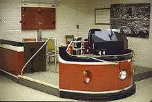
A mockup of a CLRV used to train new streetcar operators is located at Hillcrest.[48] The training simulator consists of an operator cab, front steps and part of the front of a streetcar.
In September 2014, Chris Bateman, writing in the Toronto Life magazine, described being allowed to try out the new simulator designed for the Flexity vehicles.[48] It provides an accurate mockup of the driver's cab of the Flexity vehicle, with a wrap-around computer screen that provides a convincing simulcra of Toronto streets. Like an aircraft cockpit simulator, this Flexity simulator provides realistic tactile feedback to the driver-trainee. The trainer can alter the simulated weather, the track friction, and can introduce more simulated vehicles on the simulated roadway, and even have badly behaved pedestrians and vehicles unpredictably block the Flexity's path.
Bateman wrote that the analogue simulator for the CLRVs was being retired.[48]
Operators also train with a real streetcar. Front and rear rollsigns on the vehicle identify it as a training car.
Blacksmith
Given that the TTC's streetcar rolling stock has been ageing, many parts used by the rolling stock are no longer available. The system has a blacksmith who crafts parts and tools used to maintain the fleet.[49] With the introduction of the new Flexity LRVs, this job may become obsolete.
See also
- Toronto Transit Commission bus system
- Toronto rapid transit
- Queen subway line
- Light rail in Canada
- List of North American light rail systems by ridership
- Streetcars in North America (for other streetcar lines in North America)
- Metrolinx light rail projects in Toronto (formerly Transit City)
- TTC Peter Witt streetcar
- TTC Birney Cars (a model of streetcars operated by the TTC)
- TTC Flexity Outlook
References
Inline citations
- 1 2 3 "Toronto's Streetcar Network - Past to Present - History". 2013. Retrieved 2013-07-26.
- 1 2 3 "2013 TTC Operating Statistics". Toronto Transit Commission. 2014. Retrieved 2014-10-04.
- ↑ "Transit Ridership Report Second Quarter 2014" (PDF). American Public Transportation Association (APTA). August 27, 2014. p. 34. Retrieved 2014-10-04.
- 1 2 "Public Transportation Ridership Report Fourth Quarter 2013" (PDF). American Public Transportation Association (APTA). February 26, 2014. p. 31. Retrieved 2014-03-14.
- ↑ http://www.urbanrail.net/am/toro/tram/toronto-tram.htm
- ↑ The Canadian Light Rail Vehicles - Transit Toronto
- ↑ Costa, Alvaro; Fernandes, Ruben (February 2012). "Urban public transport in Europe: Technology diffusion and market organisation". Transportation Research Part A: Policy and Practice. 46 (2): 269–284. doi:10.1016/j.tra.2011.09.002. Retrieved 13 February 2015.
- ↑ William Bragg (November 13, 1967). "Our Streetcars are Near the End of the Line". Toronto Star. p. 7.
- ↑ Craig Cal. "'Streetcars for Toronto' – 35th Anniversary" Spacing December 1, 2007.
- ↑ Steve Munro (2009-10-25). "Streetcar Track Replacement Plan 2010-2014". Steve Munro. Retrieved 2009-10-25.
- ↑ Gay Abbate (2003-07-14). "State of tracks forces streetcars to crawl". The Globe and Mail. Retrieved 2003-07-14.
- ↑ Lloyd Alter (2013-11-25). "Streetcars save cities: A look at 100 years of a Toronto streetcar line". TreeHugger. Archived from the original on 2013-11-26. Retrieved 2013-11-25.
A hundred years ago, a new streetcar line was installed on St. Clair Avenue in Toronto in a dedicated right-of-way. In 1928 they got rid of the right-of-way to make more room for cars; In 2006 they rebuilt it again, putting the right of way back.
- ↑ "Lanes, tracks and bikes". Roncesvalles Village BIA.
- ↑ Steve Munro (2010-12-19). "Parliament and Roncesvalles 2010 Track Work". Steve Munro. Retrieved 2010-12-19.
- ↑ Tess Kalinowski (2007-12-11). "Transit-first street plan hailed". Toronto Star. Retrieved 2012-07-19.
Unlike Toronto's other streetcar routes, which traditionally run in mixed traffic and board passengers from platforms in the middle of the road, the Cherry St. plan calls for putting all the transit on the east side of the street, running in two directions, with a tree-lined platform separating it from other traffic.
"Two figures incorrect in Cherry St. transit plan". Toronto Star. 2007-12-12. Retrieved 2012-07-19.The transitway envisioned for this section is 700 metres.
- ↑ "STREETCARS ON CHERRY STREET AND SUMACH STREET SERVING THE WEST DON LANDS DEVELOPMENT" (PDF). Toronto Transit Commission. 2007-12-06. Retrieved 2012-07-20.
- ↑ Adrian Morrow (2012-05-25). "A tiny perfect streetcar line is being laid along Cherry Street". The Globe and Mail. Retrieved 2012-07-19.
There’s a new streetcar line under construction in Toronto, the first in more than a decade and a surprising development during the tenure of a mayor who is outspokenly opposed to light rail.
- ↑ Steve Munro (2014-10-12). "Streetcars Return to Queens Quay". Steve Munro. Retrieved 2014-10-12.
- ↑ Eric Andrew-Gee, reporter (2015-05-07). "Sunday streetcar stops near churches to be shuttered in June". Toronto Star. Retrieved 2015-05-07.
- ↑ "TTC's new streetcar facility to enter service this Sunday". Toronto Transit Commission. 2015-11-20.
- ↑ "Proof-of-Payment (POP)". Toronto Transit Commission. Retrieved 2015-12-06.
- ↑ Steve Munro (2015-12-04). "TTC Service Changes Effective January 3, 2016". Retrieved 2015-12-06.
- ↑ New TTC service are here
- ↑ Schoolchildren returning from field trip hurt in streetcar crash: report
- 1 2 Doherty, Brennan (June 18, 2016). "TTC launches new 514 Cherry St. streetcar route". thestar.com. Toronto Star. Retrieved June 18, 2016.
- ↑ "Improved_Transit_Service_in_EastCentral_Downtown_514_Cherry_.pdf" (PDF). TTC. March 23, 2016. Retrieved April 17, 2016.
- ↑ "Relief could be coming to King streetcar in June". CBC News. 2016-03-16. Retrieved 2016-03-16.
A report made public Wednesday recommends that the new route begin service on June 19. It would operate between the Distillery Loop in the east and the Dufferin Gates loop in the west via Cherry, King and Dufferin streets.
- ↑ Bow, James (2006-11-10). "Route 509 - The New Harbourfront Streetcar". Transit Toronto. Retrieved 2007-07-21.
- ↑ Route 512 - The St Clair Streetcar
- ↑ http://www3.ttc.ca/Service_Advisories/Construction/St_Clair_Avenue_West_Transit_Improvements_Project_-_Phase_4.jsp
- ↑ Kalinowski, Tess (30 June 2010). "Finally, St. Clair streetcar fully restored". The Star. Toronto.
- ↑ http://transit.toronto.on.ca/streetcar/4155.shtml
- ↑ "Transit City". City of Toronto. Retrieved 2007-07-21.
- 1 2 "Waterfront Transit "Reset"" (PDF). City of Toronto. October 9, 2015. Retrieved 2015-11-06.
- ↑ "Port Lands + South of Eastern - Transportation + Servicing" (PDF). Waterfront Toronto. November 11, 2015. Retrieved 2015-11-20.
- ↑ John F. Bromley (25 October 2001). "Toronto Street Railway Routes". Transit Canada. Retrieved 9 January 2011.
- ↑ Pursley, Louis H. (1958). Street Railways of Toronto: 1861–1921. Los Angeles: Interurbans Press. pp. 39–45.
- ↑ James Bow (2012-04-03). "The Ashbridge Streetcar (Deceased)". Transit Toronto. Retrieved 2012-07-19.
- ↑ "The Toronto Civic Railways", UCRS Bulletin, Toronto: Upper Canada Railway Society (26), pp. 1–2
- ↑ "A History of Toronto's Presidents' Conference Committee Cars (the PCCs) - Transit Toronto - Content". transit.toronto.on.ca. Retrieved 2016-04-18.
- 1 2 http://www.cbc.ca/news/canada/toronto/some-ttc-streetcars-out-of-service-due-to-cold-weather-1.2893670
- 1 2 Tess Kalinowski (2010-01-06). "Transit City measures up to international standard". Toronto Star. Archived from the original on 2013-08-06. Retrieved 2013-08-06.
TTC gauge is `English carriage gauge' and was used in Toronto well before the TTC was formed," explains transit blogger Steve Munro. "There were two purposes: One was to make it impossible for the steam railways to use city tracks and the other (alleged) was to allow carriages and wagons to drive on the tracks when roads were impassable due to mud.
- 1 2 "FAQ - STREETCARS", Transit Toronto, 3 January 2003
- ↑ Raymond L. Kennedy (2009). "The Junction and Its Railways". TrainWeb. Retrieved 2016-04-16.
- ↑ James V. Salmon (1958). Rails from the Junction. Lyon Productions. p. 7. Retrieved 2016-04-16.
- ↑ City solicitor (1892). "The charter of the Toronto Railway Company". City of Toronto. p. 21. Retrieved 2016-04-16.
- ↑ "Ashbridges Bay Light Rail Vehicle (LRV) Maintenance and Storage Facility". Toronto Transit Commission. May 2010. Retrieved 16 August 2011.
- 1 2 3 Chris Bateman (2014-09-29). "The TTC's new life-sized streetcar simulator is not a toy—but it looks like one". Toronto Life. Archived from the original on 2014-09-30.
Halfway down a long corridor inside the TTC’s Hillcrest facility, on Bathurst Street, there’s a room marked "streetcar simulator." Inside is a state-of-the-art training device on which the next generation of TTC streetcar drivers will earn their wheels.
- ↑ http://www.cbc.ca/news/canada/toronto/meet-pat-maietta-the-ttc-s-last-remaining-blacksmith-1.2513352
Other references
- Jeff Gray (June 23, 2005). "TTC to shop for new streetcars". The Globe and Mail.
- "Future Streetcar Fleet Requirements and Plans". Toronto Transit Commission. June 22, 2005.
- Livett, Christopher. "Toronto's Streetcar System (schematic track map)". Transit Toronto.
- Tess Kalinowski (April 28, 2009). "A streetcar named Inspire?". Toronto Star. Retrieved 2014-10-04. – includes a timeline of the history of the Toronto streetcar system
- "Opportunities for New Streetcar Routes" (PDF). Toronto Transit Commission. January 21, 1997.
- "North America - Canada - Ontario - Toronto Streetcar (Tram)". UrbanRail.Net. 2012. Retrieved 2013-07-26.
External links
| Wikimedia Commons has media related to Trams in Toronto. |
- Toronto Transit Commission
- TTC Transit City - LRT expansion proposals
- TTC's web site for its new vehicle procurement program
- Siemens's proposal for Toronto's new streetcar fleet
- Transit Toronto Streetcar Pages
- The Toronto LRT Information Page
- TTC Schedules by Route Name
- Geographically accurate map on Google Maps
| Intercity | |||||||
|---|---|---|---|---|---|---|---|
| Sightseeing | |||||||
| Commuter rail |
| ||||||
| Rapid transit | |||||||
| Light rail |
| ||||||
| People mover |
| ||||||
| Streetcar | |||||||
| Heritage tramways | |||||||
| See also |
| ||||||
| Bus |  _(14918534190).jpg) | |
|---|---|---|
| Subway | ||
| Streetcars | ||
| History | ||
| Predecessors |
| |
| Facilities | ||
| Proposed | ||
| Miscellaneous | ||
Italics indicate a project under construction | ||