Toronto, Kansas
| Toronto, Kansas | |
|---|---|
| City | |
 Location within Woodson County and Kansas | |
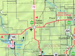 KDOT map of Woodson County (legend) | |
| Coordinates: 37°47′55″N 95°56′58″W / 37.79861°N 95.94944°WCoordinates: 37°47′55″N 95°56′58″W / 37.79861°N 95.94944°W | |
| Country | United States |
| State | Kansas |
| County | Woodson |
| Government | |
| • Type | Mayor–Council |
| Area[1] | |
| • Total | 0.36 sq mi (0.93 km2) |
| • Land | 0.36 sq mi (0.93 km2) |
| • Water | 0 sq mi (0 km2) |
| Elevation | 951 ft (290 m) |
| Population (2010)[2] | |
| • Total | 281 |
| • Estimate (2015)[3] | 261 |
| • Density | 780/sq mi (300/km2) |
| Time zone | Central (CST) (UTC-6) |
| • Summer (DST) | CDT (UTC-5) |
| ZIP code | 66777 |
| Area code | 620 |
| FIPS code | 20-71050 [4] |
| GNIS feature ID | 0474672 [5] |
Toronto is a city in Woodson County, Kansas, United States, along the Verdigris River. As of the 2010 census, the city population was 281.[6]
History
Toronto was founded in 1869. It was named after the city of Toronto, Ontario.[7] The name is derived from the Mohawk word tkaronto, meaning "place where trees stand in the water", which lies at the meeting of several rivers. A coal baron with land in County Durham was visiting the Canadian city when he was told that coal had been discovered under his land. He therefore decided to call the mine Toronto, whence the village also took its name. In the Toronto Township Cemetery, John C. Woods is buried. He was the hangman at the Nuremberg Trials.
Geography
Toronto is located at 37°47′55″N 95°56′58″W / 37.79861°N 95.94944°W (37.798598, -95.949555).[8] According to the United States Census Bureau, the city has a total area of 0.36 square miles (0.93 km2), all of it land.[1]
Climate
The climate in this area is characterized by hot, humid summers and generally mild to cool winters. According to the Köppen Climate Classification system, Toronto has a humid subtropical climate, abbreviated "Cfa" on climate maps.[9]
Demographics
| Historical population | |||
|---|---|---|---|
| Census | Pop. | %± | |
| 1880 | 88 | — | |
| 1890 | 552 | 527.3% | |
| 1900 | 695 | 25.9% | |
| 1910 | 627 | −9.8% | |
| 1920 | 829 | 32.2% | |
| 1930 | 706 | −14.8% | |
| 1940 | 737 | 4.4% | |
| 1950 | 600 | −18.6% | |
| 1960 | 524 | −12.7% | |
| 1970 | 431 | −17.7% | |
| 1980 | 466 | 8.1% | |
| 1990 | 317 | −32.0% | |
| 2000 | 312 | −1.6% | |
| 2010 | 281 | −9.9% | |
| Est. 2015 | 261 | [3] | −7.1% |
| U.S. Decennial Census | |||
2010 census
As of the census[2] of 2010, there were 281 people, 149 households, and 72 families residing in the city. The population density was 780.6 inhabitants per square mile (301.4/km2). There were 234 housing units at an average density of 650.0 per square mile (251.0/km2). The racial makeup of the city was 96.4% White, 1.1% Native American, 0.7% from other races, and 1.8% from two or more races. Hispanic or Latino of any race were 2.5% of the population.
There were 149 households of which 18.8% had children under the age of 18 living with them, 33.6% were married couples living together, 9.4% had a female householder with no husband present, 5.4% had a male householder with no wife present, and 51.7% were non-families. 45.6% of all households were made up of individuals and 26.2% had someone living alone who was 65 years of age or older. The average household size was 1.89 and the average family size was 2.63.
The median age in the city was 53.5 years. 17.4% of residents were under the age of 18; 6.2% were between the ages of 18 and 24; 15.6% were from 25 to 44; 32.4% were from 45 to 64; and 28.5% were 65 years of age or older. The gender makeup of the city was 50.9% male and 49.1% female.
2000 census
As of the census[4] of 2000, there were 312 people, 171 households, and 80 families residing in the city. The population density was 840.1 people per square mile (325.6/km²). There were 245 housing units at an average density of 659.7 per square mile (255.7/km²). The racial makeup of the city was 97.44% White, 0.64% Native American, and 1.92% from two or more races. Hispanic or Latino of any race were 0.64% of the population.
There were 171 households out of which 16.4% had children under the age of 18 living with them, 40.9% were married couples living together, 5.8% had a female householder with no husband present, and 53.2% were non-families. 48.5% of all households were made up of individuals and 28.7% had someone living alone who was 65 years of age or older. The average household size was 1.82 and the average family size was 2.60.
In the city the population was spread out with 17.3% under the age of 18, 3.2% from 18 to 24, 15.7% from 25 to 44, 29.5% from 45 to 64, and 34.3% who were 65 years of age or older. The median age was 55 years. For every 100 females there were 88.0 males. For every 100 females age 18 and over, there were 85.6 males.
The median income for a household in the city was $19,643, and the median income for a family was $26,667. Males had a median income of $23,500 versus $13,929 for females. The per capita income for the city was $14,960. About 12.5% of families and 15.9% of the population were below the poverty line, including 11.5% of those under age 18 and 5.7% of those age 65 or over.
See also
References
- 1 2 "US Gazetteer files 2010". United States Census Bureau. Retrieved 2012-07-06.
- 1 2 "American FactFinder". United States Census Bureau. Retrieved 2012-07-06.
- 1 2 "Annual Estimates of the Resident Population for Incorporated Places: April 1, 2010 to July 1, 2015". Retrieved July 2, 2016.
- 1 2 "American FactFinder". United States Census Bureau. Retrieved 2008-01-31.
- ↑ "US Board on Geographic Names". United States Geological Survey. 2007-10-25. Retrieved 2008-01-31.
- ↑ "2010 City Population and Housing Occupancy Status". U.S. Census Bureau. Retrieved June 19, 2011.
- ↑ Kansas State Historical Society (1916). Biennial Report of the Board of Directors of the Kansas State Historical Society. Kansas State Printing Plant. p. 316.
- ↑ "US Gazetteer files: 2010, 2000, and 1990". United States Census Bureau. 2011-02-12. Retrieved 2011-04-23.
- ↑ Climate Summary for Toronto, Kansas
External links
| Wikimedia Commons has media related to Toronto, Kansas. |
- City
- Schools
- USD 389, local school district
- Maps
- Toronto City Map, KDOT
Municipalities and communities of Woodson County, Kansas, United States | ||
|---|---|---|
| Cities | 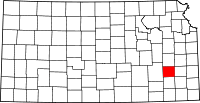 | |
| CDP | ||
| Unincorporated communities | ||