Topalu
| Topalu | |
|---|---|
| Commune | |
 Topalu Location of Topalu | |
| Coordinates: 44°33′0″N 28°3′0″E / 44.55000°N 28.05000°ECoordinates: 44°33′0″N 28°3′0″E / 44.55000°N 28.05000°E | |
| Country |
|
| County | Constanța County |
| Status | Commune |
| Component villages | Topalu, Capidava |
| Government | |
| • Mayor | Valentin Stanciu[1] (National Liberal Party) |
| Area | |
| • Total | 79.29 km2 (30.61 sq mi) |
| Population (2011[2]) | |
| • Total |
|
| Time zone | EET (UTC+2) |
| • Summer (DST) | EEST (UTC+3) |
| Website | http://www.primariatopalu.ro |
Topalu is a commune located on the right bank of the Danube in Constanţa County, Dobruja, Romania.
Administration
The commune includes two villages:
Demographics
At the 2011 census, Topalu had 1,707 Romanians (99.94%), 1 others (0.06%).[2]
History
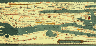
Tabula Peutingeriana
Capidava is depicted in the form Calidava/Calidaua in Segmentum VIII of Tabula Peutingeriana (1st-4th century AD) on a Roman road between Axiopolis and Carsium.[3][4] The map provides accurate data on the distances between Axiopolis, Capidava and Carsium. These distances coincide with the distances between the present localities of Hinog - Capidava and Capidava - Hârşova. This is also verified by the discovery of military marking pillar at Seimenii Mici that indicates the distance of 18,000 feet (27 km) from Axiopolis to Capidava.[5]
Ancient times
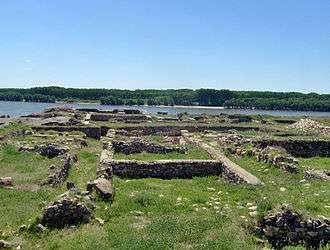
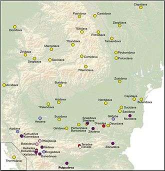
The village Capidava is the site of the fortified Geto-Dacian center with the same name, Capidava.
After the Roman conquest of Dacia it became a Roman city and castra in the province of Scythia Minor (modern Dobruja).
Etymology
Capidava is a Getic toponym, meaning the "curve fortified settlement".[5]
See also
- Dacia
- Roman Dacia
- List of ancient towns in Scythia Minor
- List of ancient cities in Thrace and Dacia
- Dacian davae
Notes
- ↑ "Rezultate finale în judeţul Constanţa. Iată care sunt noii primari din judeţ!" (in Romanian). Ziua de Constanța. 6 June 2016. Retrieved 6 June 2016.
- 1 2 "Constanta County at the 2011 census" (PDF) (in Romanian). INSSE. February 2, 2012. Retrieved March 8, 2012.
- ↑ Tabula Peutingeriana, Segmentum VIII,3.
- ↑ Olteanu, Toponyms.
- 1 2 Capidava cIMeC.
References
Ancient
- Anonymous (1-4th century AD). Tabula Peutingeriana (in Latin). Check date values in:
|date=(help)
Modern
- Florescu, Radu; Manea, Florentina. Oberländer-Târnoveanu, Irina; Bor, Corina, eds. "Capidava". Bucharest, Romania: Institute for Cultural Memory (Institutul de Memorie Culturală) - cIMeC. Archived from the original on 2 February 2011. Retrieved 2 February 2011.
- Olteanu, Sorin. "Linguae Thraco-Daco-Moesorum - Toponyms Section". Linguae Thraco-Daco-Moesorum (in Romanian and English). Archived from the original on 3 January 2010. Retrieved 3 January 2010.
Further reading
- Florescu, Radu; Manea, Florentina. Oberländer-Târnoveanu, Irina; Bor, Corina, eds. "Capidava". Bucharest, Romania: Institute for Cultural Memory (Institutul de Memorie Culturală) - cIMeC. Archived from the original on 2 February 2011. Retrieved 2 February 2011.
- Grumeza, Ion (2009). Dacia: Land of Transylvania, Cornerstone of Ancient Eastern Europe. Hamilton Books. ISBN 0-7618-4465-1.
The shores of the Danube were well monitored from the Dacian fortresses Acidava, Buricodava, Dausadava (the shrine of the wolves), Diacum, Drobeta (Turnu Severin), Nentivava (Oltenita), Suvidava (Corabia), Tsirista, Tierna/Dierna (Orsova) and what is today Zimnicea. Downstream were also other fortresses: Axiopolis (Cernadova), Barbosi, Buteridava, Capidava(Topalu), Carsium(Harsova), Durostorum(Silistra), Sacidava/Sagadava (Dunareni) along with still others...
- Early Byzantine Capidava
- Official Capidava Archaeological Site
- Official Capidava Fortress Site at Constanţa County Council
- Capidava at Encyclopedia Dacica
- Capidava at Turism Constanţa - hosted by the The Public Office for Tourism, Commerce and Public Services, part of the Constanţa County Council
- Capidava - hosted by the Romanian National Institute of Historical Monuments
- Capidava article at ziare.com
External links
| Wikimedia Commons has media related to Capidava. |
| Wikimedia Commons has media related to Dacia and Dacians. |
| Wikimedia Commons has media related to Capidava. |
- Official Capidava Archaeological Site
- Official Capidava Fortress Site at Constanţa County Council
- Capidava at Encyclopedia Dacica
- Capidava at Turism Constanţa - hosted by the The Public Office for Tourism, Commerce and Public Services, part of the Constanţa County Council
- Capidava - hosted by the Romanian National Institute of Historical Monuments
- Capidava article at ziare.com