Tomer
| Tomer תֹּמֶר, תומר | |
|---|---|
|
Tomer (left) next to Fasayil (right) | |
 Tomer | |
| Coordinates: 32°1′7.33″N 35°26′20″E / 32.0187028°N 35.43889°ECoordinates: 32°1′7.33″N 35°26′20″E / 32.0187028°N 35.43889°E | |
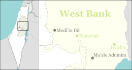
| District | Judea and Samaria Area |
| Council | Bik'at HaYarden |
| Region | West Bank |
| Affiliation | Moshavim Movement |
| Founded | 1976 |
| Population (2015)[1] | 247 |
| Name meaning | Palm Tree |
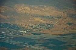
Tomer (Hebrew: תֹּמֶר, lit. Palm Tree) is a moshav and Israeli settlement in the West Bank.[2] Located in the Jordan Valley next to the Palestinian village of Fasayil, it falls under the jurisdiction of Bik'at HaYarden Regional Council.[2] In 2015 it had a population of 247.
The international community considers Israeli settlements in the West Bank illegal under international law, but the Israeli government disputes this.[3][4][5][6]
History
The village was established in 1976,[7] and was named after the trees common in the area. In March 1978 it moved to its present location near Highway 90.
References
- ↑ "List of localities, in Alphabetical order" (PDF). Israel Central Bureau of Statistics. Retrieved 16 October 2016.
- 1 2 "The Jordan Valley – A General Description". Bik'at HaYarden Regional Council. Retrieved July 15, 2012.
- ↑ "The Geneva Convention". BBC News. 10 December 2009. Retrieved 27 November 2010.
- ↑ "Israel prepares for 'fallow' new year". BBC News. 12 September 2007.
- ↑ Committee on the Exercise of the Inalienable Rights of the Palestinian People (1 July 1984). "Israeli Settlements in Gaza and the West Bank (including Jerusalem); Their Nature and Purpose, Part II". United Nations.
- ↑ "Another brick in the wall: Saving schools in the West Bank". The Independent. 22 November 2007.
- ↑ "Tomer". Israeli Settlements in Judea and Samaria. Retrieved July 15, 2012.
This article is issued from Wikipedia - version of the 10/19/2016. The text is available under the Creative Commons Attribution/Share Alike but additional terms may apply for the media files.