Tjørnuvík
| Tjørnuvík | |
|---|---|
| Village | |
|
Tjørnuvík, Faroe Islands | |
 Tjørnuvík Location in the Faroe Islands | |
| Coordinates: 62°17′17″N 7°8′27″W / 62.28806°N 7.14083°WCoordinates: 62°17′17″N 7°8′27″W / 62.28806°N 7.14083°W | |
| State |
|
| Constituent country |
|
| Island | Streymoy |
| Municipality | Sunda Municipality |
| Population (1 January 2006) | |
| • Total | 71 |
| Time zone | GMT |
| • Summer (DST) | EST (UTC+1) |
| Postal code | FO 445 |
| Climate | ET |
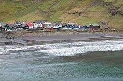
Tjørnuvík (Danish: Tjørnevig) is the northernmost village on the Faroese island of Streymoy in Sunda Municipality.
The 2002 population was 64. Its postal code is FO 445. Its current church was built in 1937.
External links
See also
| Wikimedia Commons has media related to Tjørnuvík. |
This article is issued from Wikipedia - version of the 6/15/2016. The text is available under the Creative Commons Attribution/Share Alike but additional terms may apply for the media files.