Tinghir
| Tinghir ⵜⵉⵏⵖⵉⵔ Toudgha | |
|---|---|
| Tineghir transcription(s) | |
 | |
| Nickname(s): tdghot | |
 Tinghir Location in Morocco | |
| Coordinates: 31°30′53″N 5°31′58″W / 31.51472°N 5.53278°WCoordinates: 31°30′53″N 5°31′58″W / 31.51472°N 5.53278°W | |
| Country |
|
| Region | Drâa-Tafilalet |
| Province | Tinghir |
| Population (2014) | |
| • Total | 42,044 |
| Time zone | WET (UTC+0) |
| • Summer (DST) | WEST (UTC+1) |
Tinghir or Tinerhir (Arabic: تنغير, Tamazight: ⵜⵉⵏⵖⵉⵔ) is a city in the region of Drâa-Tafilalet, south of the High Atlas and north of the Little Atlas in southeastern Morocco. It is the capital of Tinghir Province. Its name originally referred to the foothills of the Atlas Mountains, but its area has expanded to encompass surrounding villages and refers to the entire oasis.
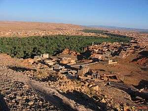
The city of Tinghir (Baladia tinghir) has a population of 42 044 and the province has 322 412 inhabitants, according to the 2014 census. The predominant ethnic group is Amazighs, and the city is at the center of one of the most attractive oases in southern Morocco. Lush palm trees cover about 30 miles (48 km) on 500-to-1,500-metre (550 to 1,640 yd)-wide tracts along the Wadi Todgha. After the Todra Gorge, Wadi Todgha has a difficult passage along the southern slopes of the Atlas Mountains (Tizgui); it then flows across the plain, meandering slightly over 20 kilometres (12 mi) to Ferkla. The palm oasis, dense and widespread, is irrigated by a network of pipes and irrigation canals. Occasional heavy rains are absorbed in a few days.
Economy
The economy of Tinghir is based on agriculture, trade and tourism. In addition, many families live on money sent home by relatives working in Europe. Social and cultural activities are increasing; education projects for young children are increasing in many villages, as well as literacy projects aimed at adults (particularly women). These projects are supported by local and nongovernmental organisations.
Geography
.jpg)
Tinghir is an oasis about 30 kilometres (19 mi) long and about 4 kilometres (2.5 mi) wide. The climate is arid subtropical: hot, dry winters in relation to altitude (1,430 metres (4,690 ft)). There are a few rainy days per year, with the greatest precipitation in fall and winter.
The Tinghir region is wedged between two mountain ranges, stretching over 700 kilometres (430 mi) southwest to northeast Morocco: the High Atlas in the north, with a high peak over 4,167 metres (13,671 ft), and the Little Atlas in the south. The road from Ouarzazate to Imtghren parallels the mountains. During the Mesozoic the region was invaded by the sea, where thick deposits of sediments rich in marine fossils (particularly of the ammonitida class). The uplift of the Atlas Mountains (primarily during the Neogene) caused the withdrawal of the sea and the deformation of rocks into folds and faults. Wind and river erosion eventually shaped the desert landscape of limestone and clay. The Todgha River has widened these layers of rock, giving rise to canyons 300 metres (980 ft) high but in some places only 10 metres (33 ft) wide. The river widens, developing an oasis edged with the red ochre of the desert.
Government
King Mohammed VI gave his approval on 21 January 2009 to make Tinghir an administrative center, an initiative which met the needs of its inhabitants; it provides a legal and institutional framework for reform of territorial administration based on good governance and local self-administration.
External links
| Wikimedia Commons has media related to Tineghir. |
Capital: Errachidia | ||
| Provinces |  | |
| Cities | ||