Timeline of town creation in Central New York

| Part of a series on |
| Regions of New York |
|---|
 |
|
Timelines of town creation
|
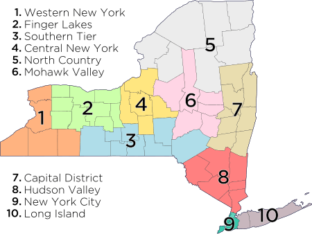
The towns and cities of Central New York were created by the U.S. state of New York as municipalities in order to give residents more direct say over local government.[1] Central New York (consisting of the Syracuse Consolidated Metropolitan Statistical Area and the Utica-Rome Metropolitan Statistical Area) is a six county area–Cayuga, Herkimer, Madison, Oneida, Onondaga, and Oswego.
The entire area was nominally under the jurisdiction of Albany County from 1686 until the Royal Proclamation of 1763 but truly under the Iroquois Confederacy until 1777. The area was then nominally Tryon County from 1781 and effectively in 1784 when the county was renamed Montgomery, and then the area was part of Herkimer County from 1791.[2][3]

In 1794 the western section of Herkimer County was split off as Onondaga County, and then in 1798 the northwestern section of Herkimer was removed as Oneida County and the southwestern section as Chenango County. Cayuga County was removed from Onondaga in 1799, Madison County from Chenango in 1806, and Oswego from Onondaga and Oneida in 1816.[2]
The current towns of Herkimer, Oneida, and Madison counties are descended from the original districts and towns of Montgomery County; whereas the towns of Onondaga and Cayuga counties are descended from the towns erected by the state when Onondaga County was formed from the Military Tract in western Herkimer County which had previously been divided into townships for the purpose of surveying of lands to be sold to veterans of the US Revolutionary War.
New York experimented with different types of municipalities before settling upon the current format of towns and cities occupying all the land in a county,[4] and all previous forms were transformed into towns (or divided into multiple towns) in 1788 when all of the state of New York was divided into towns.[1] Some early forms of government in earlier years included land patents with some municipal rights, districts,[5] precincts,[6] and boroughs.[7] Though originally intended to be mere “…involuntary subdivisions of the state, constituted for the purpose of the more convenient exercise of governmental functions by the state for the benefit of all its citizens” as defined by the courts in 1916 (Short v. Town of Orange), towns gained home rule powers from the state in 1964, at which time towns became "a municipal corporation comprising the inhabitants within its boundaries, and formed with the purpose of exercising such powers and discharging such duties of local government and administration of public affairs as have been, or, maybe [sic] conferred or imposed upon it by law.”[8]
The following is a timeline showing the creation of the current towns from their predecessors stretching back to the earliest municipal entity over the area. The timelines only represent from which town(s) a particular town was created from and does not represent annexations of territory to and from towns that already existed. All municipalities are towns unless otherwise noted as patent, township, borough, district, or city.
Cayuga County

| Aurelius 1794[9] | Auburn 1823-1848[10] | Auburn City 1848[10] | |||||||||||||||||||||||||||
| Brutus 1802[10] | Sennett 1827[10] | Throop 1859[10] | |||||||||||||||||||||||||||
| Cato 1802[10] | Sterling 1812[10] | ||||||||||||||||||||||||||||
| Conquest 1812[10] | |||||||||||||||||||||||||||||
| Ira 1821[10] | |||||||||||||||||||||||||||||
| Victory 1812[10] | |||||||||||||||||||||||||||||
| Jefferson 1802 (Mentz from 1808)[10] | Montezuma 1859[10] | ||||||||||||||||||||||||||||
| Owasco 1802[10] | |||||||||||||||||||||||||||||
| Fleming 1823[10] | |||||||||||||||||||||||||||||
| Springport 1823[10] | |||||||||||||||||||||||||||||
| Scipio 1794[10] | Venice 1823[10] | ||||||||||||||||||||||||||||
| Ledyard 1823[10] | |||||||||||||||||||||||||||||
| Sempronius 1799[10] | Moravia 1833[10] | ||||||||||||||||||||||||||||
| Niles 1833[10] | |||||||||||||||||||||||||||||
| Milton 1794[9] (Genoa from 1808)[10] | Locke 1802[10] | Plato 1831 (Summer Hill from 1832)[10] | |||||||||||||||||||||||||||
- Notes
| [A] = A part of Montgomery County until 1791, then Herkimer County from 1791-1794, Onondaga County from 1794-1799, and Cayuga County from 1799 and thereafter. | |||||
| [B] = A part of Onondaga County until 1799 thereafter Cayuga County. | |||||
| [C] = A part of Cayuga County. | |||||
- Prior to the creation of Onondaga County the western section of Herkimer County was the Military Tract. This tract included present-day Onondaga, Cayuga, and Seneca counties, and parts of Oswego, Tompkins, and Wayne; and was divided into 25 townships for surveying purposes to provide land for veterans of the US Revolutionary War. Three more townships were created in order to settle all claims.[10] Originally simply numbered, they latter received names, mostly classical Greek and Roman names. In creating Onondaga County in 1794 the state of New York combined the townships into 11 towns.[9] Milton (17), Locke (18), Scipio (12), Sempronius (13), Cato (3), Brutus (4), and Aurelius (8) were the townships in present-day Cayuga County, which were combined in 1794 into the towns of Milton (Milton and Locke townships), Scipio (Scipio and Sempronius townships), and Aurelius (Cato, Brutus, and Aurelius townships).
Herkimer County
| German Flatts District 1772-1788 (Kingsland from 1773)[10] | German Flatts 1788[10] | Frankfort 1796[10] | |||||||||||||||||||||||||||||||||||||||||||
| Warren 1796[10] | Columbia 1812[10] | ||||||||||||||||||||||||||||||||||||||||||||
| Litchfield 1796[10] | |||||||||||||||||||||||||||||||||||||||||||||
| Winfield 1816[10] | |||||||||||||||||||||||||||||||||||||||||||||
| Richfield 1792[10] | Plainfield 1799[10] | ||||||||||||||||||||||||||||||||||||||||||||
| Otsego 1788[10] | For further descendants see Otsego County. | For further descendants see Otsego County | |||||||||||||||||||||||||||||||||||||||||||
| Little Falls 1829[10] | Little Falls City 1895 | ||||||||||||||||||||||||||||||||||||||||||||
| For further descendants see Oneida County | |||||||||||||||||||||||||||||||||||||||||||||
| Schuyler 1792[10] | Newport 1806[10] | ||||||||||||||||||||||||||||||||||||||||||||
| Kingsland Precinct 1772-1788 (German Flatts from 1773)[10] | Herkimer 1788[10] | Norway 1792[10] | Fairfield 1796[10] | ||||||||||||||||||||||||||||||||||||||||||
| West Brunswick 1823 (Ohio from 1836)[10] | |||||||||||||||||||||||||||||||||||||||||||||
| For further descendants see Oneida County | Union 1806 (Russia from 1808)[10] | Wilmurt 1836[10]-1896 | Webb 1896 | ||||||||||||||||||||||||||||||||||||||||||
| Stone Arabia Precinct 1772-1788 (Palatine from 1773)[10] | Palatine 1788[10] | Salisbury 1797[10] | |||||||||||||||||||||||||||||||||||
| Manheim 1817[10] | |||||||||||||||||||||||||||||||||||||
| Canajoharie Precinct 1772-1788[10] | Canajoharie 1788[10] | Minden 1798[10] | Danube 1817[10] | Stark 1828[10] | |||||||||||||||||||||||||||||||||
- Notes
| [A] = A part of Montgomery (Named Tryon County prior to 1784). | |||||
| [B] = A part of Montgomery County until 1791, thereafter Herkimer County. | |||||
| [C] = A part of Montgomery County until 1791, thereafter Otsego County. | |||||
| [D] = A part of Otsego County. | |||||
| [E] = A part of Montgomery County until annexed to Herkimer County in 1817. | |||||
| [F] = A part of Herkimer County. | |||||
| [G] = A part of Oneida County. | |||||
Madison County
| Oneida 1896–1901 | Oneida City 1901 | ||||||||||||||||||||||||||||||||||||||||||||||||||||
| Lincoln 1896[10] | |||||||||||||||||||||||||||||||||||||||||||||||||||||
| Sullivan 1803[10] | Lenox 1809[10] | ||||||||||||||||||||||||||||||||||||||||||||||||||||
| DeRuyter 1798[10] | Georgetown 1815[10] | ||||||||||||||||||||||||||||||||||||||||||||||||||||
| For further descendants see Oneida County | Stockbridge 1836[10] | ||||||||||||||||||||||||||||||||||||||||||||||||||||
| Whitestown 1788[10] | Cazenovia 1795[10] | Nelson 1807[10] | Smithfield 1807[10] | Fenner 1823[10] | |||||||||||||||||||||||||||||||||||||||||||||||||
| Paris 1792[10] | Brookfield 1795[10] | ||||||||||||||||||||||||||||||||||||||||||||||||||||
| Hamilton 1795[10] | Eaton 1807[10] | ||||||||||||||||||||||||||||||||||||||||||||||||||||
| For further descendants see Oneida County | Lebanon 1807[10] | ||||||||||||||||||||||||||||||||||||||||||||||||||||
| Madison 1807[10] | |||||||||||||||||||||||||||||||||||||||||||||||||||||
| Augusta 1798[10] | |||||||||||||||||||||||||||||||||||||||||||||||||||||
| Westmoreland 1792[10] | Vernon 1802[10] | ||||||||||||||||||||||||||||||||||||||||||||||||||||
| For further descendants see Oneida County | |||||||||||||||||||||||||||||||||||||||||||||||||||||
- Notes
| [A] = A part of Montgomery County until 1791, Herkimer County from 1791 to 1798, then Oneida County from 1798. | |||||
| [B] = A part of Herkimer County until 1798, Oneida County thereafter. | |||||
| [C] = A part of Herkimer County until 1798, then Chenango until 1806, thereafter Madison County. | |||||
| [D] = A part of Chenango County until 1806, then Madison County thereafter Oswego County. | |||||
| [E] = A part of Oneida County. | |||||
| [F] = A part of Madison County. | |||||
Oneida County
| For further descendants see Oswego County | |||||||||||||||||||||||||||||||||||||
| Whitestown 1788[10] | Utica 1817-1832[10] | Utica City 1832[10] | |||||||||||||||||||||||||||||||||||
| For further descendants see North Country | |||||||||||||||||||||||||||||||||||||
| Steuben 1792[10] | Leyden 1797[10] | Boonville 1805[10] | Ava 1846[10] | ||||||||||||||||||||||||||||||||||
| Western 1797[10] | Lee 1811[10] | ||||||||||||||||||||||||||||||||||||
| New Hartford 1827[10] | Floyd 1796[10] | ||||||||||||||||||||||||||||||||||||
| Rome 1796[10]-1870 | Rome City 1870 | ||||||||||||||||||||||||||||||||||||
| Paris 1792[10] | Sangerfield 1795[10] | Bridgewater 1797[10] | |||||||||||||||||||||||||||||||||||
| Kirkland 1827[10] | Marshall 1829[10] | ||||||||||||||||||||||||||||||||||||
| For further descendants see Madison County | For further descendants see Madison County | ||||||||||||||||||||||||||||||||||||
| For further descendants see Oswego County | |||||||||||||||||||||||||||||||||||||
| Mexico 1792[10] | Camden 1799[10] | Orange 1807 (Bengal from 1808-1816, Vienna from 1816)[10] | Annsville 1823[10] | ||||||||||||||||||||||||||||||||||
| For further descendants see North Country | |||||||||||||||||||||||||||||||||||||
| Augusta 1798[10] | For further descendants see Madison County | Florence 1805[10] | |||||||||||||||||||||||||||||||||||
| Verona 1802[10] | |||||||||||||||||||||||||||||||||||||
| Westmoreland 1792[10] | Vernon 1802[10] | Sherrill City 1916 | |||||||||||||||||||||||||||||||||||
| For further descendants see Madison County | |||||||||||||||||||||||||||||||||||||
| Kingsland 1772-1788 (German Flatts from 1773)[10] | Herkimer 1788[10] | Schuyler 1792[10] | Trenton 1797[10] | ||||||||||||||||||||||||||||||||||
| Deerfield 1798[10] | Marcy 1832[10] | ||||||||||||||||||||||||||||||||||||
| For further descendants see Herkimer County | |||||||||||||||||||||||||||||||||||||
| Norway 1792[10] | Remsen 1798[10] | Forestport 1869 | |||||||||||||||||||||||||||||||||||
| For further descendants see Herkimer County | For further descendants see Herkimer County | ||||||||||||||||||||||||||||||||||||
- Notes
| [A] = A part of Montgomery County (known as Tryon County prior to 1784). | |||||
| [B] = A part of Montomgery County until 1791, thereafter Herkimer County. | |||||
| [C] = A part of Montgomery County until 1791, Herkimer County from 1791 to 1798, then Oneida County from 1798. | |||||
| [D] = A part of Herkimer County until 1798, Oneida County thereafter. | |||||
| [E] = A part of Herkimer County. | |||||
| [F] = A part of Oneida County. | |||||
| [G] = A part of Madison County. | |||||
| [H] = A part of Herkimer County until 1798, then Oneida County until 1805, thereafter Lewis County. | |||||
| [I] = A part of Herkimer County until 1798, then Oneida County until 1816, thereafter Oswego County. | |||||
| [J] = A part of Oswego County. | |||||
- The city of Sherrill is considered in some circumstances of law to be a village under the jurisdiction of the town of Vernon.
Onondaga County

| Otisco 1806[10] | |||||||||||||||||||||||||||||||||||||
| Fabius 1798[10] | Tully 1803[10] | Spafford 1811[10] | |||||||||||||||||||||||||||||||||||
| Pompey 1794[9] | LaFayette 1825[10] | ||||||||||||||||||||||||||||||||||||
| Marcellus 1794[10] | Onondaga 1798[10] | ||||||||||||||||||||||||||||||||||||
| Salina 1809[10] | Geddes 1848[10] | ||||||||||||||||||||||||||||||||||||
| Manlius 1794[10] | DeWitt 1835[10] | Syracuse City 1847[10] | |||||||||||||||||||||||||||||||||||
| Skaneateles 1830[10] | Camillus 1799[10] | Van Buren 1829[10] | |||||||||||||||||||||||||||||||||||
| Elbridge 1829[10] | |||||||||||||||||||||||||||||||||||||
- Notes
- Prior to the creation of Onondaga County the western section of Herkimer County was the Military Tract. This tract included present-day Onondaga, Cayuga, and Seneca counties, and parts of Oswego, Tompkins, and Wayne; and was divided into 25 townships for surveying purposes to provide land for veterans of the US Revolutionary War. Three more townships were created in order to settle all claims.[10] Originally simply numbered, they latter received names, mostly classical Greek and Roman names. In creating Onondaga County in 1794 the state of New York combined the townships into 11 towns.[9] Pompey (10), Tully (14), Fabius (15), Manlius (7), Camillus (5), and Marcellus (9) occupied present-day Onondaga, and were combined as the towns of Pompey (Pompey, Tully, and Fabius townships), Marcellus (Camillus and Marcellus townships), and Manlius.[10]
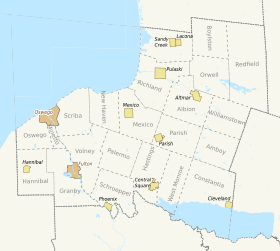
Oswego County
| Minetto 1916[11] | |||||||||||||||||||||||||||||||||||||||||||||
| Oswego 1818[10] | |||||||||||||||||||||||||||||||||||||||||||||
| Lysander 1794[10] | Hannibal 1806[10] | Granby 1818[10] | Fulton City 1902[12] | ||||||||||||||||||||||||||||||||||||||||||
| Oswego City 1848[10] | |||||||||||||||||||||||||||||||||||||||||||||
| Whitestown 1788[10] | Mexico 1792[10] | Fredericksburgh 1811 (Volney from 1806)[10] | Scriba 1811[10] | ||||||||||||||||||||||||||||||||||||||||||
| New Haven 1813[10] | Schroeppel 1832[10] | ||||||||||||||||||||||||||||||||||||||||||||
| For further descendants see Oneida County | Parish 1828[10] | Palermo 1832[10] | |||||||||||||||||||||||||||||||||||||||||||
| Williamstown 1804[10] | Amboy 1830[10] | ||||||||||||||||||||||||||||||||||||||||||||
| Richland 1807[10] | Albion 1825[10] | ||||||||||||||||||||||||||||||||||||||||||||
| Redfield 1800[10] | Greenboro 1843-1848[10] | Sandy Creek 1825[10] | |||||||||||||||||||||||||||||||||||||||||||
| Constantia 1808[10] | Hastings 1825[10] | Orwell 1817[10] | Boylston 1828[10] | ||||||||||||||||||||||||||||||||||||||||||
| West Monroe 1839[10] | |||||||||||||||||||||||||||||||||||||||||||||
- Notes
| [A] = A part of Montgomery County until 1791, Herkimer County from 1791 to 1798, then Oneida County from 1798. | |||||
| [B] = A part of Herkimer County until 1798, then Oneida County until 1816, thereafter Oswego County. | |||||
| [C] = A part of Oneida County. | |||||
| [D] = A part of Oneida County until 1816, Oswego County thereafter. | |||||
| [E] = A part of Oswego County. | |||||
See also
- Administrative divisions of New York
- List of cities in New York
- List of towns in New York
- List of villages in New York
- Timeline of town creation in Downstate New York
- Timeline of town creation in New York's Capital District
- Timeline of town creation in the Hudson Valley
References
- 1 2 Laws of the State of New York Passed at the Sessions of the Legislature Held in the Years 1785, 1786, 1787 and 1788, inclusive, Being the Eight, Ninth, Tenth and Eleventh, sessions. II. Weed, Parsons and Company/State of New York. 1886. p. 748. Retrieved 2010-09-13.
- 1 2 "New York County Maps and Atlases". Genealogy, Inc. Retrieved 2010-10-02.
- ↑ Smith, Anita (1979). "Three Rivers, Hudson~Mohawk~Schoharie, History From America's Most Famous Valleys: Montgomery County". Berry Enterprises. Retrieved 2010-10-04.
- ↑ "Governmental Units". John B. Deitz. Retrieved May 18, 2009.
- ↑ The Colonial Laws of the State of New York From 1664 to the Revolution, Including the Charters to the Duke of York, the Commissions and Instructions to the Colonial Governors, the Duke's Laws, the Laws of Dongan and Leisler Assemblies, the Charters of Albany and New York and the Acts of the Colonial Legislatures from 1691 to 1775 Inclusive. V. James B. Lyon (State of New York). 1894. p. 383 and 395. Retrieved 2009-09-01.
- ↑ The Colonial Laws of the State of New York From 1664 to the Revolution, Including the Charters to the Duke of York, the Commissions and Instructions to the Colonial Governors, the Duke's Laws, the Laws of Dongan and Leisler Assemblies, the Charters of Albany and New York and the Acts of the Colonial Legislatures from 1691 to 1775 Inclusive. II. John B. Lyon. 1894. p. 956.
- ↑ Howell, George Rogers and John H. Munsell (1886). History of the County of Schenectady, N.Y., from 1662 to 1886. W.W. Munsell & Company.
- ↑ "Local Government Handbook" (PDF) (6th ed.). New York State Department of State. 2009. pp. 59–66 (PDF 71–78). Retrieved 2010-10-02.
- 1 2 3 4 5 Laws of the State of New York, Comprising the Constitution, and the Acts of the Legislature, Since the Revolution, From the First to the Twentieth Session, Inclusive. III. State of New York. 1797. p. 110.
- 1 2 3 4 5 6 7 8 9 10 11 12 13 14 15 16 17 18 19 20 21 22 23 24 25 26 27 28 29 30 31 32 33 34 35 36 37 38 39 40 41 42 43 44 45 46 47 48 49 50 51 52 53 54 55 56 57 58 59 60 61 62 63 64 65 66 67 68 69 70 71 72 73 74 75 76 77 78 79 80 81 82 83 84 85 86 87 88 89 90 91 92 93 94 95 96 97 98 99 100 101 102 103 104 105 106 107 108 109 110 111 112 113 114 115 116 117 118 119 120 121 122 123 124 125 126 127 128 129 130 131 132 133 134 135 136 137 138 139 140 141 142 143 144 145 146 147 148 149 150 151 French, John H. (1860). Gazetteer of the State of New York. R. Pearsall Smith.
- ↑ Laws of the State of New York, Passed at the One Hundred and Thirty-Ninth Session of the Legislature, Begun January Fifth, 1916, and Ended April Twentieth, 1916, at the City of Albany. III. J.B. Lyon Company. 1916. p. 2503.
- ↑ Laws of the State of New York, Passed at the One Hundred and Twenty-Fifth Session of the Legislature, Begun January First, 1902, and Ended April Twenty-Seventh, 1902, at the City of Albany. I. J.B. Lyon Company. 1902. p. 127.