Tihaboj
| Tihaboj | |
|---|---|
 | |
 Tihaboj Location in Slovenia | |
| Coordinates: 45°59′29.54″N 15°0′33.9″E / 45.9915389°N 15.009417°ECoordinates: 45°59′29.54″N 15°0′33.9″E / 45.9915389°N 15.009417°E | |
| Country |
|
| Traditional region | Lower Carniola |
| Statistical region | Central Sava |
| Municipality | Litija |
| Area | |
| • Total | 2.13 km2 (0.82 sq mi) |
| Elevation | 374 m (1,227 ft) |
| Population (2012) | |
| • Total |
|
| • Density | 46/km2 (120/sq mi) |
| [1] | |
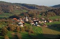
Tihaboj (pronounced [ˈtiːxabɔi̯]; in older sources also Tihoboj[2]) is a nucleated settlement in the local community of Gabrovka, Municipality of Litija, central Slovenia.[3][4] It lies on a terrace in the Gabrovka Hills (Slovene: Gabrovško gričevje),[5][6] a part of the Mirna Valley,[7] along the road connecting Litija and Mirna.[8] The landscape has a fluviokarst character.[9] The settlement comprises the hamlets of Mlake, Orešje, and Psina.[5] The residents mainly live from farming and service activities; many of them drive to work to nearby places.
Name
The name Tihaboj was first attested in 1136 as Tehaboj (other early attestations include Tenchebvo in 1250, Techeloy in 1343, Tethenoy in 1384, Teihawoy in 1436). The medieval inscriptions indicate that the name is derived from *Těxobojь, probably a Slavic personal name derived from *těxa 'consolation' + *bojь 'fight'.[10]
Church
The landmark of the village is the early Baroque church of Saint Mark in the central part of the village, built in the early 17th century, with a late 17th-century octagonal belfry.[11] It belongs to the Parish of the Holy Cross–Gabrovka.
Other cultural heritage
The area of the settlement and the nearby valley of Mlače Creek to the south have been protected as a cultural landscape.[12] On Kostjavc Hill to the northeast, remains of a prehistoric fortification have been excavated, dated to the Hallstattt and the La Tène.[13][14]
Notable people
Notable people that were born or lived in Tihaboj include:
- Diego Barrios Ross,[15] Venezuelan singer and music teacher
- Vid Jerič,[16] Partisan, lieutenant, politician
- Marjeta Mrhar,[17] missionary
References
- ↑ "Tihaboj, Litija". Place Names. Statistical Office of the Republic of Slovenia. Retrieved 21 March 2013.
- ↑ "Razgled po domovini". Domoljub: slovenskemu ljudstvu v poduk in zabavo [Patriot: Instruction and Fun for the Slovene People (in Slovenian). 21 (21). 21 May 1908. p. 326. ISSN 1580-7886.
- ↑ Topole, Maja (1998). "Naselja, poselitev, parcelacije in tip hiše" [Settlements, Population, Parcelation and the House Type]. Mirnska dolina: regionalna geografija porečja Mirne na Dolenjskem [Mirna Valley: The Regional Geography of the Mirna Basin in the Lower Carniola] (in Slovenian). Znanstvenoraziskovalni center Slovenske akademije znanosti in umetnosti. p. 143. ISBN 961-6182-64-1.
- ↑ "Krajevne skupnosti" [Local Communities]. Spletni portal Občine Litija [Web Portal of the Municipality of Litija] (in Slovenian). Retrieved 29 February 2012.
- 1 2 "Tihaboj". Krajevni leksikon Dravske banovine [Lexicon of Place Names of the Drava Banovina] (in Slovenian). Administration of Lexicon of Place Names of the Drava Banovina. 1937. p. 879. COBISS 17618945
- ↑ Topole, Maja (1998). Mirnska dolina: regionalna geografija porečja Mirne na Dolenjskem [Mirna Valley: The Regional Geography of the Mirna Basin in the Lower Carniola] (in Slovenian). Scientific Research Centre, Slovenian Academy of Sciences and Arts. p. 16. ISBN 961-6182-64-1.
- ↑ Topole, Maja (1998). Mirnska dolina: regionalna geografija porečja Mirne na Dolenjskem [Mirna Valley: The Regional Geography of the Mirna Basin in the Lower Carniola] (in Slovenian). Scientific Research Centre, Slovenian Academy of Sciences and Arts. p. 146. ISBN 961-6182-64-1.
- ↑ "Dolgoročni razvojni program občine Litija za obdobje 2007-2015" (in Slovenian). Občina Litija. May 2007.
- ↑ Topole, Maja (1998). Mirnska dolina: regionalna geografija porečja Mirne na Dolenjskem [Mirna Valley: The Regional Geography of the Mirna Basin in the Lower Carniola] (in Slovenian). Scientific Research Centre, Slovenian Academy of Sciences and Arts. p. 13. ISBN 961-6182-64-1.
- ↑ Snoj, Marko. 2009. Etimološki slovar slovenskih zemljepisnih imen. Ljubljana: Modrijan and Založba ZRC, p. 427.
- ↑ "2392: Tihaboj - Cerkev sv. Marka" [2392: Tihaboj – St. Mark's church]. Register nepremične kulturne dediščine [Registry of Immovable Cultural Heritage] (in Slovenian). Ministry of Culture, Republic of Slovenia. Retrieved 29 February 2012.
- ↑ "23958: Tihaboj - Kulturna krajina Mlaškega potoka" [23958: Tihaboj – The Cultural Landscape of Mlače Creek]. Register nepremične kulturne dediščine [Registry of Immovable Cultural Heritage] (in Slovenian). Ministrstvo za kulturo Republike Slovenije. Retrieved 29 February 2012.
- ↑ "24134: Tihaboj - Arheološko najdišče Kostjavc in Gradišče" [24134: Tihaboj – The Archaeologic Site Kostjavc and Gradišče]. Register nepremične kulturne dediščine [Registry of Immovable Cultural Heritage] (in Slovenian). Ministry of Culture, Republic of Slovenia. Retrieved 29 February 2012.
- ↑ Tecco Hvala, Sneža (2003). "Prazgodovinska višinska naselja v okolici Dol pri Litiji" [Prehistoric High-Elevation Settlement in the Vicinity of Dole near Litija] (PDF). Arheološki vestnik (in Slovenian and German). 54: 180–189. ISSN 0570-8966. COBISS 21681709.
- ↑ "Jubilej za Diega Barriosa Rossa". Obrazi. 19. julij 2009. Check date values in:
|date=(help) - ↑ Ferenc, Tone., ed. (2003). Zbor odposlancev slovenskega naroda v Kočevju, 1.-4.10.1943. Dokumenti. Občina Kočevje.
- ↑ "Misijonarka s. Marjeta Mrhar". Usmiljenke.si. Društvo VRNET. 3 March 2011. Retrieved 29. februarja 2012. Check date values in:
|access-date=(help)
External links
| Wikimedia Commons has media related to Tihaboj. |
