Tieke Kāinga
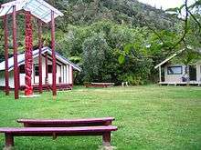
Tieke Kāinga is a small Māori community in New Zealand, on the middle reaches of the Whanganui River 2.5 kilometres (1.6 mi) downstream from the mouth of the Mangatiti Stream. It is centred on Tieke Marae, a converted Department of Conservation tramping hut. The surrounding land is subject to a Māori land claim which began with occupation of the hut in 1993.
History
Pre-European and early 20th Century
Prior to European colonisation, Tieke was a trading centre on the Whanganui River as well as a place of learning and a fortified pā. In 1841 Tieke was described by Wakefield as a large settlement (perhaps 80–90 inhabitants); in the 1840s it shifted across the river and changed its name to Te Ririatepo, but by 1851 it had shifted back and was known as Okirihau, with a population of 93.[1] The area was part of the government's 1886 Waimarino Purchase intended to allow sale of land to settlers, and the chief Te Rangihuatau who lived at Tieke assisted with the purchase. However, there was confusion over whether Tieke itself was included.[2] Te Rangihuatau considered it to be Māori land, the government considered it “Crown Lands which the Natives are allowed to use and occupy without a title”.[3] Early in the 20th century the land changed from tribal to government ownership, although no official records of the 1906 Whanganui River Trust transaction exist today. In 1908 Te Rangihuatau died and the marae was abandoned.[4]
Recent land claim and occupation
The land surrounding Tieke became scenic reserve, and then part of the Whanganui National Park when it was created in 1986. As part of the series of facilities they provided along the river, the Department of Conservation built a large hut at Tieke.[4] In the mid-1990s the Department of Conservation began levying a Facilities Use Pass, a toll on river users to maintain its huts and services, which caused controversy amongst some local Māori.[2] In September 1993 a group called Te Whānau o Tieke Māori reclaimed the land, occupying the hut and converting it into a marae.[5]
Current inhabitants
Today Tieke Kāinga is home to an extended family, Te Whānau o Tieke, also known as Tamahaki after the name of their common ancestor, whose members trace their ancestry to pre-European Tieke.[2] They claim membership of the iwi Ngā Rauru.[6] However, the marae also serves as a popular stop-off point for tourists canoeing the Whanganui River (part of the Whanganui Journey). Another camping site, Ramanui, sits nearby on the opposite bank of the river.
Whilst the land is still formally disputed, the Department of Conservation and the Te Whānau o Tieke Māori have developed an amicable and co-operative relationship, working together to upgrade and maintain facilities at Tieke Kāinga.[7]
References
- ↑ Walton, A. (1994). "Settlement Patterns in the Whanganui River Valley, 1839–1864" (PDF). New Zealand Journal of Archaeology. 16: 123–168.
- 1 2 3 Levine, Hal (July 2011). "Visiting Tieke Kāinga: the Authenticity of a Maori Welcome". Oceania. 81 (2): 137–147. Retrieved 2 December 2015. – via EBSCO's Academic Search Complete (subscription required)
- ↑ "Wai 903: He Whiritaunoka: The Whanganui Land Report". Waitangi Tribunal. 2015. Retrieved 2 December 2015.
- 1 2 Parnell, Jim. (2005) Tieke. Whanganui RIver. Retrieved April 9, 2007
- ↑ Young, David. (22 September 2012). 'Whanganui tribes - The 20th century' Te Ara - Encyclopedia of New Zealand. Retrieved 3 Dec 2015
- ↑ Yarwood, Vaughan (July–September 1999). "The Family at Tieke". New Zealand Geographic (043): 112–143. Retrieved 2 December 2015.
- ↑ "Marae stay appeals to Whanganui river tourists". Radio New Zealand. Retrieved 2015-12-03.
Coordinates: 39°20′15″S 174°59′35″E / 39.33750°S 174.99306°E