Tibetan Plateau
| Tibetan Plateau | |
|---|---|
| 青藏高原, Qīngzàng Gāoyuán | |
 The Tibetan Plateau lies between the Himalayan range to the south and the Taklamakan Desert to the north. | |
| Dimensions | |
| Length | 2,500 km (1,600 mi) |
| Width | 1,000 km (620 mi) |
| Area | 2,500,000 km2 (970,000 sq mi) |
| Geography | |
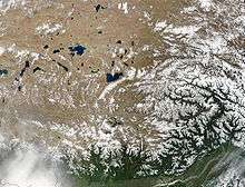
 Tibetan Plateau and surrounding areas above 1600 m | |
| Location | Tibet, China |
| Range coordinates | 33°N 88°E / 33°N 88°ECoordinates: 33°N 88°E / 33°N 88°E |
The Tibetan Plateau (Tibetan: བོད་ས་མཐོ།, Wylie: bod sa mtho ), also known in China as the Qinghai–Tibet Plateau or the Qingzang Plateau (Chinese: 青藏高原; pinyin: Qīngzàng Gāoyuán) or Himalayan Plateau, is a vast elevated plateau in Central Asia[1][2][3][4] and East Asia,[5][6][7][8] covering most of the Tibet Autonomous Region and Qinghai Province in western China, as well as part of Ladakh in Jammu and Kashmir state of India. It stretches approximately 1,000 kilometres (620 mi) north to south and 2,500 kilometres (1,600 mi) east to west. With an average elevation exceeding 4,500 metres (14,800 ft), the Tibetan Plateau is sometimes called "the Roof of the World" and is the world's highest and largest plateau, with an area of 2,500,000 square kilometres (970,000 sq mi) (about five times the size of Metropolitan France).[9] Sometimes termed the Third Pole, the Tibetan Plateau contains the headwaters of the drainage basins of most of the streams in surrounding regions. Its tens of thousands of glaciers and other geographical and ecological features serve as a "water tower" storing water and maintaining flow. The impact of global warming on the Tibetan Plateau is of intense scientific interest.[10][11][12][13]
Description
The Tibetan Plateau is surrounded by massive mountain ranges.[14] The plateau is bordered to the south by the inner Himalayan range, to the north by the Kunlun Range which separates it from the Tarim Basin, and to the northeast by the Qilian Range which separates the plateau from the Hexi Corridor and Gobi Desert. To the east and southeast the plateau gives way to the forested gorge and ridge geography of the mountainous headwaters of the Salween, Mekong, and Yangtze rivers in northwest Yunnan and western Sichuan (the Hengduan Mountains). In the west the curve of the rugged Karakoram range of northern Kashmir embraces the plateau. The Indus River originates in the western Tibetan Plateau in the vicinity of Lake Mansarovar.

The Tibetan Plateau is bounded in the north by a broad escarpment where the altitude drops from around 5,000 metres (16,000 ft) to 1,500 metres (4,900 ft) over a horizontal distance of less than 150 kilometres (93 mi). Along the escarpment is a range of mountains. In the west the Kunlun Mountains separate the plateau from the Tarim Basin. About halfway across the Tarim the bounding range becomes the Altyn-Tagh and the Kunluns, by convention, continue somewhat to the south. In the 'V' formed by this split is the western part of the Qaidam Basin. The Altyn-Tagh ends near the Dangjin pass on the Dunhuang-Golmud road. To the west are short ranges called the Danghe, Yema, Shule, and Tulai Nanshans. The easternmost range is the Qilian Mountains. The line of mountains continues east of the plateau as the Qin Mountains which separate the Ordos Region from Sichuan. North of the mountains runs the Gansu or Hexi Corridor which was the main silk-road route from China proper to the West.
The plateau is a high-altitude arid steppe interspersed with mountain ranges and large brackish lakes. Annual precipitation ranges from 100 to 300 millimetres (3.9 to 11.8 in) and falls mainly as hail. The southern and eastern edges of the steppe have grasslands which can sustainably support populations of nomadic herdsmen, although frost occurs for six months of the year. Permafrost occurs over extensive parts of the plateau. Proceeding to the north and northwest, the plateau becomes progressively higher, colder and drier, until reaching the remote Changthang region in the northwestern part of the plateau. Here the average altitude exceeds 5,000 metres (16,000 ft) and winter temperatures can drop to −40 °C (−40 °F). As a result of this extremely inhospitable environment, the Changthang region (together with the adjoining Kekexili region) is the least populous region in Asia, and the third least populous area in the world after Antarctica and northern Greenland.
Geology and geological history

The geological history of the Tibetan Plateau is closely related to that of the Himalayan mountain range. The Himalayas are among the youngest mountain ranges on the planet and consist mostly of uplifted sedimentary and metamorphic rock. Their formation is a result of a continental collision or orogeny along the convergent boundary between the Indo-Australian Plate and the Eurasian Plate.
The collision began in the Upper Cretaceous period about 70 million years ago, when the north-moving Indo-Australian Plate, moving at about 15 cm (6 in) per year, collided with the Eurasian Plate. About 50 million years ago, this fast moving Indo-Australian plate had completely closed the Tethys Ocean, the existence of which has been determined by sedimentary rocks settled on the ocean floor, and the volcanoes that fringed its edges. Since these sediments were light, they crumpled into mountain ranges rather than sinking to the floor. The Indo-Australian plate continues to be driven horizontally below the Tibetan plateau, which forces the plateau to move upwards, the plateau is still rising at a rate of approximately 5 mm (0.2 in) per year.
Animal and plant life
Tibet's elevation and lack of precipitation produces an alpine tundra environment, which reduces species diversity. Tibet hosts species of wolf, wild donkey, cranes, vultures, hawks, geese, snakes, and buffalo. One notable animal is the high-altitude jumping spider, that can live at elevations of over 6,500 metres (21,300 ft).[15]
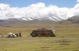
Nomadic culture
Nomads on the Tibetan Plateau and in the Himalayas are the remainders of nomadic practices historically once widespread in Asia and Africa.[16] Pastoral nomads constitute about 40% of the ethnic Tibetan population.[17] The presence of nomadic peoples on the plateau is predicated on their adaptation to survival on the world's grassland by raising livestock rather than crops, which are unsuitable to the terrain. Archaeological evidence suggests that the colonization leading to the full-time occupation of the plateau occurred much later than the previously thought 30,000 years ago.
Impact on other regions
Role in monsoons

Monsoons are caused by the different amplitudes of surface temperature seasonal cycles between land and oceans. This differential warming happens because heating rates differ between land and water. Ocean heating is distributed vertically through a "mixed layer" that may be fifty meters deep through the action of wind and buoyancy-generated turbulence, whereas the land surface conducts heat slowly, with the seasonal signal penetrating only a meter or so. Additionally, the specific heat capacity of liquid water is significantly greater than that of most materials that make up land. Together, these factors mean that the heat capacity of the layer participating in the seasonal cycle is much larger over the oceans than over land, with the consequence that the land warms and cools faster than the ocean. In turn, air over the land warms faster and reaches a higher temperature than does air over the ocean.[18] The warmer air over land tends to rise, creating an area of low pressure. The pressure anomaly then causes a steady wind to blow toward the land, which brings the moist air over the ocean surface with it. Rainfall is then increased by the presence of the moist ocean air. The rainfall is stimulated by a variety of mechanisms, such as low-level air being lifted upwards by mountains, surface heating, convergence at the surface, divergence aloft, or from storm-produced outflows near the surface. When such lifting occurs, the air cools due expansion in lower pressure, which in turn produces condensation and precipitation.
In winter, the land cools off quickly, but the ocean maintains the heat longer. The hot air over the ocean rises, creating a low-pressure area and a breeze from land to ocean while a large area of drying high pressure is formed over the land, increased by wintertime cooling.[18] Monsoons are similar to sea and land breezes, a term usually referring to the localized, diurnal cycle of circulation near coastlines everywhere, but they are much larger in scale, stronger and seasonal.[19] The seasonal monsoon wind shift and weather associated with the heating and cooling of the Tibetan plateau is the strongest such monsoon on Earth.
Glaciology: the Ice Age and at present

Today, Tibet is an important heating surface of the atmosphere. However, during the Last Ice Age a c. 2,400,000 square kilometres (930,000 sq mi) ice sheet covered the plateau.[20][21][22] Due to its great extent, this glaciation in the subtropics was an important element of radiative forcing. With a much lower latitude, the ice in Tibet reflected at least 4 times more radiation energy per unit area into space than ice at higher latitudes. Thus, while the modern plateau heats the overlying atmosphere, during the Last Ice Age it helped to cool it.[23]
This cooling had multiple effects on regional climate. Without the thermal low pressure caused by the heating, there was no monsoon over the Indian subcontinent. This lack of monsoon caused extensive rainfall over the Sahara desert, expansion of the Thar desert, more dust deposited into the Arabian Sea, and a lowering of the biotic life zones on the Indian subcontinent. Animals responded to this shift in climate, with the Javan Rusa deer migrating into India.[24]
In addition, the glaciers in Tibet created meltwater lakes in the Qaidam Basin, the Tarim Basin, and the Gobi Desert, despite the strong evaporation caused by the low latitude. Silt and clay from the glaciers accumulated in these lakes; when the lakes dried at the end of the ice age, the silt and clay were blown by the downslope wind off the Plateau. These airborne fine grains produced the enormous amount of loess in the Chinese lowlands.[24]
Effect of climate change
The Tibetan Plateau contains the world's third-largest store of ice. Qin Dahe, the former head of the China Meteorological Administration, issued the following assessment in 2009:
"Temperatures are rising four times faster than elsewhere in China, and the Tibetan glaciers are retreating at a higher speed than in any other part of the world." "In the short term, this will cause lakes to expand and bring floods and mudflows." "In the long run, the glaciers are vital lifelines for Asian rivers, including the Indus and the Ganges. Once they vanish, water supplies in those regions will be in peril."[25]
See also
Notes
- ↑ Illustrated Atlas of the World (1986) Rand McNally & Company. ISBN 0-528-83190-9 pp. 164-5
- ↑ Atlas of World History (1998 ) HarperCollins. ISBN 0-7230-1025-0 pg. 39
- ↑ "The Tibetan Empire in Central Asia (Christopher Beckwith)". Retrieved 2009-02-19.
- ↑ Hopkirk 1983, pg. 1
- ↑ Peregrine, Peter Neal & Melvin Ember, etc. (2001). Encyclopedia of Prehistory: East Asia and Oceania, Volume 3. Springer. p. 32. ISBN 978-0-306-46257-3.
- ↑ Morris, Neil (2007). North and East Asia. Heinemann-Raintree Library. p. 11. ISBN 978-1-4034-9898-4.
- ↑ Webb, Andrew Alexander Gordon (2007). Contractional and Extensional Tectonics During the India-Asia Collision. ProQuest LLC. p. 137. ISBN 978-0-549-50627-0.
- ↑ Marston, Sallie A. and Paul L. Knox, Diana M. Liverman (2002). World regions in global context: peoples, places, and environments. Prentice Hall. p. 430. ISBN 978-0-13-022484-2.
- ↑ "Natural World: Deserts". National Geographic. Archived from the original on 2006-01-12.
- ↑ Leslie Hook (August 30, 2013). "Tibet: life on the climate front line". The Financial Times. Retrieved September 1, 2013.
- ↑ Liu, Xiaodong; Chen (2000). "Climatic warming in the Tibetan Plateau during recent decades". International Journal of Climatology. 20 (14) – via Academia.edu.
- ↑ Ni, Jian (2000). "A Simulation of Biomes on the Tibetan Plateau and Their Responses to Global Climate Change". Mountain Research and Development. 20 (1). doi:10.1659/0276-4741(2000)020[0080:ASOBOT]2.0.CO;2. Retrieved 26 August 2016 – via BioOne.
- ↑ Cheng, Guodong; Wu (8 June 2007). "Responses of permafrost to climate change and their environmental significance, Qinghai-Tibet Plateau". Journal of Geophysical Research. 112 (F2). doi:10.1029/2006JF000631. Retrieved 26 August 2016 – via Wiley.
- ↑ Yang, Qinye; Zheng, Du (2004). A Unique Geographical Unit. ISBN 9787508506654. Retrieved 2007-08-05.
- ↑ "Wild China: The Tibetan Plateau". The Nature of Things. Canadian Broadcasting Company. Retrieved 2013-03-21.
- ↑ David Miller. "Nomads of Tibet and Bhutan". asinart.com. Retrieved 2008-02-10.
- ↑ In pictures: Tibetan nomads BBC News
- 1 2 Oracle Thinkquest Education Foundation. monsoons: causes of monsoons. Retrieved on 22 May 2008.
- ↑ "The Asian Monsoon". BBC Weather. Archived from the original on 2004-11-01.
- ↑ Kuhle, Matthias (1998). "Reconstruction of the 2.4 Million km2 Late Pleistocene Ice Sheet on the Tibetan Plateau and its Impact on the Global Climate". Quaternary International. 45/46: 71–108. doi:10.1016/S1040-6182(97)00008-6.
- ↑ Kuhle, M (2004). "The High Glacial (Last Ice Age and LGM) ice cover in High and Central Asia". In Ehlers, J.; Gibbard, P.L. Development in Quaternary Science 2c (Quaternary Glaciation - Extent and Chronology, Part III: South America, Asia, Africa, Australia, Antarctica). pp. 175–199.
- ↑ Kuhle, M. (1999). "Tibet and High Asia V. Results of Investigations into High Mountain Geomorphology, Paleo-Glaciology and Climatology of the Pleistocene". GeoJournal. 47 (1–2): 3–276. doi:10.1023/A:1007039510460. See chapter entitled: "Reconstruction of an approximately complete Quaternary Tibetan Inland Glaciation between the Mt. Everest- and Cho Oyu Massifs and the Aksai Chin. - A new glaciogeomorphological southeast-northwest diagonal profile through Tibet and its consequences for the glacial isostasy and Ice Age cycle".
- ↑ Kuhle, M. (1988). "The Pleistocene Glaciation of Tibet and the Onset of Ice Ages- An Autocycle Hypothesis". GeoJournal. 17 (4): 581–596. doi:10.1007/BF00209444. Tibet and High-Asia I. Results of the Sino-German Joint Expeditions (I).
- 1 2 Kuhle, Matthias (2001). "The Tibetan Ice Sheet; its Impact on the Palaeomonsoon and Relation to the Earth's Orbital Variations". Polarforschung. 71 (1/2): 1–13.
- ↑ "Global warming benefits to Tibet: Chinese official". AFP. 2009-08-18.
References
- Hopkirk, Peter (1983). Trespassers on the Roof of the World: The Secret Exploration of Tibet. J. P. Tarcher. ISBN 0-87477-257-5.
- Brantingham, P. J. & Xing, G. (2006). "Peopling of the northern Tibetan Plateau". World Archaeology. 38 (3): 387–414. doi:10.1080/00438240600813301.
External links
| Wikimedia Commons has media related to Tibetan Plateau. |
- ON THINNER ICE 如履薄冰 (by GRIP, Asia Society and MediaStorm)
- The Third Pole: Understanding Asia's Water Crisis
- The End of Earth's Summer
- Long Rivers and Distant Sources
- "Roof of the Earth" Offers Clues About How Our Planet Was Shaped
- Plateau Perspectives (international NGO)
- Leaf morphology and the timing of the rise of the Tibetan Plateau
- Weather in the eastern Chang Tang at the Wayback Machine (archived 19 March 2006)
- Protected areas of the Tibetan Plateau region
- "North Tibetan Plateau-Kunlun Mountains alpine desert". Terrestrial Ecoregions. World Wildlife Fund.
- Photos of Tibetan nomads
- "Roof of the Earth" Offers Clues About How Our Planet Was Shaped
- Contemporary lifestyle and language learning center from Tibet lhasa, the official language of Tibetan. podcast.
Subfields of physical geography | ||
|---|---|---|
 | ||