Thruscross Reservoir
| Thruscross Reservoir | |
|---|---|
 | |
| Location | North Yorkshire |
| Coordinates | 54°1′1″N 1°46′24″W / 54.01694°N 1.77333°WCoordinates: 54°1′1″N 1°46′24″W / 54.01694°N 1.77333°W |
| Type | reservoir |
| Primary inflows | Washburn |
| Primary outflows | Washburn |
| Basin countries | United Kingdom |
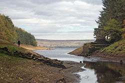
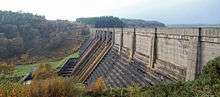
Thruscross Reservoir is the northernmost of four reservoirs in the Washburn valley, lying north of Otley and west of Harrogate in North Yorkshire, England, near the hamlet of Thruscross. It can be found on an unclassified road from the A59 road[1] (where the road from Otley joins.) Permission to construct the reservoir was granted via a water order in 1960[2] and Thruscross was completed in 1966,[3] much later than the other three reservoirs which date back to the nineteenth century.[4]
The construction of the reservoir flooded the village of West End,[5] which was already largely derelict following the decline of the flax industry. There is another hamlet close to the reservoir that retains the name of West End.[6] The remains of a flax mill can be seen at the edge of the reservoir, and more of the village has been revealed at times of drought, such as the summers of 1989 and 1990.[7] The work to build the reservoir included clearing trees, removing sacred items from the church and exhuming bodies from the graveyard.[8][9]
The reservoir is the property of Yorkshire Water, which manages it for the benefit of walkers, anglers and wildlife. Yorkshire Water also release water at specific times on the weekends and in the evenings to allow canoeists to navigate along all four reservoirs in the Washburn Valley. This canoe run starts at Thruscross.[10]
In the novel In a Dry Season by the English-born, Canadian-based crime writer Peter Robinson, the fictional village of Hobb's End, flooded by the creation of the Thornfield Reservoir, is exposed during a drought, leading to the discovery of a body.[11] The geography described by Robinson indicates that he based the location of Hobb's End on the village of West End. The small bridge over the Washburn becomes the 'Fairy Bridge' and the flax mill is mentioned explicitly.
References
- ↑ "Motorists urged to use official diversion route after A59 Kex Gill closure - with further monitoring due on Monday". Craven Herald. 9 January 2016. Retrieved 18 January 2016.
- ↑ "The Discovery Service". discovery.nationalarchives.gov.uk. Retrieved 18 January 2016.
- ↑ Priestley, Mike (8 September 2008). "Thruscross Reservoir". Bradford Telegraph and Argus. Retrieved 18 January 2016.
- ↑ Claydon, J R; Knott, D L; Carter, I C. "The Washburn Valley Reservoirs – spillway improvements" (PDF). British Dams. Yorkshire Water. Retrieved 18 January 2016.
- ↑ "Thruscross Reservoir - North Yorkshire - Walk 1574 - a walk description from Walking Britain". www.walkingbritain.co.uk. Retrieved 18 January 2016.
- ↑ "GENUKI: Fewston Supplementary". www.genuki.org.uk. Retrieved 18 January 2016.
- ↑ "Thruscross Reservoir walk with submerged village". Wharfedale Observer. 14 June 2013. Retrieved 18 January 2016.
- ↑ "Nidderdale AONB" (PDF). Visit Nidderdale. 2014. p. 11. Retrieved 18 January 2016.
- ↑ Berry, Chris (5 April 2014). "Life before the reservoirs retold in picturesque valley". Yorkshire Post. Retrieved 18 January 2016.
- ↑ "Washburn in river works" (PDF). British Canoe Union. BCU. Retrieved 18 January 2016.
- ↑ "Underwater mysteries resurface in podcast". Harrogate Advertiser. 2 August 2007. Retrieved 18 January 2016.
External links
- Yorkshire Water - Thruscross
- Yorkshire Water guide to the area immediately surrounding the reservoir