Thornton, Washington
| Thornton, Washington | |
|---|---|
| Unincorporated community | |
 Thornton, Washington | |
| Coordinates: 47°07′15″N 117°23′23″W / 47.12083°N 117.38972°WCoordinates: 47°07′15″N 117°23′23″W / 47.12083°N 117.38972°W | |
| Country | United States |
| State | Washington |
| County | Whitman |
| Elevation | 2,310 ft (700 m) |
| Time zone | Pacific (PST) (UTC-8) |
| • Summer (DST) | PDT (UTC-7) |
| ZIP code | 99176 |
| Area code(s) | 509 |
| GNIS feature ID | 1509005[1] |
Thornton is an unincorporated community in Whitman County, Washington, United States. Founded in 1889 by P.M. Sheehan,[2] Thornton is located near U.S. Route 195 7 miles (11 km) west of Oakesdale. Thornton has a post office with ZIP code 99176.[3]
References
- ↑ U.S. Geological Survey Geographic Names Information System: Thornton, Washington
- ↑ Majors, Harry M. (1975). Exploring Washington. Van Winkle Publishing Co. p. 112. ISBN 978-0-918664-00-6.
- ↑ ZIP Code Lookup
Municipalities and communities of Whitman County, Washington, United States | ||
|---|---|---|
| Cities | 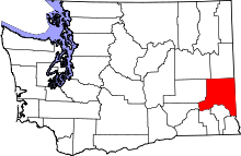 | |
| Towns | ||
| CDP | ||
| Other unincorporated communities | ||
| Ghost towns | ||
This article is issued from Wikipedia - version of the 10/16/2016. The text is available under the Creative Commons Attribution/Share Alike but additional terms may apply for the media files.