Thonotosassa, Florida
| Thonotosassa, Florida | |
|---|---|
| CDP | |
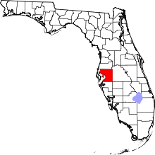
 Location in Hillsborough County and the state of Florida | |
| Coordinates: 28°3′22″N 82°17′34″W / 28.05611°N 82.29278°WCoordinates: 28°3′22″N 82°17′34″W / 28.05611°N 82.29278°W | |
| Country | United States |
| State | Florida |
| County | Hillsborough |
| Area | |
| • Total | 18 sq mi (46.6 km2) |
| • Land | 16.7 sq mi (43.2 km2) |
| • Water | 1.3 sq mi (3.4 km2) |
| Elevation | 33 ft (10 m) |
| Population (2010) | |
| • Total | 13,014 |
| • Density | 338.4/sq mi (130.7/km2) |
| Time zone | Eastern (EST) (UTC-5) |
| • Summer (DST) | EDT (UTC-4) |
| ZIP code | 33592 |
| Area code(s) | 813 |
| FIPS code | 12-71725[1] |
| GNIS feature ID | 0292232[2] |
Thonotosassa is a census-designated place (CDP) in Hillsborough County, Florida, United States. The population was 13,014 at the 2010 census.[3]
History
The name Thonotosassa comes from the Seminole-Creek words thlonto and sasse, meaning the place was a source of valuable flint. Following the establishment of Fort Brooke in 1824 in what is now Tampa, a road that ran northwest of Lake Thonotosassa was built between Fort Brooke and Fort King in Ocala. This road became known as the Fort King Road, which today is crossed in several locations by US Route 301.[4] Nevertheless, the presence of a Seminole village largely discouraged whites from moving into the area. After the Second Seminole War ended in 1842, whites began to settle.
In 1893, the Tampa and Thonotosassa Railroad opened a 13-mile route between the two growing communities.[5] This line today no longer extends into Thonotosassa, its northern tracks having been removed along with the town depot by the 1980s;[6] but its southern portion remains a busy industrial spur, joining with the CSX main line at Neve Wye.
Among other areas for recreation for the youth is the Morris Bridge Road area and its Nature's Classroom.[7]
Geography
Thonotosassa is located at 28°3′22″N 82°17′34″W / 28.05611°N 82.29278°W (28.056135, -82.292663).[8]
According to the United States Census Bureau, the community has a total area of 18.0 square miles (47 km2), of which 16.7 square miles (43 km2) is land and 1.3 square miles (3.4 km2) (7.23%) is water. It is 220 ft above sea level. It is located approximately ten miles from Plant City.
Demographics
| Historical population | |||
|---|---|---|---|
| Census | Pop. | %± | |
| 2000 | 6,091 | — | |
| 2010 | 13,014 | 113.7% | |
| source:[9] | |||
As of the census[1] of 2000, there were 6,091 people, 2,178 households, and 1,616 families residing in the community. The population density was 365.5 people per square mile (141.1/km²). There were 2,532 housing units at an average density of 151.9/sq mi (58.6/km²). The racial makeup of the community was 90.63% White, 4.94% African American, 0.51% Native American, 0.38% Asian, 0.03% Pacific Islander, 1.79% from other races, and 1.72% from two or more races. Hispanic or Latino of any race were 6.29% of the population.
There were 2,178 households out of which 34.9% had children under the age of 18 living with them, 55.6% were married couples living together, 12.2% had a female householder with no husband present, and 25.8% were non-families. 20.1% of all households were made up of individuals and 8.1% had someone living alone who was 65 years of age or older. The average household size was 2.72 and the average family size was 3.07.
In the community the population was spread out with 26.7% under the age of 18, 7.6% from 18 to 24, 28.6% from 25 to 44, 23.1% from 45 to 64, and 14.0% who were 65 years of age or older. The median age was 37 years. For every 100 females there were 99.6 males. For every 100 females age 18 and over, there were 95.4 males.
The median income for a household in the community was $43,159, and the median income for a family was $44,829. Males had a median income of $31,914 versus $22,674 for females. The per capita income for the community was $18,191. About 12.7% of families and 16.0% of the population were below the poverty line, including 23.2% of those under age 18 and 17.4% of those age 65 or over.
References
- 1 2 "American FactFinder". United States Census Bureau. Retrieved 2008-01-31.
- ↑ "US Board on Geographic Names". United States Geological Survey. 2007-10-25. Retrieved 2008-01-31.
- ↑ Florida Trend Report 2: State and Complete Places (Sub-state 2010 Census Data). Missouri Census Data Center. Accessed 2011-04-07.
- ↑ "History of Pasco County - Fort King Road". fivay.org. Retrieved 2016-09-15.
- ↑ Turner, G.: "A Short History of Florida Railroads", page 65. Arcadia Publishing, 2003.
- ↑ Mulligan, M.: "Railroad Depots of Central Florida", page 53. Arcadia Publishing, 2008.
- ↑
- ↑ "US Gazetteer files: 2010, 2000, and 1990". United States Census Bureau. 2011-02-12. Retrieved 2011-04-23.
- ↑ "Census of Population and Housing". U.S. Census Bureau. Retrieved 2013-01-21.
External links
Thonotosassa at DMOZ