Thonne-la-Long
| Thonne-la-Long | |
|---|---|
|
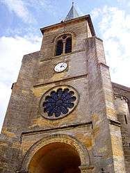
The church | |
 Thonne-la-Long | |
|
Location within Grand Est region  Thonne-la-Long | |
| Coordinates: 49°33′44″N 5°25′35″E / 49.5622°N 5.4264°E / 49.5622; 5.4264Coordinates: 49°33′44″N 5°25′35″E / 49.5622°N 5.4264°E / 49.5622; 5.4264 | |
| Country | France |
| Region | Grand Est |
| Department | Meuse |
| Arrondissement | Verdun |
| Canton | Montmédy |
| Intercommunality | Communauté de communes du pays de Montmédy |
| Government | |
| • Mayor (2008–2014) | Thierry Leclere |
| Area1 | 9.5 km2 (3.7 sq mi) |
| Population (1999)2 | 181 |
| • Density | 19/km2 (49/sq mi) |
| Time zone | CET (UTC+1) |
| • Summer (DST) | CEST (UTC+2) |
| INSEE/Postal code | 55508 / 55600 |
| Elevation |
207–349 m (679–1,145 ft) (avg. 211 m or 692 ft) |
|
1 French Land Register data, which excludes lakes, ponds, glaciers > 1 km² (0.386 sq mi or 247 acres) and river estuaries. 2 Population without double counting: residents of multiple communes (e.g., students and military personnel) only counted once. | |
Thonne-la-Long is a commune in the Meuse department in Grand Est in north-eastern France.
See also
| Wikimedia Commons has media related to Thonne-la-Long. |
This article is issued from Wikipedia - version of the 11/6/2016. The text is available under the Creative Commons Attribution/Share Alike but additional terms may apply for the media files.