Thirlmere
| Thirlmere | |
|---|---|
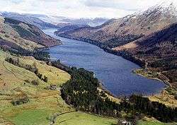 Seen from Steel Fell at the southern end of the lake | |
| Location | Lake District National Park, Cumbria, England |
| Coordinates | 54°32′N 3°04′W / 54.533°N 3.067°WCoordinates: 54°32′N 3°04′W / 54.533°N 3.067°W |
| Lake type | Reservoir |
| Primary inflows | Launchy Gill, Dob Gill, Wyth Burn, Birkside Gill |
| Primary outflows | St John's Beck |
| Basin countries | England |
| Max. length | 6.05 km (3.76 mi) |
| Max. width | 0.178 km (0.111 mi) |
| Surface area | 3.25 km2 (1.25 sq mi) |
| Max. depth | 40 metres (131 ft) |
| Shore length1 | 15 km (9.3 mi) |
| Surface elevation | 178 m (584 ft) |
| Islands | 2 |
| 1 Shore length is not a well-defined measure. | |
Thirlmere is a reservoir in the Borough of Allerdale in Cumbria and the English Lake District. It runs roughly south to north, with a dam at the northern end, and is bordered on the eastern side by the A591 road and on the western side by a minor road.
Thirlmere was constructed in the 19th century by the Manchester Corporation to provide the burgeoning industrial city of Manchester with water supplies. The 96 mile-long Thirlmere Aqueduct still provides water to the Manchester area.
History


Before the construction of the reservoir the glacial valley was occupied by two smaller lakes,[1] although various maps show only one, known by various names including Leathes Water,[2] Wythburn Water[3] Thirle Water,[4] and Thirlmere.[5] The growth of the industrial city of Manchester during the 19th century had led to an increased demand for water. The water level in the valley was raised by construction of a dam by Manchester Corporation Waterworks at the northern end of Thirlmere, in 1890–1894. The reservoir supplied water to Manchester via the Thirlmere Aqueduct which is 95.9-mile (154.3 km). John Frederick Bateman was advisor to the corporation for both projects.
The creation of the reservoir flooded the village of Wythburn and the hamlet of Armboth,[6] with the loss of a school, vicarage, inns, farms and houses. Only the hamlet of Steel End (at the south end of the present Thirlmere) and Wythburn Church (above the reservoir on the east) remained. New housing was created at Fisher End and Stanah. east of the northern end of the reservoir.[1]
There was strong local opposition to the construction of the lake and the Thirlmere Defence Association (TDA) was formed to oppose the parliamentary act which was required before work could begin. The TDA opposed on the basis that raising the water level by 50 feet would submerge the dramatic cliffs which then surrounded the lake and a receding shoreline in summer would expose the smelly and unsightly lake bed. The organisation managed to stall the Bill in Parliament in 1878, but the Act was passed in 1879.[7]
Etymology
" ...Leathes-Water' called also 'Thirlmere' or 'Wythburn-water' 1769...Probably 'the lake with/at the narrowing' from OE þyrel 'aperture', pierced hole' plus OE mere 'lake'. The lake had an especially narrow 'waist', spanned by a causeway and bridges",[8] before the dam was built. (OE = Old English.)
Geography
The name is sometimes also applied to the whole valley, which connects Grasmere in the south with the Vale of Keswick in the north. The highest point in the valley is Dunmail Raise. The A591 runs the length of the valley and goes over Dunmail Raise.
The Helvellyn ridge lies to the east of Thirlmere. To the west of Thirlmere are a number of fells; for instance, Armboth Fell and Raven Crag both of which give views of the lake.
Management
The reservoir and surrounding forested valley is owned and managed by United Utilities, a private water and waste water company.
Accidental death
On 24 July 2013 three people got into distress at the reservoir. A 28-year-old man from Pakistan died while swimming with a group of family and friends.[9] The man's sister also got into difficulties but survived after being given CPR at the scene.
Further reading
- Ritvo, Harriet. The Dawn of Green: Manchester, Thirlmere, and Modern Environmentalism. Chicago: The University of Chicago Press, 2009, ISBN 978-0-226-72082-1.
References
| Wikimedia Commons has media related to Thirlmere. |
- 1 2 "Genneral introduction: Recent changes". St John's, Castlerigg and Wythburn Parish Plan (PDF). 2004. p. 3. Retrieved 8 May 2016.
- ↑ Cooke, George (1802). Maps, Westmoreland, Cumberland, etc.
- ↑ Ogilby (1675). "Plate 96". Road Book, Britannia. Retrieved 7 May 2016.
- ↑ Ford, William (1839). Map of the Lake District, published in A Description of Scenery in the Lake District,. Retrieved 7 May 2016.
- ↑ Otley, Jonathan (1818). New Map of the District of the Lakes, in Westmorland, Cumberland, and Lancashire.
- ↑ "Wythburn". Towns and villages of Cumbria. Cumbria Directory. Retrieved 7 May 2016.
- ↑ Ritvo, Harriet (6 June 2003), "Fighting for Thirlmere--The Roots of Environmentalism", Science, 300 (5625): 1510–11, doi:10.1126/science.1079920, PMID 12791968
- ↑ Whaley, Diana (2006). A dictionary of Lake District place-names. Nottingham: English Place-Name Society. pp. lx,423 p.338. ISBN 0904889726.
- ↑ "Thirlmere death: Man named as Muhammad Bilal Bhaty : Timeline". BBC News. 2013-07-24. Retrieved 2013-07-24.