Thimlich Ohinga
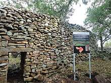
Thimlich Ohinga is complex of stone-built ruins in Migori county, Western Kenya, in East Africa.[1] It is one of 138 sites containing 521 stone structures that were built around the Lake Victoria region in Kenya. The main enclosure of Thimlich Ohinga has walls that vary from 1.0 to 3 meters in thickness, and 1 to 4.2 meters in height.[2] The structures were built from undressed blocks, rocks, and stonesset in place without mortar.[2] The densely packed stones interlock. The site is believed to be more than 550 years old.[3] The area is occupied the Luo people. 'Thimlich' means "frightening dense forest" in Dholuo, the language of the Luo.[2][3] 'Ohinga' plural 'Ohingni' means "a large fortress" in (Dholuo)
Inhabitants and architectural style
A people who spoke a Bantu language possibly proto-Luhya/ Gusii inhabited the area for a time before they mysteriously vacated sometime right before, during or after the expansion of the Luo into the area. The Kisii (who live near Thimlich Ohinga) and the Maragoli, Bunyore (two branches of the Luhya people) descend from three men called Gusii, Mulogoli and Anyore respectively. These three men were the sons of a man called Andimi. The Maragoli, Kisii and BaNyore people settled this part of South-West Kenya sometime in the 13th or 14th century before the arrival of the Luo people 300 years ago.[2] After the expansion of the Luo into the area, who were more numerous at the time, the three ethnicities formally split into three, with the Kisii heading south and the Maragoli (or Valogooli/ Balogooli) and the Banyore (or Vanyole) heading back north.
Migrants from Uganda, Rwanda, Sudan, and Burundi are believed to have also made their way through the area, some of whom ended up going south into Tanzania. It was vacated for the last time during the first half of the twentieth century.[4]
The architectural style of the Thimlich Ohinga mirrors the building style of the Great Zimbabwe Empire, 1,900 miles / 3,600 kilometres to the south in Zimbabwe, albeit smaller in size. Another difference is that Great Zimbabwe architecture was built with shaped stones, however, like Thimlich Ohinga, the utility of mortar appears to have been avoided. Thimlich Ohinga is an example of defensive savanna architecture, which eventually became a traditional style in various parts of East and Southern Africa. It portrays stone-built homesteads practices and a communal, centralized system of control, which became prevalent in the Lake Victoria region. Later forms of this stone-walled architecture can be seen on some traditional houses in Western and South-Western Kenya.[5]
Oral histories suggest that Thimlich Ohinga was constructed by the then-inhabitants to serve as protection against outsiders in Kadem, Kanyamwa areas, as well as from neighbouring ethnic groups from what is now Tanzania - but as the names suggest, (Kadem is an example of a Luo name) the present names came about after the Luo began to inhabit the area. For reasons yet unknown, Thimlich Ohinga was abandoned by the original builders. Over time, other communities moved into the area in the period between the 15th and the 19th centuries and those who lived within the complexes maintained them by repairing and modifying the structures. The re-occupation and repair did not interfere with the preservation of the structures. Aside from being a defensive fort, Thimlich Ohinga was also an economic, religious, and social hub. Archaeological research carried by the National Museums of Kenya has unveiled the manufacture of goods like pottery, and also yielded human and animal bones.
Inside the structures, are partitions of various kinds like corridors, smaller enclosures and depressions. Some of the compartments include games sections where men played games like ‘ajua,' and grinding stones where women ground grain. Livestock pens for cattle, sheep, goats, chicken, ducks, guinea fowl and retaining walls for gardens were also built.
The entryways were purposefully made small, so that potential intruders would be quickly subdued by guards in a watch tower near the entrance. It is easy to scan the whole complex from the watchtower built from raised rocks.[2]
Inhabitants of Thimlich Ohinga also had smaller side forts which had houses, meal areas, animal pens, and a granary.[6]
Etymology
Neville Chittick, the former Director of the British Institute of History and Archaeology in East Africa, documented the site in the 1960s. Researchers from the National Museums of Kenya commenced work on the site in 1980. Once called “Liare Valley” after a valley to the north-east of the area, Thimlich Ohinga was gazetted as a Kenyan National Monument under its new name in 1981. The name was changed because 'Liare Valley' did not describe the exact location of the site.
Location
Thimlich Ohinga is located 181 kilometres south of Kisumu in Migori county, on a gentle sloping hill 46 kilometres north-west of Migori town near Macalder's Mines. The other 137 sites that resemble it are concentrated in the areas of Karungu, Kadem-Kanyamkago, Gwassi, Kaksingiri Lake headlands, Kanyidoto and Kanyamwa.[7]
Conservation
The Kenya Wildlife Service, and the National Museums of Kenya have designated Thimlich Ohinga a conservation site. Wild animals like guinea fowl, various species of monkeys, birds and antelope live in the forests surrounding the site. The National Museums of Kenya submitted a request to UNESCO, on behalf of the government, requesting the inclusion of Thimlich Ohinga Cultural Landscape on the World Heritage Site.[7]
References
- ↑ "Thim Lich Ohinga, the 500-year-old Archeological Wonder.". YouTube. 2010-12-24. Retrieved 2014-05-17.
- 1 2 3 4 5 The Mystery of Thimlich Ohinga Fort on Lake Victoria, 2011-03-16, The Star
- 1 2 "National Museums of Kenya - Thimlich Ohinga". Museums.or.ke. Retrieved 2014-05-17.
- ↑ "Thimlich stone wall stands as a living world heritage - Magazine". www.theeastafrican.co.ke. Retrieved 2014-05-17.
- ↑ "THIMLICH OHINGA CULTURAL LANDSCAPE | World Monuments Fund". Wmf.org. Retrieved 2014-05-17.
- ↑ "The Mystery of Thimlich Ohinga Fort on Lake Victoria". The Star. 2011-03-16. Retrieved 2014-05-17.
- 1 2 UNESCO World Heritage Centre (2013-01-07). "The Thimlich Ohinga Cultural Landscape - UNESCO World Heritage Centre". Whc.unesco.org. Retrieved 2014-05-17.
External links
Coordinates: 0°58′23″S 34°15′30″E / 0.9731°S 34.2583°E