Thermopolis, Wyoming
| Thermopolis, Wyoming | |
|---|---|
| Town | |
|
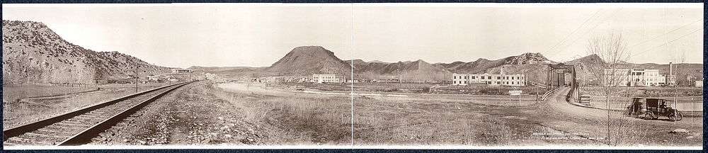
Thermopolis viewed from Roundtop Mountain | |
| Nickname(s): "Thermop" "T-Town" | |
| Motto: "A Past To Behold A Future To Uphold" | |
 Thermopolis, Wyoming Location in the United States | |
| Coordinates: 43°38′44″N 108°12′53″W / 43.64556°N 108.21472°WCoordinates: 43°38′44″N 108°12′53″W / 43.64556°N 108.21472°W | |
| Country | United States |
| State | Wyoming |
| County | Hot Springs |
| Government | |
| • Mayor | Michael "Mike" Mortimore |
| • Assistant to the Mayor | Fred Crosby |
| Area[1] | |
| • Total | 2.47 sq mi (6.40 km2) |
| • Land | 2.38 sq mi (6.16 km2) |
| • Water | 0.09 sq mi (0.23 km2) |
| Elevation~±500 feet | 4,331 ft (1,320 m) |
| Population (2010)[2] | |
| • Total | 3,009 |
| • Estimate (2012[3]) | 3,019 |
| • Density | 1,264.3/sq mi (488.1/km2) |
| Time zone | Mountain (MST) (UTC-7) |
| • Summer (DST) | MDT (UTC-6) |
| ZIP code | 82443 |
| Area code(s) | 307 |
| FIPS code | 56-76515[4] |
| GNIS feature ID | 1597651[5] |
| Website |
www |

Thermopolis is the largest town in, and the county seat of Hot Springs County, Wyoming, United States.[6] As of the 2010 census, the town population was 3,009.
History
"Thermopolis" (/θɜːrˈmɒpəlɪs/) is from the Greek for "Hot City". It is home to numerous natural hot springs, in which mineral-laden waters are heated by geothermal processes. The town is named for the hot springs located there.[7]
The town claims the world's largest mineral hot spring as part of Hot Springs State Park. The springs are open to the public for free as part of an 1896 treaty signed with the Shoshone and Arapaho Indian tribes.
Thermopolis is also the home of the Wyoming Dinosaur Center, which hosts the only Archaeopteryx fossil outside of Europe.
Decline in mineral spring flow
In 1991, the Associated Press reported, in an article entitled "Hot Springs Rationed: Natural Wonder Drying Up:"
| “ | One of Wyoming's natural wonders--massive travertine terraces formed over the centuries by cascading hot mineral water at Hot Springs State Park--appears to be dying.
A dramatic decline in the flow of the main spring that feeds the terraces has prompted park management to maintain the water flow to the park's recreation pools and cut off water to half the terraces. The Big Spring, which pumped 13 million gallons a day in 1896 when the Indians sold the area to the government, now produces mere 3.5 million gallons per day, according to park superintendent Allen Cowardin. Neither Cowardin nor state water experts know what has caused the reduced flow, nor when it dropped so dramatically...[8] |
” |
Geography
Thermopolis is located near the northern end of the Wind River Canyon and Wedding of the Waters, where the north-flowing Wind River becomes the Bighorn River. Thermopolis is ringed by mountains, with the Bridger Mountains to the southeast, the Owl Creek Mountains to the southwest, the Big Horn Mountains to the northeast and the Absaroka Range to the northwest. Thermopolis is the southern-most municipality in the Big Horn Basin.
Roundtop Mountain, on the northern edge of town, is a unique geological formation shaped much like a volcano. It sits at approximately 6,000 feet and is the highest area in the immediate vicinity of Thermopolis.[9]
A large body of water, Boysen Reservoir, lies approximately 17 miles south of Thermopolis and is inhabited by many native species of fish including rainbow, cutthroat and brown trout, walleye, perch and northern pike among others.
According to the United States Census Bureau, the town has a total area of 2.47 square miles (6.40 km2), of which, 2.38 square miles (6.16 km2) of it is land and 0.09 square miles (0.23 km2) is water.[1]
Climate
Thermopolis experiences a semi-arid climate (Köppen BSk) with cold, dry winters and hot, dry summers. In fact, the town features Wyoming's highest average daytime temperatures in July and August.
| Climate data for Thermopolis, Wyoming (1981–2010 normals) | |||||||||||||
|---|---|---|---|---|---|---|---|---|---|---|---|---|---|
| Month | Jan | Feb | Mar | Apr | May | Jun | Jul | Aug | Sep | Oct | Nov | Dec | Year |
| Record high °F (°C) | 67 (19) |
70 (21) |
80 (27) |
90 (32) |
98 (37) |
105 (41) |
107 (42) |
106 (41) |
99 (37) |
92 (33) |
77 (25) |
78 (26) |
107 (42) |
| Average high °F (°C) | 40.5 (4.7) |
45.9 (7.7) |
55.3 (12.9) |
65.2 (18.4) |
74.4 (23.6) |
84.3 (29.1) |
93.3 (34.1) |
91.5 (33.1) |
80.9 (27.2) |
65.2 (18.4) |
51.0 (10.6) |
38.9 (3.8) |
65.53 (18.63) |
| Average low °F (°C) | 11.5 (−11.4) |
16.1 (−8.8) |
25.2 (−3.8) |
33.5 (0.8) |
42.4 (5.8) |
50.2 (10.1) |
57.0 (13.9) |
55.0 (12.8) |
45.0 (7.2) |
33.8 (1) |
21.5 (−5.8) |
11.1 (−11.6) |
33.53 (0.85) |
| Record low °F (°C) | −44 (−42) |
−42 (−41) |
−28 (−33) |
−18 (−28) |
12 (−11) |
24 (−4) |
34 (1) |
23 (−5) |
7 (−14) |
−16 (−27) |
−28 (−33) |
−38 (−39) |
−44 (−42) |
| Average precipitation inches (mm) | 0.41 (10.4) |
0.39 (9.9) |
0.88 (22.4) |
1.61 (40.9) |
2.25 (57.2) |
1.49 (37.8) |
0.98 (24.9) |
0.55 (14) |
1.10 (27.9) |
1.35 (34.3) |
0.64 (16.3) |
0.38 (9.7) |
12.04 (305.8) |
| Average snowfall inches (cm) | 5.4 (13.7) |
4.7 (11.9) |
5.1 (13) |
2.2 (5.6) |
.3 (0.8) |
0 (0) |
0 (0) |
0 (0) |
.2 (0.5) |
2.3 (5.8) |
3.5 (8.9) |
5.0 (12.7) |
28.7 (72.9) |
| Average precipitation days (≥ 0.01 in) | 3.3 | 3.3 | 4.4 | 6.8 | 7.9 | 8.3 | 5.9 | 4.7 | 5.7 | 5.1 | 3.8 | 3.4 | 62.4 |
| Average snowy days (≥ 0.1 in) | 2.4 | 2.1 | 1.8 | .9 | .1 | 0 | 0 | 0 | 0 | .6 | 1.7 | 2.4 | 12.1 |
| Source: NOAA (extremes 1899–present)[10] | |||||||||||||
Demographics
| Historical population | |||
|---|---|---|---|
| Census | Pop. | %± | |
| 1900 | 299 | — | |
| 1910 | 1,524 | 409.7% | |
| 1920 | 2,005 | 31.6% | |
| 1930 | 2,129 | 6.2% | |
| 1940 | 2,422 | 13.8% | |
| 1950 | 2,870 | 18.5% | |
| 1960 | 3,955 | 37.8% | |
| 1970 | 3,063 | −22.6% | |
| 1980 | 3,852 | 25.8% | |
| 1990 | 3,247 | −15.7% | |
| 2000 | 3,172 | −2.3% | |
| 2010 | 3,009 | −5.1% | |
| Est. 2015 | 2,974 | [11] | −1.2% |
2010 census
As of the census[2] of 2010, there were 3,009 people, 1,389 households, and 818 families residing in the town. The population density was 1,264.3 inhabitants per square mile (488.1/km2). There were 1,583 housing units at an average density of 665.1 per square mile (256.8/km2). The racial makeup of the town was 96.4% White, 0.3% African American, 0.9% Native American, 0.5% Asian, 0.4% from other races, and 1.5% from two or more races. Hispanic or Latino of any race were 2.2% of the population.
There were 1,389 households of which 24.0% had children under the age of 18 living with them, 44.3% were married couples living together, 10.4% had a female householder with no husband present, 4.1% had a male householder with no wife present, and 41.1% were non-families. 35.8% of all households were made up of individuals and 14.8% had someone living alone who was 65 years of age or older. The average household size was 2.11 and the average family size was 2.70.
The median age in the town was 47 years. 20.1% of residents were under the age of 18; 7.2% were between the ages of 18 and 24; 20.2% were from 25 to 44; 30.5% were from 45 to 64; and 22.1% were 65 years of age or older. The gender makeup of the town was 49.1% male and 50.9% female.
2000 census
As of the census[4] of 2000, there were 3,172 people, 1,342 households, and 849 families residing in the town. The population density was 1,331.0 people per square mile (514.6/km2). There were 1,568 housing units at an average density of 657.9 per square mile (254.4/km2). The racial makeup of the town was 95.90% White, 0.47% African American, 1.70% Native American, 0.25% Asian, 0.50% from other races, and 1.17% from two or more races. Hispanic or Latino of any race were 2.30% of the population.
There were 1,342 households out of which 26.8% had children under the age of 18 living with them, 52.0% were married couples living together, 8.9% had a female householder with no husband present, and 36.7% were non-families. 32.1% of all households were made up of individuals and 13.9% had someone living alone who was 65 years of age or older. The average household size was 2.26 and the average family size was 2.86.
In the town the population was spread out with 22.5% under the age of 18, 6.4% from 18 to 24, 23.2% from 25 to 44, 26.9% from 45 to 64, and 21.0% who were 65 years of age or older. The median age was 44 years. For every 100 females there were 89.3 males. For every 100 females age 18 and over, there were 87.3 males.
The median income for a household in the town was $29,205, and the median income for a family was $38,448. Males had a median income of $26,824 versus $18,438 for females. The per capita income for the town was $16,648. About 8.3% of families and 10.1% of the population were below the poverty line, including 11.3% of those under age 18 and 6.5% of those age 65 or over.
Economy
Tourism
Because of Hot Springs State Park, tourism is of considerable economic importance to Thermopolis.[9] A state maintained herd of American Bison reside in Hot Springs State Park, which extends into the northeast corner of town. Two hot mineral water concessions with numerous water slides and other attractions, the Teepee Pools, Teepee Fountain and Star Plunge are located within the park. Two hotels, Days Inn-Safari Club and Best Western-Plaza Inn, are also in the park. Other tourism-related businesses in and near the town include the Hot Springs County Museum and Cultural Center, the Wyoming Dinosaur Center and Wind River Canyon Whitewater Rafting. Thermopolis (indeed, all of Hot Springs County) levies a 4% lodging tax for boarders in county hotels and motels.[13]
The Hot Springs County Museum and Cultural Center has an eclectic collection of memorabilia from local pioneers circa 1890 through 1910, with plans to focus on Tim McCoy, who lived in Hot Springs County from 1912 to 1942, during which he built the High Eagle Ranch about 45 miles west of town. He worked for many years as an actor in what are now called B westerns, or lower-budget cowboy movies in Hollywood.[14]
Nearby East Thermopolis is home to the Wyoming Dinosaur Center, a private organization that conducts paleontology digs in the area and maintains a visitor center with a museum, gift shop and snack bar.[15] They offer daily tours of the dig site that allow visitors to participate in excavations.
Every May since 1993, thousands of cagers have descended upon Thermopolis for the annual 3 on 3 Hot Spot Shootout Basketball Tournament. The event is typically hosted on the first weekend in May (Friday, Saturday, Sunday), but has also been held on the second weekend in May. The tournament shuts down several blocks of the city for the weekend, as up to 60+ temporary basketball courts are constructed on city streets in the downtown area. The event is co-sponsored by the Hot Springs County Chamber of Commerce and Hoop World Basketball.[16]
12 miles north of Thermopolis is the town of Kirby, home of Butch's Place, a restaurant and bar known for their "Big Burger", and the Wyoming Whiskey plant.
Education
Public education in the town of Thermopolis is provided by Hot Springs County School District #1[17] It is the only school district in the county. HSCSD1 includes Ralph Witters Elementary School, Thermopolis Middle School, Hot Springs County High School, and a building for the county auditorium and district administrative offices, all in Thermopolis. Lucerne Intermediate School, a facility for fourth and fifth graders located in Lucerne, closed in 2005. Fourth and fifth graders now attend the recently expanded Ralph Witters Elementary.[18] All of HSCSD1's athletic teams are known as the Thermopolis Bobcats. Their colors are purple and gold.
Infrastructure
Postal Service
The United States Postal Service operates the Thermopolis Post Office under ZIP code 82443.[19]
Health care
The Wyoming Department of Health's Wyoming Pioneer Home, an assisted living facility for the elderly owned and run by the State of Wyoming, is located in Thermopolis.[20][21] The facility was operated by the Wyoming Board of Charities and Reform until that agency was dissolved as a result of a state constitutional amendment passed in November 1990.[22] The facility sits in the heart of the scenic Hot Springs State Park.
Hot Springs Memorial Hospital is a full-service hospital located in East Thermopolis. It is a 25 bed Critical Access Hospital that provides state of the art equipment.
Transportation
Highways
 U.S. Hwy 20 - north-south route through city.
 WYO 120 - runs northwest to Cody.
 WYO 789 - runs north-south through the city, concurrent with US 20.
Airport
Thermopolis is served by the Hot Springs County-Thermopolis Municipal Airport for general aviation.
Notable people
- Don Bracken (1962-2014), American football punter at the University of Michigan and in the NFL for the Green Bay Packers and Los Angeles Rams
- Clayton Danks (1879–1970), three-time Cheyenne Frontier Days winner, model of the Wyoming cowboy symbol; died in Thermopolis in 1970[23][24]
- Dave Freudenthal (born 1950) — former governor of Wyoming from 2003 to 2011
- Dora McGrath, the first woman elected to the Wyoming State Senate
- Barton R. Voigt — former Chief Justice of the Wyoming Supreme Court
- Thomas E. "Tom" Walsh, Sr. (1942–2010) — mayor of Casper and Wyoming state representative (2003–2008)
References
- 1 2 "US Gazetteer files 2010". United States Census Bureau. Retrieved 2012-12-14.
- 1 2 "American FactFinder". United States Census Bureau. Retrieved 2012-12-14.
- ↑ "Population Estimates". United States Census Bureau. Retrieved 2013-06-01.
- 1 2 "American FactFinder". United States Census Bureau. Retrieved 2008-01-31.
- ↑ "US Board on Geographic Names". United States Geological Survey. 2007-10-25. Retrieved 2008-01-31.
- ↑ "Find a County". National Association of Counties. Retrieved 2011-06-07.
- ↑ "Profile for Thermopolis, Wyoming, WY". ePodunk. Retrieved July 18, 2012.
- ↑ "Hot Springs Rationed: Natural Wonder Drying Up". 1991., Bend Ore. Bulletin, 11 August 1991, credited to Associated Press
- 1 2 About Thermopolis, Accessed 090728.
- ↑ "NowData - NOAA Online Weather Data". National Oceanic and Atmospheric Administration. Retrieved 2013-07-05.
- ↑ "Annual Estimates of the Resident Population for Incorporated Places: April 1, 2010 to July 1, 2015". Retrieved July 2, 2016.
- ↑ "Census of Population and Housing". Census.gov. Retrieved June 4, 2015.
- ↑ Wyoming tax rate chart, Accessed 090728.
- ↑ Wyoming Tourism entry on Thermopolis, Accessed 090728.
- ↑ Wyoming Dinosaur Center website, Accessed 090728.
- ↑ http://www.hoopworldbasketball.com/
- ↑ http://www.hotsprings.k12.wy.us/hschs/HSCHS.htm
- ↑ Hot Springs County School District #1, Accessed 090728.
- ↑ "Post Office Location - THERMOPOLIS." United States Postal Service. Retrieved on December 12, 2010.
- ↑ "Wyoming Pioneer Home." Wyoming Department of Health. Retrieved on December 12, 2010. "Wyoming Pioneer Home 141 Pioneer Home Drive Thermopolis, WY 82443"
- ↑ "Thermopolis town, Wyoming." U.S. Census Bureau. Retrieved on December 12, 2010.
- ↑ "About the Department of Corrections." Wyoming Department of Corrections. Retrieved on August 22, 2010.
- ↑ "Kelsey Bray, Blazin' saddle". Wyoming Tribune-Eagle. Retrieved September 23, 2013.
- ↑ "Clayton Danks". records.ancestry.com. Retrieved September 23, 2013.
External links
| Wikimedia Commons has media related to Thermopolis, Wyoming. |
- Town website
- Thermopolis Independent Record, weekly newspaper
- a photographic blog
- Thermopolis-Hot Springs Chamber of Commerce
Municipalities and communities of Hot Springs County, Wyoming, United States | ||
|---|---|---|
| Towns | 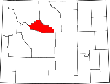 | |
| CDPs | ||
| Unincorporated community | ||
| Ghost town | ||
| Indian reservation | ||