Theodore Roosevelt Expressway
The Theodore Roosevelt Expressway (also known as the National Highway System High Priority Corridor 58), is made up of several existing highways between Rapid City, South Dakota and the Port of Raymond between Saskatchewan and Montana.[1] It is the northern third of the Ports to Plains Alliance. The corridor is approximately 445 miles (716 km) long with the majority of the highway two lanes.[2] Congress designated the route as one of 80 National Highway System high-priority corridors in 2005. The designation did not create new design standards or create new eligibility for any additional Federal funding.[3]
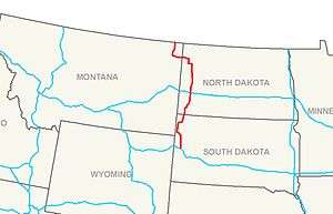
The route begins in Rapid City, South Dakota and runs north on U.S. Route 85 to Williston, North Dakota. From Williston, the route turns west on U.S. Route 2 to Culbertson, Montana where it turns north on Montana Highway 16 to the Canada–US border at Raymond, Montana.[4] The expressway takes its name from former President of the United States Theodore Roosevelt.
South Dakota
Through South Dakota, the route runs 160 miles (257 km) from Rapid City to the North Dakota state line.[2] The route runs concurrent with Interstate 90 from Rapid City west through Sturgis en route to Spearfish where it turns north onto U.S. 85. The route then continues in a northerly direction through Belle Fourche, Redig, Buffalo and Ludlow en route to the North Dakota state line.[5]
North Dakota
Through North Dakota, the route runs 197 miles (317 km) from the South Dakota state line to the Montana state line.[2] After crossing the state line, the highway continues north along U.S. 85 through Bowman, Amidon, Belfield (where it intersects Interstate 94), Fairfield, Grassy Butte, Watford City and Alexander before its junction with U.S. 2 just west of Williston.[5] The route then parallels U.S. 2 to the Montana state line.[5]
Montana
Through Montana, the route runs 88 miles (142 km) from the North Dakota state line to the Canada–US border.[2] After crossing the state line, the route continues west along U.S. 2 through Bainville en route to Culbertson. In Culbertson the route turns north along Montana Highway 16 through Froid, Medicine Lake, Antelope, Plentywood and Raymond before ending at the Port of Raymond.
References
- ↑ "Statutory Listing of Corridor Descriptions". Federal Highway Administration. Retrieved December 28, 2014.
- 1 2 3 4 Donovan, Lauren (January 20, 2008). "Building connections Association picks up Theodore Roosevelt Expressway". The Bismarck Tribune. pp. 1C.
- ↑ Rafferty, Tom (July 29, 2005). "Highway bill has big bucks for North Dakota". The Bismarck Tribune. pp. 1B.
- ↑ "NHS High Priority Corridors Description". Federal Highway Administration. Retrieved 2008-05-17.
- 1 2 3 "Map of the Theodore Roosevelt Expressway". Theodore Roosevelt Expressway. Retrieved 2008-05-17.
External links
- Theodore Roosevelt Expressway
- TRED Study from the Montana DOT