Wedge (border)
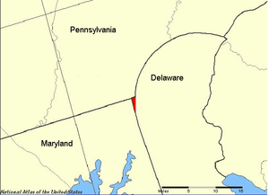
The Wedge (or Delaware Wedge) is a small tract of land along the borders of Delaware, Maryland and Pennsylvania. Ownership of the land was disputed until 1921; it is now recognized as part of Delaware.[1] The tract was created primarily by the shortcomings of contemporary surveying techniques. It is bounded on the north by an eastern extension of the east-west portion of the Mason–Dixon Line, on the west by the north-south portion of the Mason–Dixon line, and on the southeast by the New Castle, Delaware, Twelve-Mile Circle. The crossroads community of Mechanicsville, Delaware, lies within the area today.
History

The original 1632 charter for Maryland gave the Calverts what is now called the Delmarva Peninsula above the latitude of Watkins Point, Maryland up to the 40th parallel. A small Dutch settlement, Zwaanendael (1631–32), was within their territory, as were the later New Sweden and New Netherland settlements along the Delaware Bay and Delaware River. Although the Calverts publicly stated that they wanted the settlements removed, because of the foreign policy implications for the Crown, they did not personally confront them militarily.
In 1664, the Duke of York, brother of King Charles II, removed foreign authority over these settlements, but in the process the Crown eventually decided that the area around New Castle and the land below it on the Delaware Bay should be separated from Maryland and administered as a new colony.
In 1681, William Penn received his charter for Pennsylvania. This charter granted him land west of the Delaware River and north of the 40th parallel, but land within 12 miles (19 km) of New Castle was excluded. This demonstrates how poorly charted this area was, as New Castle is actually about 25 miles (40 km) south of the 40th parallel. The Penns later acquired the New Castle lands from the Duke of York, which they called the Three Lower Counties and are now known as Delaware. Delaware, however, remained a distinct possession from Pennsylvania.
The exact, and even approximate, boundaries of these three colonies remained in considerable dispute for the next 80 years. After settling Philadelphia and the surrounding area, the Penns discovered that it was actually below the 40th parallel, and tried to make claims to the land south of Philadelphia. The Calverts had failed to confirm their hold on their grant, either by surveying it or by establishing loyal settlers. The main progress during the 1750s was to survey the famous Twelve-Mile Circle around New Castle as the northern and western boundary of Delaware, and to establish the Transpeninsular Line as its southern border. An agreement was also reached between the Calverts and Penns that the boundary between their respective possessions would be:
- The Transpeninsular Line from the Atlantic Ocean to its midpoint to the Chesapeake Bay. According to NOAA, the Middle Point monument is at: (NAD27) 382735.8698 N / 754138.4554 W or (NAD83(91)) 382736.29213 N / 754137.18951 W. The monument is a short distance east of U.S. Route 50 near Mardela Springs, MD.
- A Tangent Line from the midpoint of the Transpeninsular Line to the western side of the Twelve-Mile Circle.
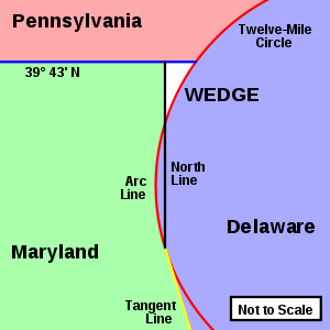
- A North Line from the tangent point to a line running 15 miles south of Philadelphia (approximately 39° 43' N latitude).
- The parallel at 39° 43' N was reached as a compromise to the 40th parallel.
- Should any land within the Twelve-Mile Circle fall west of the North Line, it would remain part of Delaware. (This indeed was the case, and this segment is known as the Arc Line.)
When this was agreed upon, no one knew what the final shape would really be. Mostly because of the difficulty of surveying the Twelve-Mile Circle tangent point and the Tangent Line, astronomer Charles Mason and surveyor Jeremiah Dixon were hired. This complex border became known as the Mason–Dixon Line. There turned out to be a small wedge of land between 39° 43' N latitude, the Twelve-Mile Circle, and the North Line. The top is roughly 0.75 miles (1.21 km), and the side is roughly 3 miles (4.8 km) long. Maryland clearly no longer had a claim to the Wedge, as it is east of the Mason–Dixon Line, and since the Penns owned both Pennsylvania and Delaware, there was no particular incentive to determine which possession it was a part of, at least until they became separate states.
- Pennsylvania claimed the Wedge because it was beyond the Twelve-Mile Circle and past the Maryland side of the Mason–Dixon Line, therefore part of neither Maryland nor Delaware.
- Delaware claimed the Wedge because it was never intended that Pennsylvania should go below the northern border of Maryland (which originally ran at 40° N all the way to the Delaware River). The North Line is logically an extension of the Tangent Line and therefore should separate Maryland and Delaware. Even though the Wedge is outside the Twelve-Mile Circle, because it is south of the 39° 43' N compromise line, it should not be part of Pennsylvania.

Mason and Dixon actually began surveying the Maryland-Pennsylvania border line at the Delaware River, or at least fixed the longitude of the intersection of 39° 43' N and the river. Even though this point is within the Twelve-Mile Circle, the western boundary of Pennsylvania was to be five degrees of longitude west of it, and Mason and Dixon were to survey the Maryland line to Pennsylvania's western border.
By simple geometry, the Wedge fit more logically as a part of Delaware, which exercised jurisdiction of the area. In 1849, Lt. Col. J. D. Graham of the U.S. Army Corps of Topographical Engineers resurveyed the northeast corner of Maryland and the Twelve-Mile Circle.[2] This survey reminded Pennsylvania of the issue and they once again claimed the Wedge. Delaware ignored the claim. In 1892, W.C. Hodgkins of the Office of the U. S. Coast and Geodetic Survey monumented an eastward extension of the Maryland-Pennsylvania border, and created the "Top of The Wedge Line". In 1921 both states settled on this boundary.
Contemporary routes
Delaware Route 273 and Delaware Route 896 cut across the Wedge. Route 896 passes very close to the tri-point, and actually passes through Maryland before entering Pennsylvania. Hopkins Bridge Road, a side road off Route 896, passes near the northeast corner of the Wedge, and passes from Delaware into Pennsylvania and back into Delaware at this point.
See also
References
- ↑ Delaware Federal Writers' Project (1976) [1938]. Delaware: A Guide to the First State. North American Book Dist LLC. pp. 457–459. ISBN 9780403021604.
- ↑ "J. D. Graham Papers.". Yale Collection of Western Americana. Beinecke Rare Book and Manuscript Library. Retrieved 19 October 2014.
External links
| Wikisource has the text of the 1905 New International Encyclopedia article No Man's Land. |
- The Boundary Disputes of Colonial Maryland
- Delaware's State Boundaries
- Area outlined on Google Maps' hybrid view
- "USCGS ARC CORNER Stone, 1892, Delaware-Pennsylvania" Waymark
Coordinates: 39°42′52″N 75°47′5″W / 39.71444°N 75.78472°W