The Oa

The Oa (/ˈoʊ/ OH)[1] (Scottish Gaelic: An Obha) is a rocky region in the southwest of Islay, in Argyll, Scotland. It is an RSPB nature reserve.
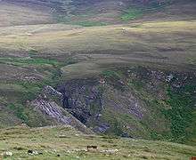
The area is almost an island; its high point is Beinn Mhòr 202 metres (663 ft), in the south. It used to have a population of 800[2] in 1830 but became deserted due to the Highland Clearances. The American Monument was erected on the south coast by the American Red Cross to commemorate the loss of two ships in 1918, SS Tuscania, a passenger liner, and HMS Otranto.[2]
The area around the memorial is an RSPB Nature Reserve,[3] where chough, golden eagles, corncrakes and sea birds can be seen. 1,931 hectares (4,770 acres) have been designated as a Special Protection Area for the protection of the chough.[2] Ireland can be seen from the south peninsula on a clear day.[4]
Footnotes
- ↑ Ayto, John and Crofton, Ian (2005). Brewer's Britain And Ireland. Weidenfeld & Nicolson. p. 829.
- 1 2 3 "The Oa Peninsula". Guide to the Isle of Islay. Retrieved 2009-07-26.
- ↑ "The Oa". RSPB. Retrieved 2009-07-26.
- ↑ United Kingdom Ordnance Survey Map, Landranger, 1:50,000 scale
External links
| Wikimedia Commons has media related to The Oa (Islay). |
Coordinates: 55°37′N 6°17′W / 55.617°N 6.283°W