The Kink
For the rock band, see The Kinks. For other uses of "Kink", see Kink (disambiguation).
|
The Kink | |
|
A miner's cabin at The Kink | |
 | |
| Nearest city | Fairbanks, Alaska |
|---|---|
| Coordinates | 64°23′7.9″N 142°1′40.9″W / 64.385528°N 142.028028°WCoordinates: 64°23′7.9″N 142°1′40.9″W / 64.385528°N 142.028028°W |
| Area | 280 acres (110 ha) |
| Built | 1904 |
| NRHP Reference # | 75002161[1] |
| Added to NRHP | November 20, 1975 |
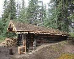
The Kink is a manmade feature of the North Fork Fortymile River in remote eastern Alaska. It is a channel that was blasted through a rock ridge by gold miners in 1904, in the belief that a horseshoe-shaped meander that the river's flow would bypass by the creation of the channel would be rich in gold (it wasn't). The area includes the remnants of a small mining camp. The creation of the channel was a major engineering feat of the time, given the remote location and harsh climate (conditions that continue to apply today).[2]
The Kink was listed on the National Register of Historic Places in 1975.[1]
See also
References
- 1 2 National Park Service (2010-07-09). "National Register Information System". National Register of Historic Places. National Park Service.
- ↑ "NRHP nomination for The Kink" (PDF). National Park Service. Retrieved 2014-11-23.
| Topics | |
|---|---|
| Lists by states |
|
| Lists by insular areas | |
| Lists by associated states | |
| Other areas | |
| |
This article is issued from Wikipedia - version of the 11/30/2016. The text is available under the Creative Commons Attribution/Share Alike but additional terms may apply for the media files.